
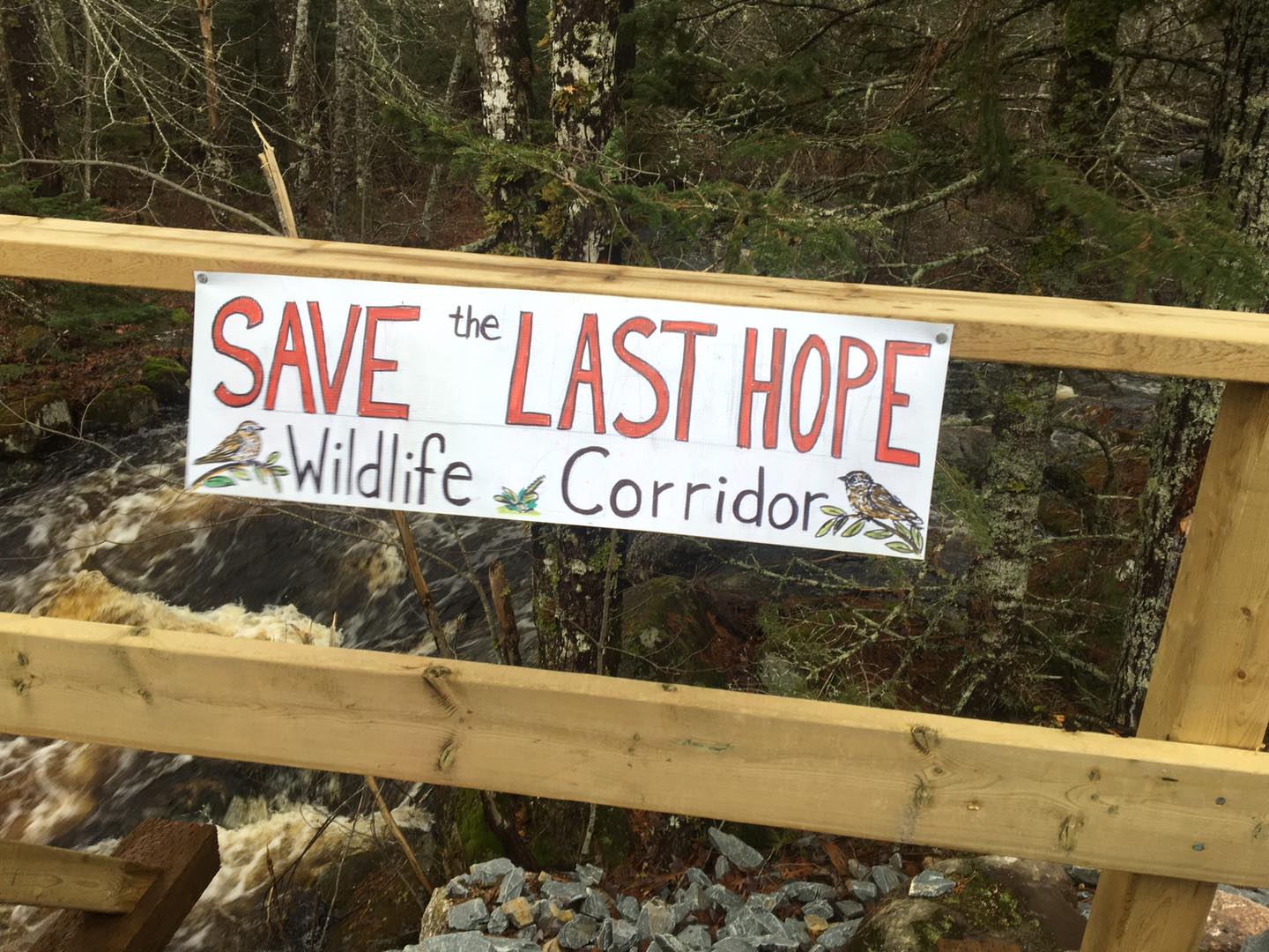
Sign at the Last Hope Wildlife Corridor Encampment underscores the landscape level values of AP068499 Beals Meadow “The real question is not how should this parcel be cut but should it be cut at all? Bowater-Mersey left this parcel alone when they were cutting everything else in reach because of its value to wildlife. Has wildlife recovered in the intervening years?” – Nina Newington
“Logging the Best and Leaving the Rest” is occurring on the Crown lands all over the province including the area of AP068499 Beals Meadow. It is “Highgrading at the Landscape Level”
CONTENTS
– Background
– What is “Highgrading”?
– Highgrading at the Landscape level
– Is Highgrading at the Landscape Level happening in the vicinity of AP068499 Beals Meadow?
Postscript
– A provisional definition of Highgrading at the landscape Level
– On Highgrading at the Landscape Level and Wood Supply
—-
– To Comment
Background
Currently there is a stand-off between the Nova Scotia Government/NS Dept of Natural Resources and Renewables (NSNRR or NRR) and citizens who are taking direct action to block government-approved logging on Crown land parcel AP068499 Beals Meadow by the WestFor consortium.
The government maintains that their prescribed Uniform Shelterwood harvest of 30-35% of trees “aligns with the new Silviculture Guide [SGEM] for the Ecological Matrix and Lahey recommendations” and therefore (by implication) should be acceptable to all. They do not recognize the area as a wildlife corridor, as contended by Randy Neily, a long time hunter/fisher and observer of the area.
Other opponents of the logging say that while the approved harvest is or may be in conformity with the SGEM, it overlooks other aspects of the Lahey recommendations, most notably those related to landscape level issues (which are not addressed by the SGEM which is a stand-level decision-making process); they say it is critical to address landscape level issues because of the intensity of harvesting over the broader area. For more details view Current Issues/AP068499 Beals Meadow and NRR’s Line in the Sand (both on this website).
In a previous post, this post and in two or three further posts on NSFN, I explore these positions and related evidence. In the first post I looked at the extent of clearcutting in the vicinity of AP068499 Beal’s Meadow. It was clear that there has been plenty. In this post I look at what’s left on the landscape as revealed by the Forest Development Class Layer on the Provincial Landscape Viewer (PLV).
What is “Highgrading”?
“Highgrading” or “logging the best and leaving the rest” is a term applied by foresters to individual forest stands*
high grading – the removal of only the best trees from a stand, often resulting in a poor quality remaining stand and poor seed for the next generation – Glossary of Key Terms for the NS Woodlot Home Study Module 2
*A forest “stand” is ” group of trees, with similarities in species composition, height/diameter distribution, and age composition as well as similar site and soil conditions” (SOURCE). The “polygons” identified in digital mapping of our forests correspond or are intended to correspond to distinct forest stands on the ground. View What is a “forest Polygon”.
Highgrading is often cited as the sin of our forefathers, and one that modern forestry moved away from.
By the 1950s, Crown land was still managed primarily for timber production but there was a move away from exploitative forestry, with a tendency to take the best trees (e.g. ‘high-grading’), towards management and silvicultural practices that could produce a regular supply of timber. – Graham Forbes (2019) TRIAD – A NEW VISION, posted on the L&F/NRR Ecological Forestry Website
It’s odd to me that clearcutting, which takes everything, is not considered a form of high grading. I guess the idea is that it doesn’t favour poor quality over high quality trees (they are all taken), also because, sometimes, a few older, larger seed trees are spared, the genetic impact may not be not as strong as it is with classic, selective high grading. But it does reduce the quality of our forests for both sawmills and wildlife nonetheless.
Highgrading at the Landscape level
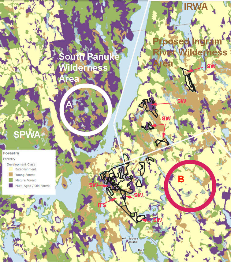
The map below shows the Forest Development Class for an area above St. Margaret’s Bay on the Atlantic coast SW of Halifax. It includes a portion of the South Panuke Wilderness Area; to the east, within the white lines, lies a portion of the Proposed Ingram River Wilderness Area, and to the south of that, land not in either existing or proposed Wilderness Areas. In general,* the darker the patches, the more advanced the development class and the older the forest. * There could be instances in which a patch of older, even aged Mature Forest (green), e.g., 150 years old, lies adjacent to a patch of younger Multi-aged/Old Forest (purple), e.g. 120 years old.
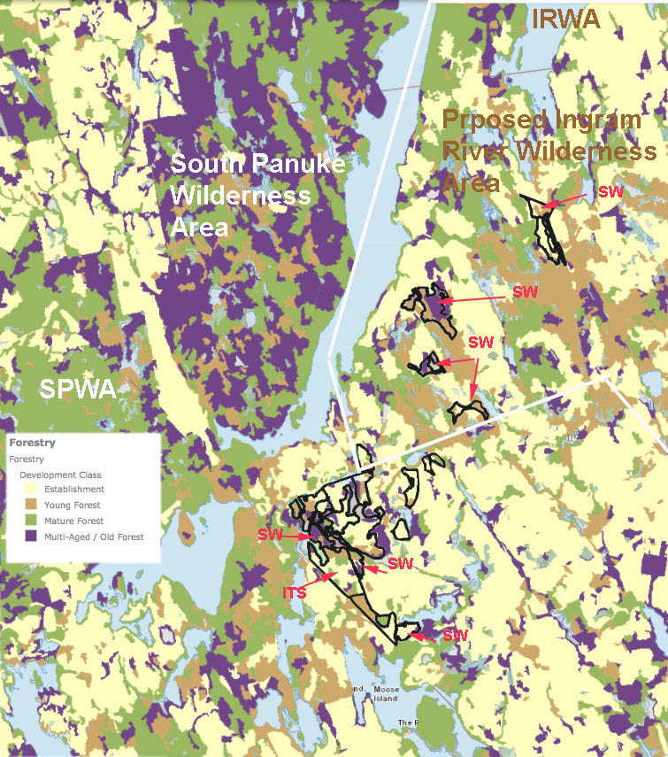
Harvest polygons from the HPMV layered over Forest Development Class from the Provincial Landscape Viewer. The areas to the northwest that are mostly Mature Forest/Multi-aged Old Forest (green and purple patches) are in the South Panuke Protected Wilderness Area. Prescriptions are SW-Shelterwood, ITS-Individual Tree Selection; the rest are Commercial Thinning. The area enclosed by the white borders lies within the proposed Ingram River Wilderness Area. The polygons are planned harvests from the Harvest Plan Map Viewer (accessed on Jan 11, 2021); these are located within the area of the proposed Ingram River Wilderness Area but are outside the area that L&F/NRR is considering for protection and those to the south are outside of any existing or proposed protected areas.
A large portion of the South Panuke Wilderness Area was evidently spared the harvesting that occurred to the west, east and southeast of it and illustrates a more natural state of forests in this region.
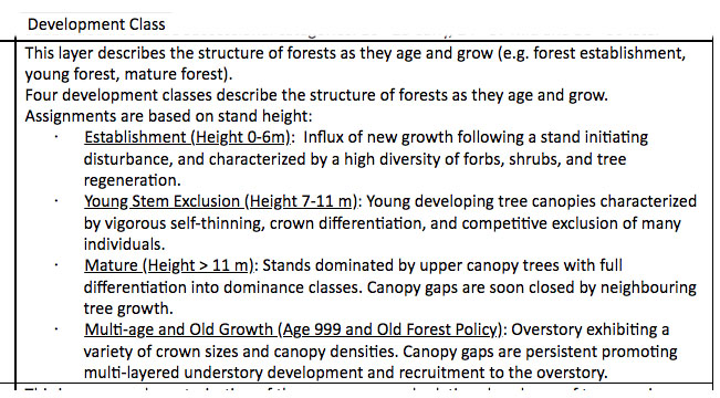
The 4 Development Classes (From PLV help)
It’s pretty clear that the ongoing harvests are targeting, where they can, the purple patches which represent the most advanced stand development class (Multi-aged/Old Forest), turning the area into predominantly yellow, Establishment Class forests.
Surely this is a form of “logging the best and leaving the rest” not at the stand level but at the landscape level. It is shifting the age distribution of the forests towards the younger ages, thereby reducing potential supply of bigger trees to mills in the future; and it is drastically reducing habitat needed to maintain old forest biodiversity. It is changing the quality of our forests as much as classically conceived highgrading and so can be viewed as Highgrading at the Landscape Level.
Such highgrading can proceed through repeated larger cuts &/or repeated smaller cuts on a landscape, even by Individual Tree Selection. (The ITS polygon in the map above looks like a possible example).
In a letter to Forestry Maps on Oct 15, 2020, Bev Wigney wrote
…What’s with all of these little cuts between already devastated forests that are now gone, like the parcels up for approval around Paradise Lake? Now you seem to be posting tons of these small stands – on one of the last Forestry Maps listings, about 1/3 of all the parcels were just small parcels — many just 2 ha. What are these? Why weren’t they cut down earlier? Were they left standing as wildlife shelter areas so that you COULD go ahead and cut down everything around them?
I went out and looked at some of them. They aren’t hard to find as they are the LAST and ONLY patches of forest left standing in between the *already devastated* parcels where there is NOTHING anymore. Where do you expect the wildlife to “move to” next when you cut down the very last parcels between the already clearcut areas?
View more about Highgrading at the Landscape Level in NS in these posts:
Landscape-level “Log the best and leave the rest” on Nova Scotia’s Crown land forests 10Jan 2021
Posted on Jan 10, 2021. Also view: “Log the best and leave the rest” – A conversation with David Patriquin about the state of our forests by By RobertDevet in the NS Advocate Jan 13, 2021Nova Scotia PI204568 (Pictou Co.) Landscape level High-grading continued, and thinking about alternatives
Posted on January 16, 2021“it is very poor land, very poor quality wood, its best function would be to just leave it alone”
Posted on February 22, 2018Clearcut Nova Scotia continued..4July2017 & highgrading at the landscape level
Posted on July 6, 2017, 2017Latest Nova Scotia Crown land allocation includes residual Deer Winter Area
Posted on June 25, 2017
High-grading at the landscape level on Bowater – Mersey St. Margaret’s Bay (now Crown) Lands
“When I went on these lands twenty or so years ago, I would consistently see 5 or 6 deer, 4 or 5 red-
tailed hawks, a barred owl or two,lots of nighthawks and many warblers…today I often see nothing, not even a porcupine.I have heard barred owls but I have not seen one in years.- Naturalist
Is Highgrading at the Landscape Level happening in the vicinity of AP068499 Beals Meadow?
Two maps available in the public domain are relevant.
#1 From the Harvest Plan Map Viewer (viewed Jan 19, 2022):
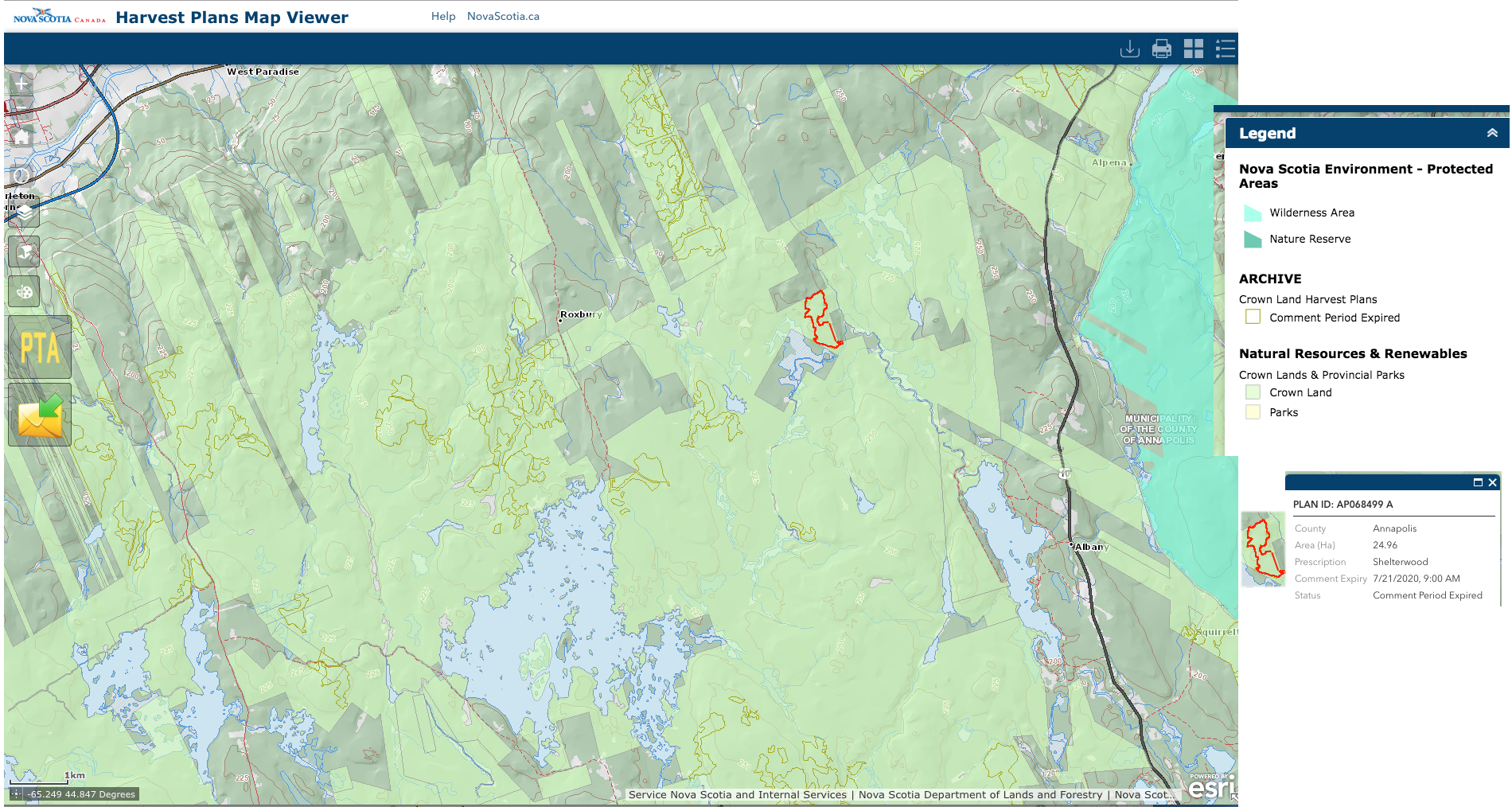
The map shows the area of Crown land, and harvests approved since March 2016 in the vicinity of AP068499 Beals Meadow (he red-highlighted area).
#2 From the Provincial Landscape Viewer, with approved harvests overlaid.
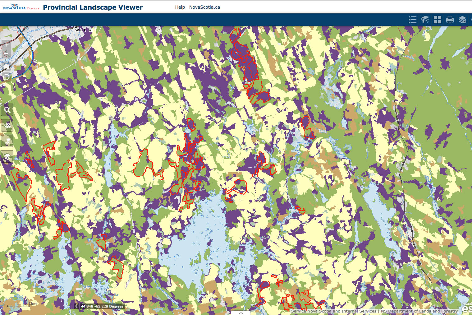
Planned Harvests March 2016 from the HPMV superimposed on Forest Development Class layer from the NS Provincial Landscape Viewer
The planned harvests are clearly targeting the purple patches, a large patch of purple in AP068499 Beals Meadow amongst them. Compare this map with # 1, and you can see that some of the larger aggregations of purple or purple and green patches remaining in this landscape are on private land, also in the wilderness area to the east. So the Crown landscape is becoming yellower, and the development class shifting very quickly towards a predominance of recovering, Establishment Class forests.
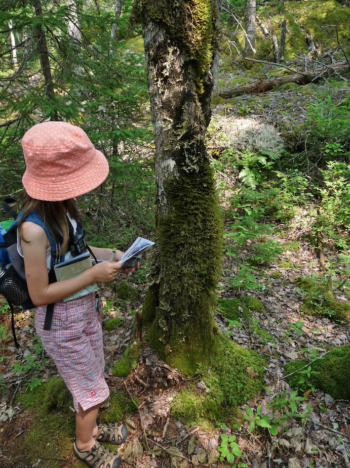
Young naturalist observing tree moss on a forest outing. We must all be given opportunities to enjoy and contribute to healthy Crown land forests say Addie & Fred Campaigne
As a result, there is/will be
– significant decline in abundance of species dependent on older forest habitat and connectivity;
– significant loss of carbon storage;
– significantly more erosion and erratic stream flows;
– more degradation of aquatic habitats;
And as the losses are mostly on the Crown (public) lands it also results in more loss of forests that can be enjoyed recreationally and for physical and mental health benefits by all Nova Scotians.
That is the context in which the APOAP068499 Beals Meadow was approved. It is NOT applying the Lahey recommendations as he intended.
In other words, I have concluded that protecting ecosystems and biodiversity should not be balanced against other objectives and values as if they were of equal weight or importance to those other objectives or values. Instead, protecting and enhancing ecosystems should be the objective (the outcome) of how we balance environmental, social, and economic objectives and values in practising forestry in Nova Scotia. – William Lahey in An Independent Review of Forest Practices in Nova Scotia (2018)
We have yet to see any significant Landscape Level Planning for Biodiversity – which should be in the backdrop for selecting sites for High Production Forestry and approving harvests in the Ecological Matrix – in the output to-date of draft or final documents from the Ecological Forestry component of NRR. The Old Forest Policy was expected to include some but didn’t (view docs listed under Consultations/Old Growth).
All that is left at this point is an informal commitment by Prof. Peter Duinker to Landscape level Planning in the Forest Stewardship Guide which he and other consultants are working on but about which we know essentially nothing. Who knows how many years of status quo could occur while we wait for the whole Forestry EA process to be fleshed out. (The EA process? One can be forgiven for asking. It is one of the Ecological Forestry priority projects.)
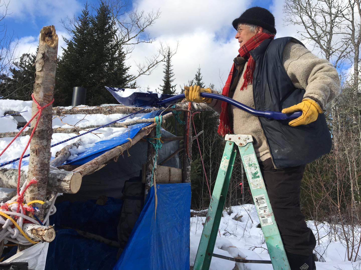
Nina Newington doing chores at Last Hope Wildlife Corridor Encampment. Photo by Sandra Phinney/Extinction Rebellion Mi’kma’ki / Nova Scotia
I hope this all helps to explain why Nina Newington said this on Day 2 of the Last Hope Wildlife Corridor encampment:
The heart of the issue is how the decision was made that this forest was available for harvesting. The Lahey report and review point to the necessity for landscape level planning. In other words, before you decide if one particular parcel should be approved, there needs to be a planning process to decide which areas must be protected because they are important to the ecological health of the whole.
… and why 55 days later she and others are still there, through many brutal winter days.
Also view Beals Brook harvest ignores the landscape context on naturens.ca. “Nature Nova Scotia considers the harvest planned for Beal’s Brook (harvest plan AP068499) to be ill-aligned with the province’s goals around ecological forestry and ask that the area be conserved through the protected areas system instead; read Letter from Bob Bancroft on behalf of Nature Nova Scotia to Minister Tory Rushton, Jan 2, 2022.”
Post-script
A provisional definition of Highgrading at the landscape Level
It’s not a term used by foresters or to be found in forestry glossaries. So here’s a go at a formal, functional definition:
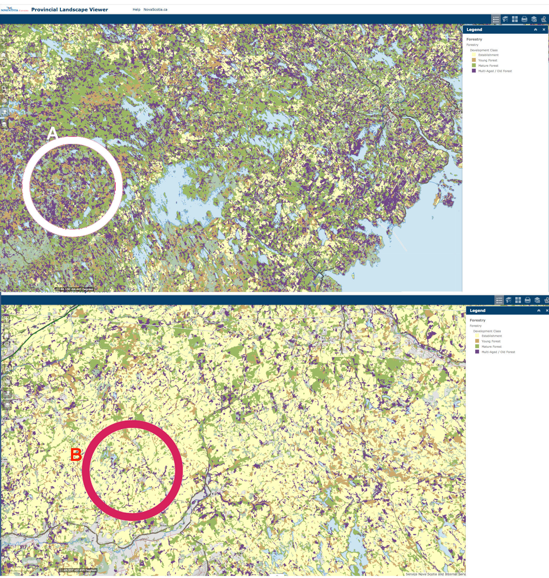
Highgrading at the Landscape Level is the selective removal on a forested landscape of stands in the most advanced development class (classes 3 and 4 in the Nova Scotia scheme) over a period of time such that if continued will result in the replacement of a landscape in which more advanced classes occupied at least 60% of the area to one in which the early development classes (classes 1 and 2 in the Nova Scotia scheme) occupy 85% of more of the landscape.
In most if not all forested landscapes in NS, the natural condition is for the more advanced development classes (classes 3 and 4 ) to occupy at least 60% of the area; thus if currently on a landscape or portion of a landscape early development classes (classes 1 and 2 in the Nova Scotia scheme) occupy 85% of more of the landscape, it’s highly likely that landscape has been subject to intense Highgrading at the Landscape Level.
Examples
| Ex. 1. Stands Close-by | Ex. 2. Stand in separate regions of NS |
 A: In a Protected Area, >60% Classes 3 & 4 B: in working forest, >85% Classes 1 & 2 Diameter of circle approx 2 km. Click on image for larger version
|
On Highgrading at the Landscape Level and Wood Supply
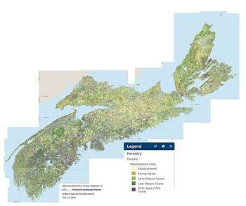
Why are the Big Mills (WestFor) so focussed on SW Nova Scotia? Map shows the distribution of forest in 4 Development Classes across Nova Scotia, compiled from NS Landscape Map Viewer. Purple = Multi-aged/Old Forest. View Larger version
One would think that our big sawmills would be concerned about “Highgrading at the Landscape Level” because it means that in future, there will be a very reduced supply of larger diameter sawlogs.
And perhaps they are concerned and manage accordingly on their own lands, but we don’t hear of any concerns of this nature from the WestFor consortium; and it seems likely that one reason the big sawmills are so interested in SW Nova Scotia – on both public and private lands -, is that past Highgrading at the Landscape Level has greatly reduced the volumes of larger diameter sawlogs on landscapes in central and eastern NS.
The forest industry at large and in NS is now well prepared technologically to make use of smaller diameter logs (10-12 ” and less) to meet building material needs through the production of ‘engineered’ or ‘mass’ timber. In fact the High Production Forestry Phase 1 – Discussion Paper specifies a need to grow trees to only 8-12 ” diameter.
As one of the key objectives of the High Production Forest zone is to grow an abundance of saw material products (i.e saw timber, or sawables), each of the species growth and yields have been modelled with this as the focus. Red spruce plantations have been modelled to achieve an average diameter of 12” (30cm), with a focus on maximizing sawlog volumes from a piece size which is efficient for sawmills to utilize. White spruce plantations have been modelled to achieve an average diameter of 10” (26cm), with a focus on maximizing both sawlog and studwood volumes from a piece size which is efficient for either stud mills or sawmills to utilize. Norway spruce has market limitations and cannot be utilized for sawlogs, therefore Norway spruce plantations have been modelled to achieve an average diameter of 8” (20cm), with a focus on maximizing studwood volumes from a piece size which is efficient for stud mills to utilize.
So the sawmills need not be concerned much about future supply of large diameter trees – but in the meantime, such trees are still much more profitable, so why not harvest them, and keep our industry highly competitive and profits high? I.e. there is little incentive on the part of the big sawmills to advocate reducing harvests of the older forests for ecological reasons. At least that’s the way it looks.
View more on this topic in this post: Protecting supply of “wood” but not necessarily big trees from Nova Scotia’s Crown lands remains the priority at L&F 15Mar2020
To Comment
I have blocked comments on nsforestnotes.ca because, based on past experience managing WordPress websites (e.g., for Halifax Field Naturalists), I could anticipate that more than 99% of responses would be spam.
I do appreciate constructive dialogue, however. A good venue for that is the Woods and Waters Nova Scotia Facebook page which is hosted by Mike Parker.
Says Mike:
W&WNS is committed to being an equal opportunity forum for both sides of the forestry debate. Mistakes happen. Unlike social media where an error can be edited for correction, radio / television doesn’t allow for a do over. Calling someone, anyone, on this page a liar is teetering on the brink of being shown the door. Participation on W&WNS is not an inherent right. For those who missed the memo, there is to be no profanity or character assassination. Decorum will prevail. Otherwise go elsewhere.
Mike posts something about most of my blog posts or sometimes I go there and do it myself (which he later approves, or not, and then they appear on the W&WNS Facebook page). In addition to being able to comment on my posts, you will see lots of other interesting posts and discussions on W&WNS.
& if someone from the Forest Industry or NRR wants to respond in a bit of detail to my comments, I would very willingly allow such comments to be made in a “Guest Post” on NS Forest Notes.
– David P