
Copies of some correspondence of BW with Forestry Maps reported on Annapolis Royal & Area – Environment & Ecology
BW’S INITIAL SUBMISSION TO FORESTRY MAPS
July 21, 2020
Comment submission for harvest block #AP068719C
User Information:
Name: Bev Wigney
Email: bkwigney@gmail.com<mailto:bkwigney@gmail.com>
Form Information:
Under the Southwest Nova Scotia Habitat Conservation Strategy, an area that
is encompassed by these parcels being referred to as “Godfrey Lake”, have
been given a HIGH ranking in the Conservation Value Index (CVI) and a VERY HIGH ranking under Priority Habitat Composite (PHC). Considering that we areSTILL WAITING to find out which forests will be designated as ECOLOGICAL
MATRIX FORESTS under the Lahey Triad plan, why are you even considering
doing any chopping up of an area which has a high CVI ranking? What’s the
big rush to get in there making major alterations to this forest? You’ve
already chopped up much of the other forest in that area south of West
Dalhousie Road. This area shouldn’t be logged AT ALL until it has been
properly assessed by those who actually know something about critical
habitat for flora and fauna. To go in CHOPPING it up be fore it has been
properly assessed is “backwards” (in the “ignorant and uneducated” sense of
that word). These Godfrey Lake parcels should be REMOVED from the roster for
Shelterwood (2-STAGE CLEAR-CUTTING) and set aside to be considered as vital
forests for the Ecological Matrix Forests at such time as those are
established.
Date Submitted: 21/07/2020 4:15:25 PM
for reference, extract from the Forestry Maps Notice:
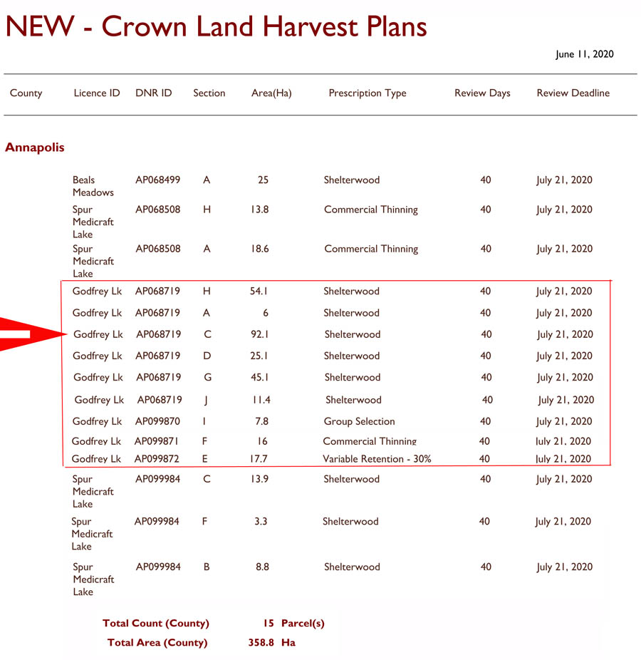
Lotta Crown Land
Lotta Older High Volume Forest still left south and southeast of Godfrey Lake
Lotta Approved Harvests south and south east of Godfrey Lake
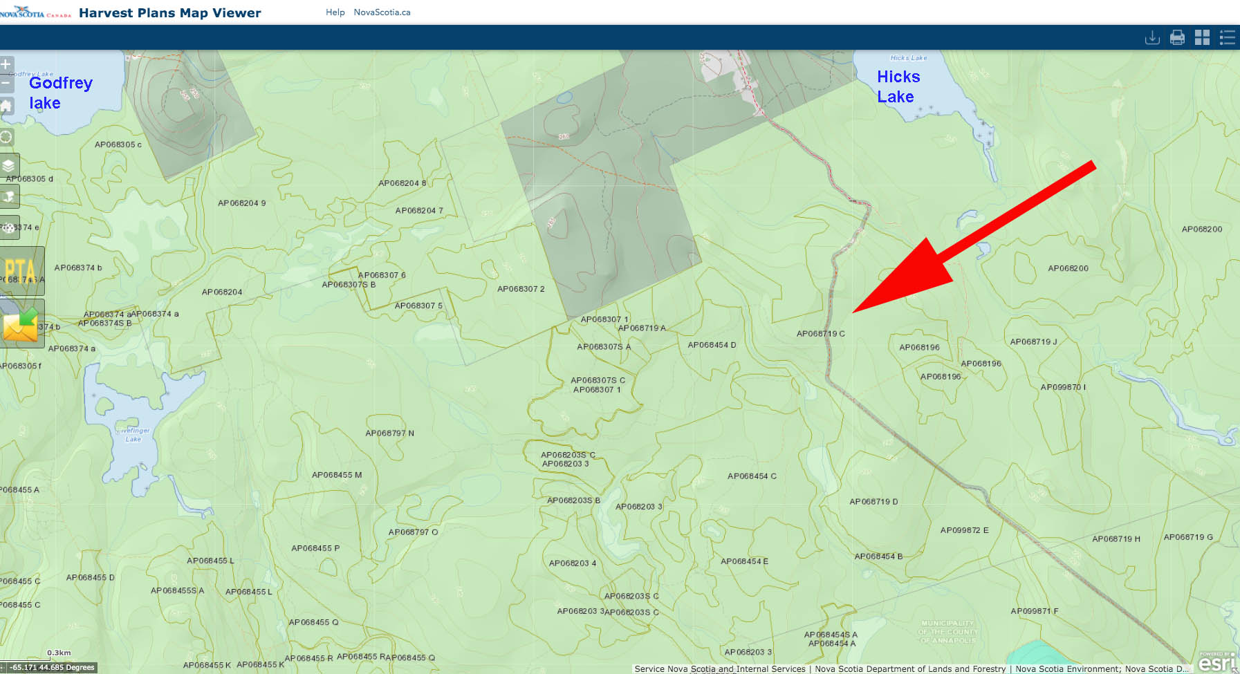
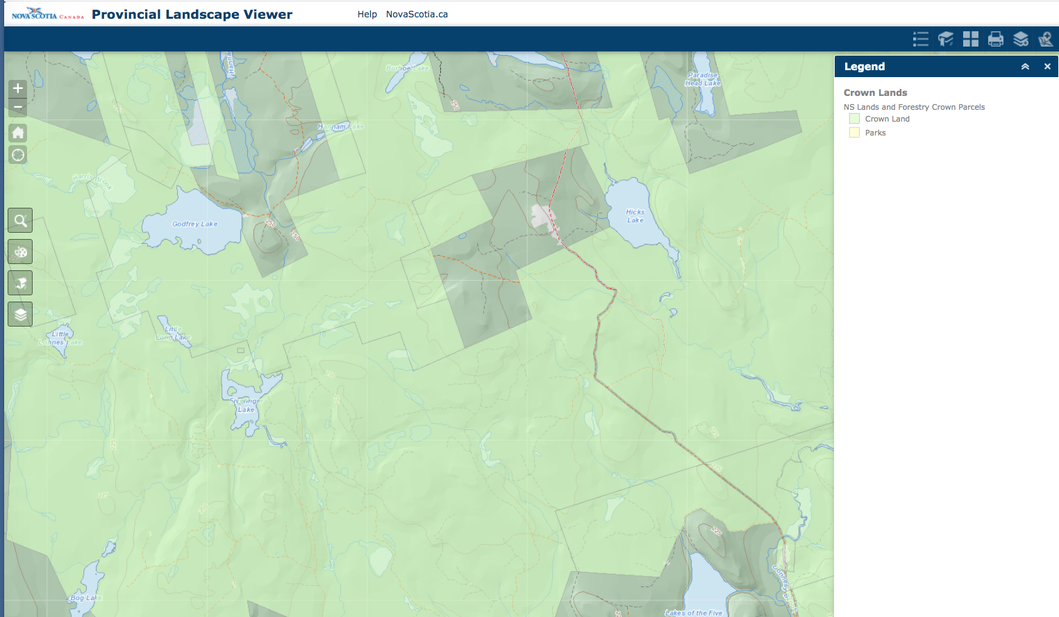
Some details, Red arrow points to parcel BW highlighted to Forestry Maps
Oct 15, 2020, ~ 5 pm
Dear Bev Wigney,
Government continues to be committed to adopting a model that protects ecosystems and biodiversity, supports economic growth, keeps our forest healthy and sustainable, and to fully implement ecological forestry in Nova Scotia. We can assure you that even during these challenging times we all face, the department continues to focus our priorities and resources on the recommendations from Professor Lahey’s independent review of forest practices in Nova Scotia.
There have already been significant changes in harvest practices on Crown lands since we introduced the Interim Retention Guide in December 2018. The Interim Retention Guide has increased the retention (of live trees) in situations where the Forest Management Guide prescribed clearcuts until a new Forest Management Guide was ready. As a result of the retention, many of the harvest methods being used will not result in even-aged stands and many do not meet the definition of a clearcut.
For harvests proposed in calendar year 2018 (before the interim retention guide), 68% resulted in 10% or less retention and 32% resulted in greater than 40% retention. In 2019, 50% of proposed harvests resulted in 10% or less retention, 15% in 10-20% retention and 35% in greater than 40% retention. So far in 2020, 27% of proposed harvests resulted in 10% or less retention, 28% in 10-20% retention and 46% in greater than 40% retention.
Another way to look at the change that has taken place is to look at the overall % of non-clearcut harvests proposed. Assuming all harvests that retain 20% or less of the standing trees are considered to be a clearcut (most of these harvests can be expected to meet the departments definition of a clearcut) and those harvests retaining over 20% of the standing timber as non-clearcut. By this measure the non-clearcut increased from 32% proposed harvests in 2018 to 43% in 2019 and to 59% to date in 2020. That is a 27% reduction, since the implementation of the Interim Retention Guide, in the amount of proposed harvests that are clearcuts by definition.
For updated information about Ecological Forestry and the progress the Department of Lands and Forestry is making in its implementation, please visit our Ecological Forestry website:
https://novascotia.ca/ecological-forestry/. If you would like to provide more input on ecological forestry, please send those comments to ecologicalforestry@novascotia.ca<mailto:ecologicalforestry@novascotia.ca>
Thank you for your interest in our natural resources.
Forestry Maps
Department of Lands and Forestry
Renewable Resources
https://novascotia.ca/ecological-forestry/
COMMENT (NSFN): RE “Another way to look at the change that has taken place is to look at the overall % of non-clearcut harvests proposed. Assuming all harvests that retain 20% or less of the standing trees are considered to be a clearcut (most of these harvests can be expected to meet the departments definition of a clearcut) and those harvests retaining over 20% of the standing timber as non-clearcut. By this measure the non-clearcut increased from 32% proposed harvests in 2018 to 43% in 2019 and to 59% to date in 2020. That is a 27% reduction, since the implementation of the Interim Retention Guide, in the amount of proposed harvests that are clearcuts by definition.” – As far as I can see, by their own 2012 definition, which still stands, even 30% retention is a clearcut: VIEW https://novascotia.ca/natr/strategy/pdf/Clearcut_Definition.pdf
========================================================
BW RESPONDS
Oct 15, 2020, ~ 5 pm
This is a letter just sent to the entity that refers to itself as “Forestry Maps” (see my previous post from a few minutes ago) [above]
++++
Dear Forestry Maps,
What about all the Shelterwood cuts? How are we to regard them? You aren’t specifying which kind of Shelterwoods these are. If they are typical Shelterwoods, then they are just a two stage Clearcut.
Anyhow, whatever the criteria, Annapolis County must have ended up with the lion’s share of clearcuts and the less 20% or less retentions as we’re getting massacred down here. Also, what’s with all of these little cuts between already devastated forests that are now gone, like the parcels up for approval around Paradise Lake? Now you seem to be posting tons of these small stands – on one of the last Forestry Maps listings, about 1/3 of all the parcels were just small parcels — many just 2 ha. What are these? Why weren’t they cut down earlier? Were they left standing as wildlife shelter areas so that you COULD go ahead and cut down everything around them?
I went out and looked at some of them. They aren’t hard to find as they are the LAST and ONLY patches of forest left standing in between the *already devastated* parcels where there is NOTHING anymore. Where do you expect the wildlife to “move to” next when you cut down the very last parcels between the already clearcut areas? Does this seem right to you (whoever you are who is reading this and replying)?
Are all of the clearcuts we are still seeing, from previously approved harvests and how many more years is that going to drag on for? People around here — biologists, foresters, naturalists, everyone — is really sick and tired of what is happening around here. Do you ever actually go out and look at what a big mess it is after these harvests take place? Do you ever go and see all the trees that were hacked down, and then it was discovered they were hollow inside, so they just dragged them to the roadside and left lying to rot jn the mud — trees that were providing shelter for nesting owls and all sorts of other creatures?
I sometimes wonder if anyone there actually goes out and walks around to see the mud-filled brooks, the little wetlands that have been all filled with rock to make roads to get at forests, the immature Sugar Maple stands that have been cut down to “get at” the nice big Maples that are back in from the road accesses. The cancerous growth of road systems that are now available for poachers to get in and kill Moose and other wildlife? My guess is that most of you never leave your offices. If you did, you wouldn’t be so cavalier about hacking down so much of our forests.
END
========================================================
FORESTRY MAPS RESPONSE #2
Oct 15, 2020, ~ 8 pm
Dear Bev Wigney,
Department of Lands and Forestry resource management professionals review every proposed harvest plan as part of the Integrated Resource Management (IRM) review process and determine if the plan is appropriate and meets all requirements for
operating on Crown lands. The IRM team considers many things including (but not limited to): the provincial strategic forest management plan, property lines and land ownerships, adjacency to protected areas, wildlife habitat, wetlands, geological information, known recreational activities, areas of significance to Mi’kmaq, and requirements for Special Management Practices (SMP).
The Southwest Nova Scotia Conservation Strategy was a project lead by Mersey Tobeatic Research Institute (MTRI) staff. The department was not an official partner of the project. Although the work completed within the project is important to help to understanding biodiversity in western Nova Scotia it is not part of the Integrated Resource Management teams review.
Government continues to be committed to adopting a model that protects ecosystems and biodiversity, supports economic growth, keeps our forest healthy and sustainable, and to fully implement ecological forestry in Nova Scotia. We can assure you that even during these challenging times we all face, the department continues to focus our priorities and resources on the recommendations from Professor Lahey’s independent review of forest practices in Nova Scotia.
The department has held public consultations on draft criteria for high production zones and is also moving ahead with the next phase of consultations on the draft Silviculture Guide for the Ecological Matrix.
https://novascotia.ca/news/release/?id=20200220002.
Thank you for your interest in our natural resources.
Forestry Maps
Department of Lands and Forestry
=========================
BW RESPONDS TO FORESTRY MAPS
> From: BW
> Date: Thu, 15 Oct 2020 19:11:16 -0300
> Subject: Re: Harvest Plans Map – Comments for BlockID #AP068719C
> To: Forestry Maps <ForestryMaps@novascotia.ca>
Dear Forestry Maps Entity,
It’s really rather unfortunate that the Integrated Resource Management
team *does not* endeavour or wish to take into account the data of the
Southwest Nova Scotia Conservation Strategy. In my own surveys of
Annapolis County, I have found it to be EXTREMELY USEFUL in
pinpointing ecologically valuable properties with excellent
biodiversity – properties that should be reserved for protection, or as
ecological matrix. I suppose you don’t want to make use of that data
because it would *interfere* with your plans for cutting down of these
forests. Your motives have become oh-so-predictable. I really wish
you would accept the fact that there are actually “other people” and
organizations in this province who are doing admirable work and actually
know something and could be valuable resources in protecting the
biodiversity of our forests. Unfortunately, I guess you’re more
comfortable just listening to the little voices in your own heads.
*sigh*