
What you get and some of what
you do not get on the Harvest Plan Map Viewer
(and where to get it)
Page posted Jan 3, 2019
Modifications to Wishlist on Jan 4, 2019
- Introduction
- WHAT YOU GET
- Viewing locations of Proposed Harvests
- Requesting a PTA
- Submitting Comments independently of the PTA
- What else is on the HPMV – Protected Areas
- What else is on the HPMV – Roads
- SOME OF WHAT’S NOT AVAILABLE ON THE HPMV BUT CAN BE ACCESSED ELSEWHERE
- On the Provincial Landscape Viewer (PLV)
- Wildlife Layer on the PLV
- Old Forest Policy on the PLV
- Forest Development Class layer on the PLV
- Forest Volume Class layer on the PLV
- Forest Species and Stand layers on the PLV
- Ecological Emphasis layer on the PLV
- Ecological Land Classification on the PLV
- NSE: Watersheds
- Parks and Protected Areas
- Wind exposure and Soil Type layers on the Pre-Treatment Assessment Reference Viewer
- Satellite View by Month in Planet Explorer
- COMMENTS (WISHLIST)
- FOOTNOTES
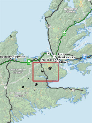
As an illustration of What you Get and Do Not Get, I simply chose an area in eastern Nova Scotia where I could see some newly proposed harvests (viewed Jan 1, 2018), and then used the HPMV and other online map tools to see what I could find out about the area.
Introduction
The Harvest Plan Map Viewer (HPMV) was launched by NSDNR on April 18, 2016. It replaced the “pdf-based harvest operation maps that the Department of Natural Resources launched in 2014.” (View example of the PDFs.)
The HPMV was a huge improvement and technically this interactive tool is user-friendly and is very robust (it’s fast and consistent). Several improvements were made over time and I have found the HPMV staff very responsive to requests for clarification, info etc. (View posts under HPMV category).
I have encountered few issues in accessing the information the HPMV is designed to provide, and it has clearly improved “public engagement on planned fibre harvests in Nova Scotia woodlands” (from 2016 Press Release).
However, there is a lot more that the platform could offer to provide more context to the proposed harvests, but does not. An example, once harvests have been approved and commenced, they are taken off the HPMV, so we have no conveniently accessed recent history of Crown land harvests in the area of newly proposed harvests. Likewise, the map does not show harvesting on private lands to give an idea of the overall intensity of harvesting in an area. It does not show the watersheds… there’s lots more that is relevant to harvesting and could be shown but is not.
The purpose of this page is to illustrate what you do get on the HPMV, what you do not get that could be useful, and where you can access the latter. A wish list is offered at the bottom of the page.
A note about larger versions of the images on this page. When you click on the map images below, a large version should come up. For a few of them, I found that the larger version did not come up – or at least it did not show up as a larger version – due to some idiosyncrasy in WordPress that I haven’t been able to figure out. In those instances I made a work-around which is a separate link to a larger map – “To see a large version of this one, click here”.
WHAT YOU GET ON THE HPMV
This is not intended to be a “how to” guide, rather it is a review of what you can get by using the HPMV, as I understand it all.
View the Harvest Plan Map Viewer Help Page for more on What You Get and how to use the HPMV.
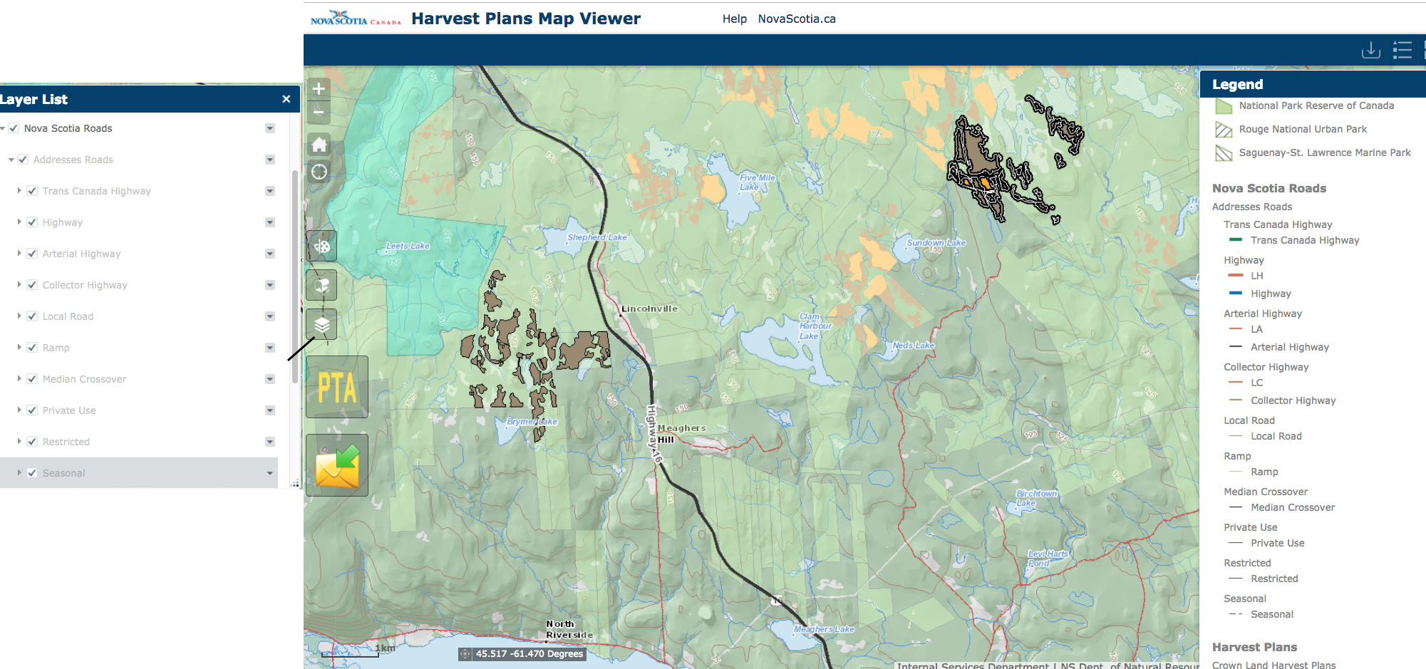
Viewing locations of Proposed Harvests
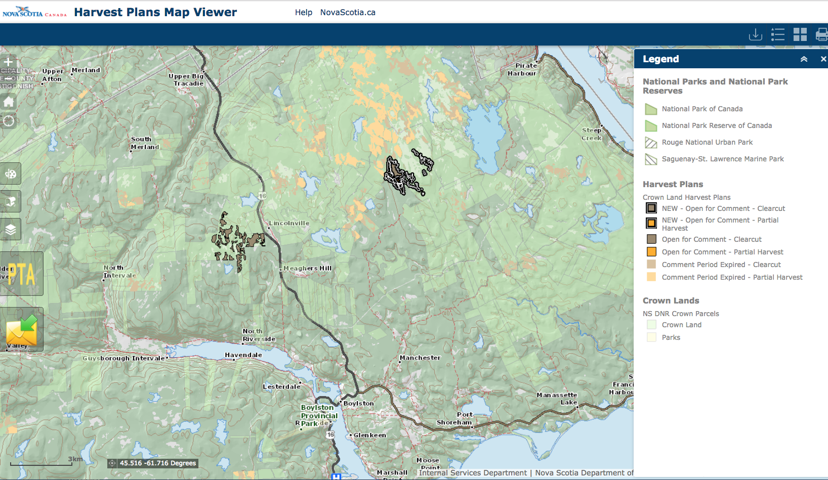
Open the HPMV, move to an area of interest, zoom in a bit and you get a view like the above by default. The patches with darkened edges are “New” proposed harvests.
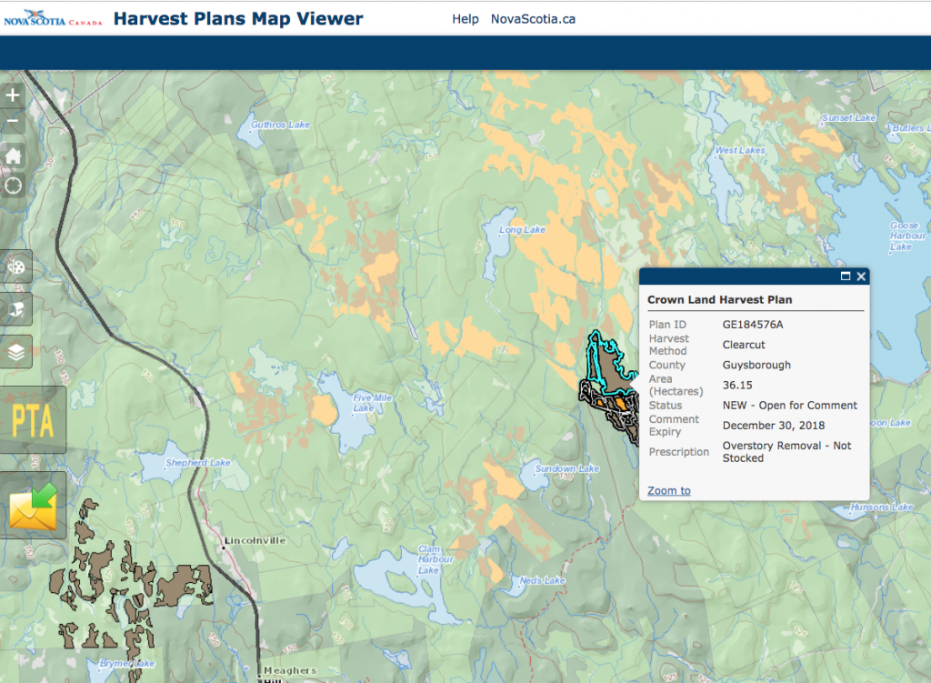
Click on a patch (polygon), in this case one with edges, and an info window comes up
Requesting a PTA
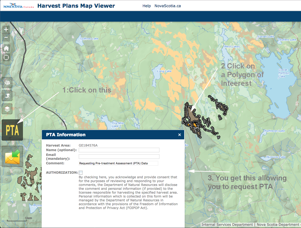
Now, if you want to get the PTA (pre-treatment assessment), click on the PTA Box at Left, then click on a polygon of interest, and this comes up (if it’s still open for comment) So you put in your e-mail address and send it off.
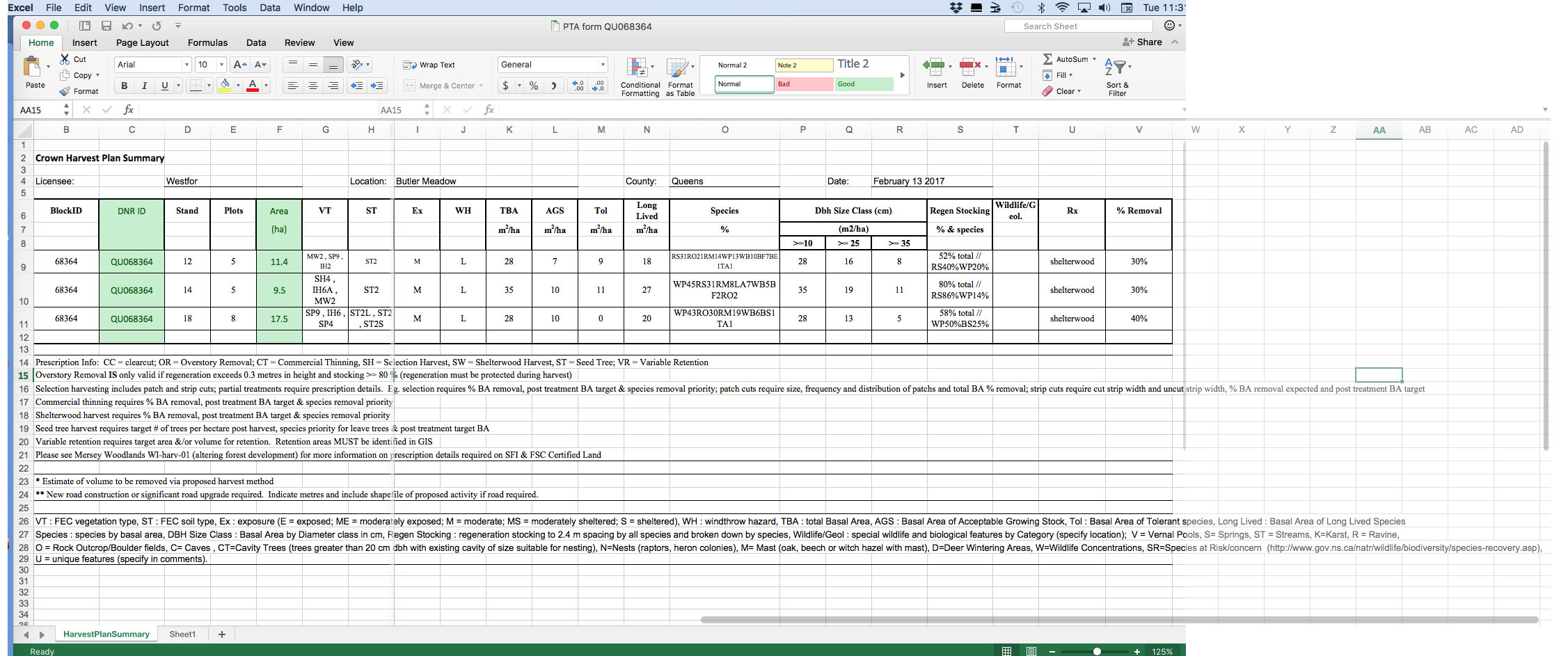
Eventually you are sent an excel file, which must be opened in Microsoft Excel (or equivalent spreadsheet program). Here is the text for the accompanying e-mail I received related to a WestFor parcel:
“The Pre-Treatment Assessment (PTA) is an analysis of data that is collected on-site in the forest using typical forest measurement techniques to determine whether or not the forest stand will support a partial harvest. These measurements include identifying tree species, diameter, height, condition of the trees, and soil type. This data is processed either manually or automatically through forest management guides (FMG) that are designed for various forest types. The FMG will determine the harvest treatment that best emulates the natural disturbance regimes to support ecological processes and to identify silviculture prescriptions that protect and/or encourage natural regeneration or identify sites for manual tree planting.
“The tree species and their condition, the amount of established regeneration, soil type, and the ability of the forest to stand up to wind disturbance have an influence on the harvest prescription. For example, shallow rooted trees on rocky soils on an exposed hillside will not support a partial harvest or thinning. These sites would be at risk of tree blowdown.
“Attached is a summary of the field data for the sites you have requested PTA data. This table shows summaries of indicators that are used in the FMGs to guide the decision making. Most of the descriptions of the abbreviations are noted below the table.
“If you have any further questions or comments, please feel to contact me by replying to this email.
“Marcus Zwicker
General Manager – WestFor Managemnt Inc.
Cell – 902 210 7073
Office – 902 530 2362
Email – marcus.zwicker@westfor.org”
You need a fair amount of specialized training (or self study) to comprehend the PTAs… they rarely provide accompanying text descriptions, no photos or anything of that nature. View Pre-Treatment Assessment (PTA) Methods and Tools by Tim McGrath (NSDNR, Feb 2017) for details of how the surveys are conducted. View Footnote for the steps involved in proposing and approving a harvest.
So then you submit your comments accordingly, in this case to MZ. It’s probably a good idea to copy other people, entities, e.g. forestrymaps@novascotia.ca
After that, it’s all pretty hazy. Sometimes, you get a response of some sort. Sometimes you do not. At least that is my experience.
If modifications to the proposed harvest are made, you may or may not be notified about it. At least that is my experience.
Here is some related info I received from forestrymaps@novascotia.ca:
- Responses to PTA requests and comments around specific proposed harvest plans will normally be provided within 10 days and will normally come from the Licensee.
- By requesting information from one parcel of a proposed harvest plan with multiple parcels, only the corresponding PTA data for that parcel is provided.
- PTA data is available upon request through forestrymaps@novascotia.ca of blocks after the comments period has ended.
Submitting Comments independently of the PTA
You do not need to go through the whole PTA route to make a comment on proposed harvests:
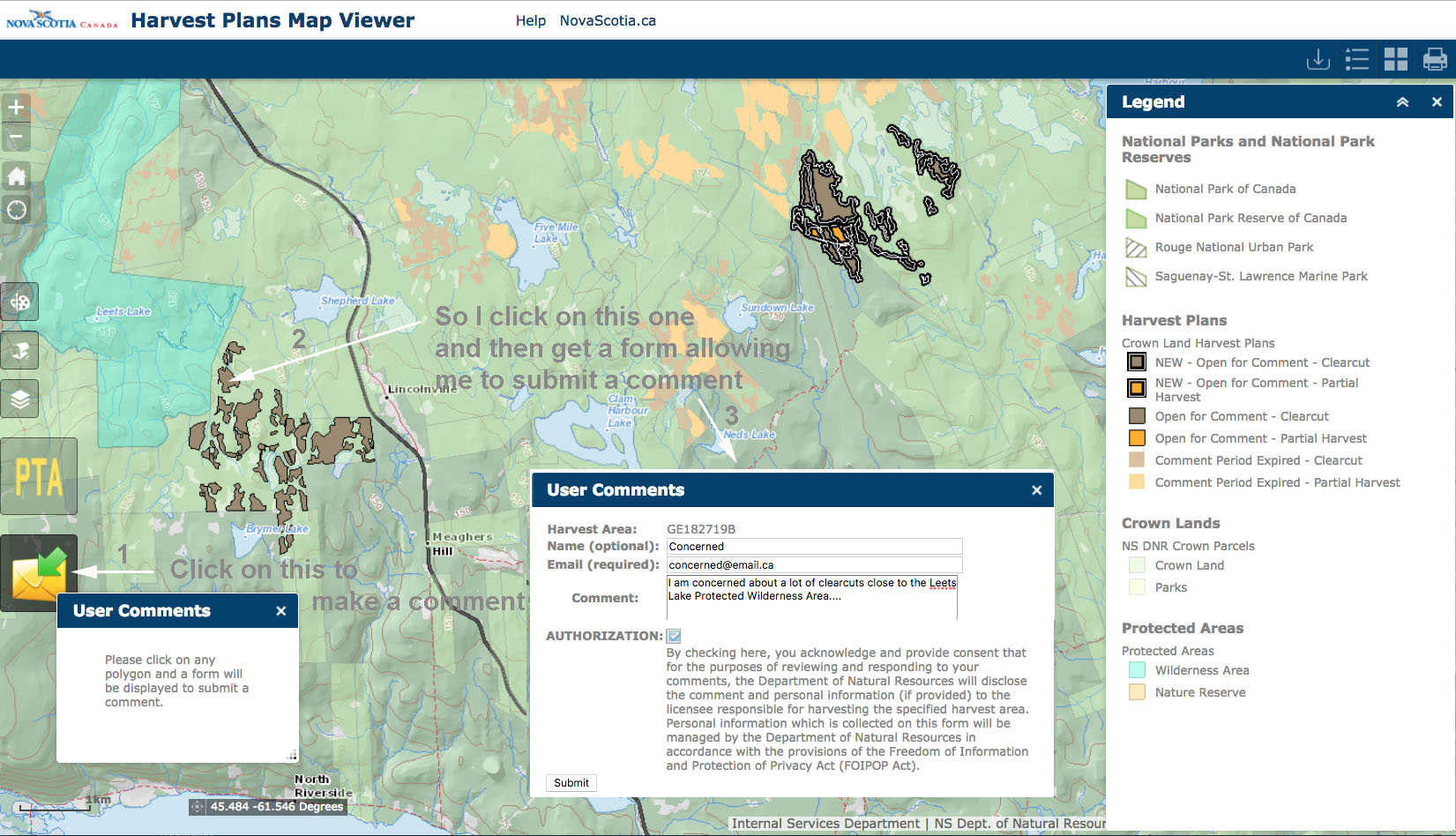
How to make a comment without going through the PTA process
To see a large version of this one, click here
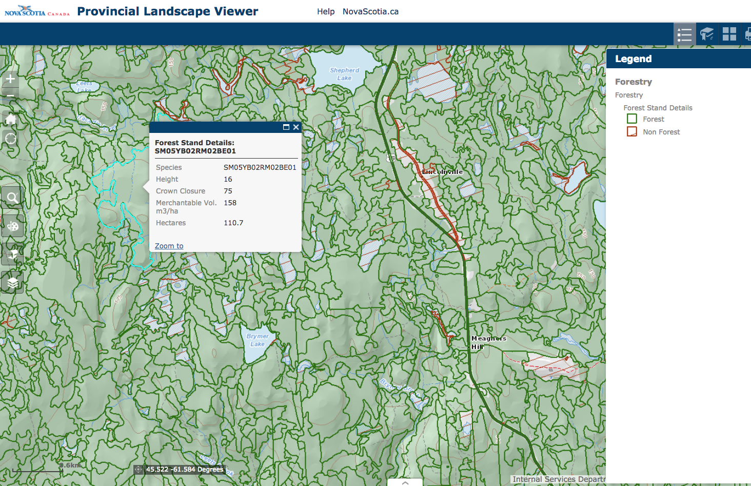
What else is on the HPMV – Protected Areas
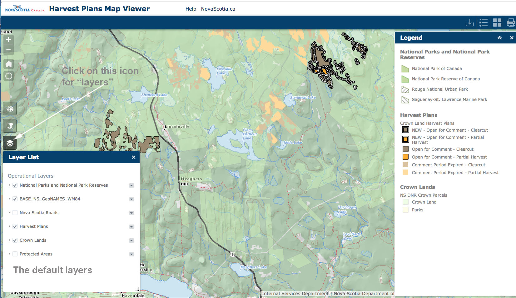
These are the layers that come up by default. They do NOT include Protected Areas
To see a large version of this one, click here
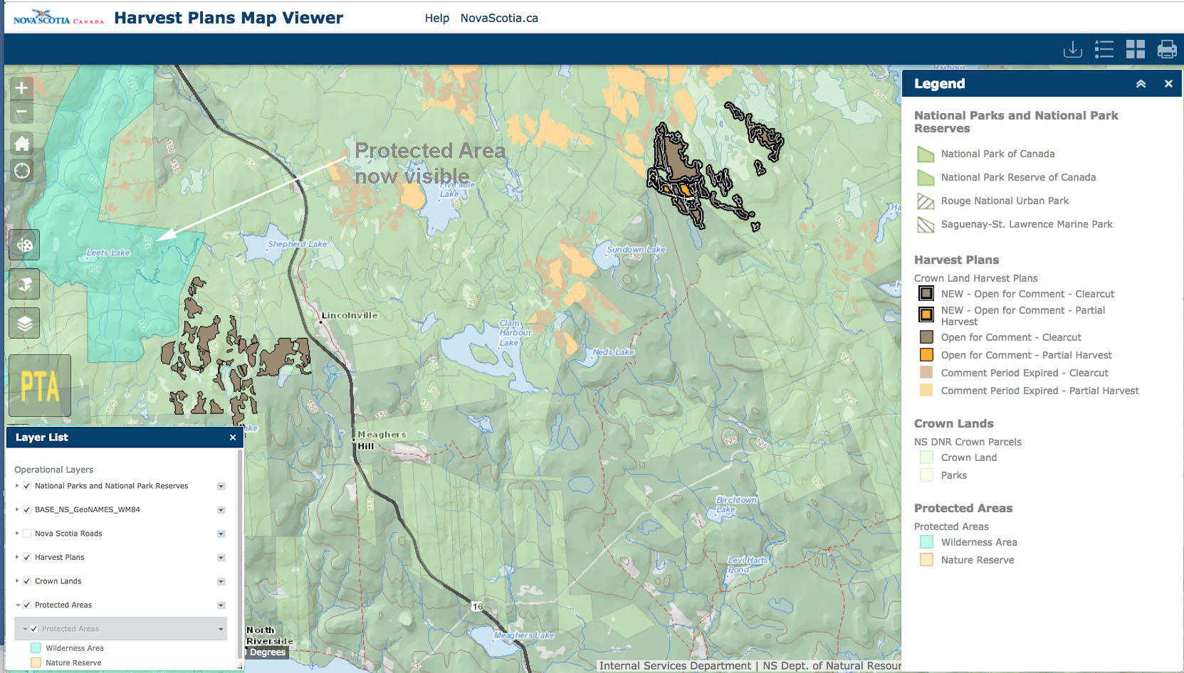
Here I have checked off Protected Areas in the layers list and now we can see a Protected Area – and clearcuts close to it! However areas identified as protected areas but not yet formally designated are NOT shown.
To see a large version of this one, click here
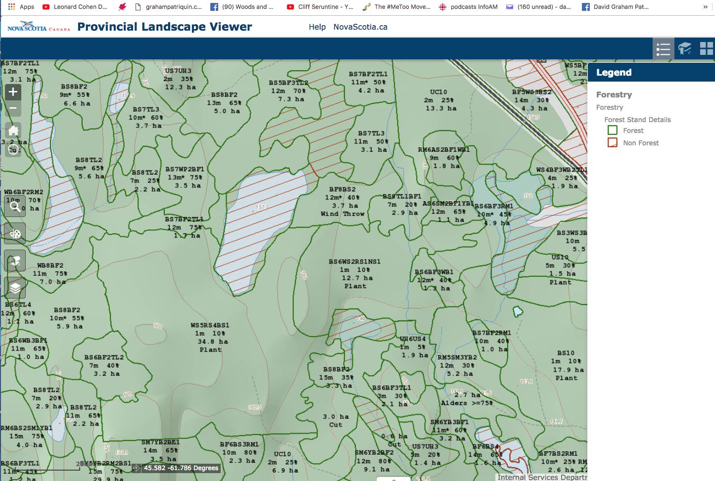
What else is on the HPMV – Roads
Here is the map with the Roads layer/all options checked
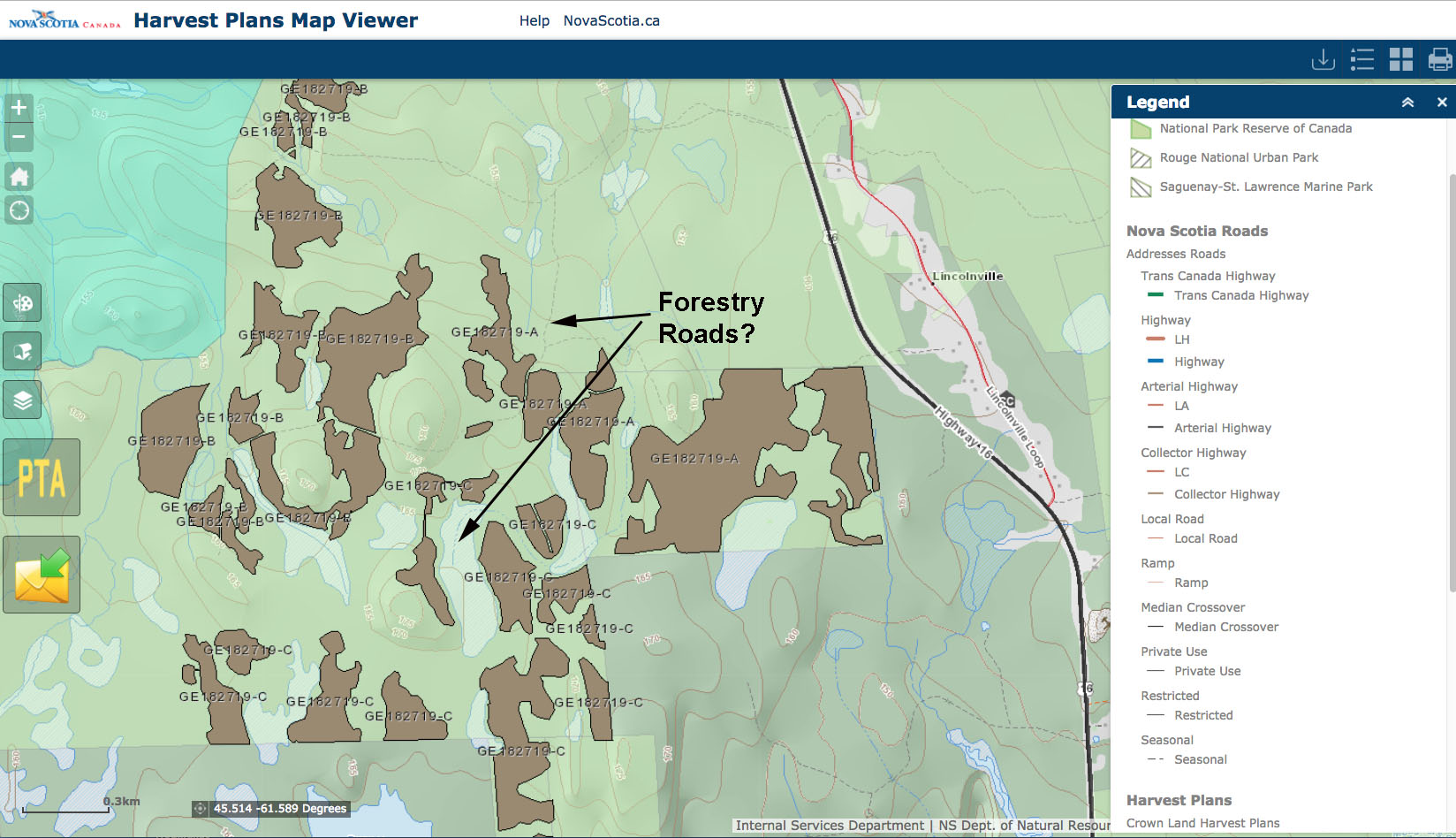
These broken lines are not explained or referenced under roads. I am guessing they are Forestry Roads. They are not Seasonal Roads, because if you unclick Seasonal Roads, they are still there. In fact if you unclick everything they are still there, so they are on the base map.
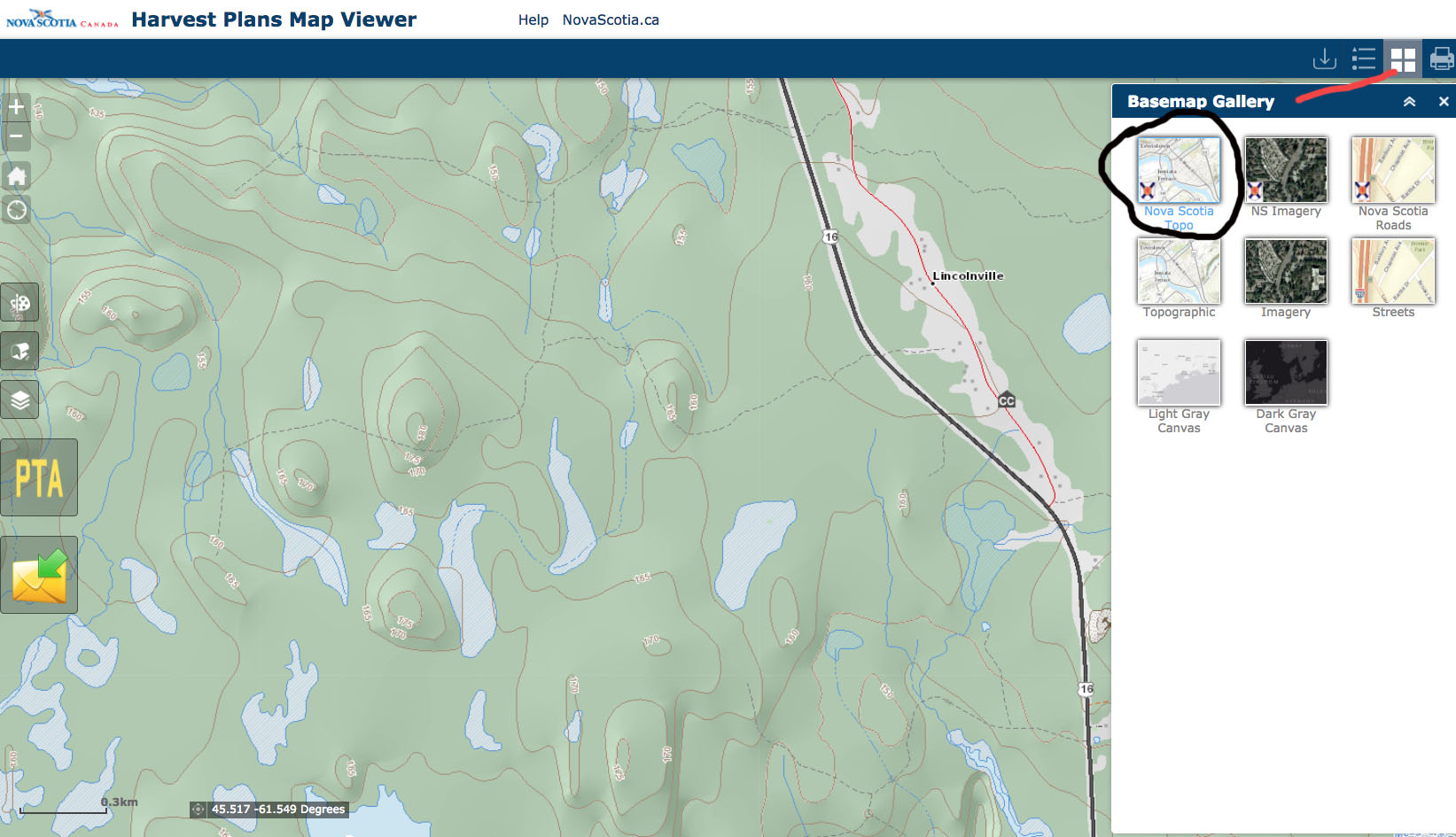
Basemap – NS Topo selected. Broken lines are still there. Some may be trails rather than roads.
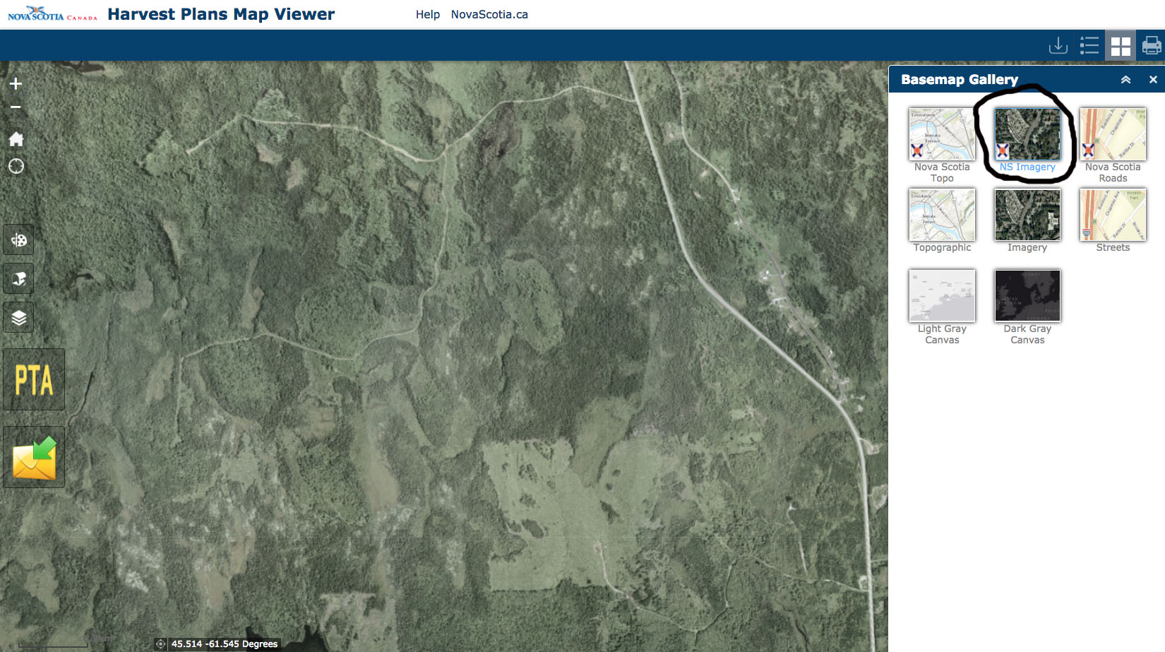
Basemap – NS Imagery selected. No date given for the imagery. The broken lines visible on the Topo Map are visible here as roads. So they must be forestry roads.
SOME OF WHAT’S NOT AVAILABLE ON THE HPMV BUT CAN BE ACCESSED ELSEWHERE
On the Provincial Landscape Viewer (PLV)
The PLV has a similar interface to the HPMV. As outlined below, there is a great deal of info on it that is relevant to forests and forestry in NS. See Codes. Some of the codes I was able to find only in a Photo Interpretation Specifications.
View Help Page for the Provincial Landscape Viewer. Also see ELC – Ecological Land Classification for some of the codes.
Wildlife Layer on the PLV
This layer shows what is known – or at least considered by L&F – in regard to wildlife habitat in an area.
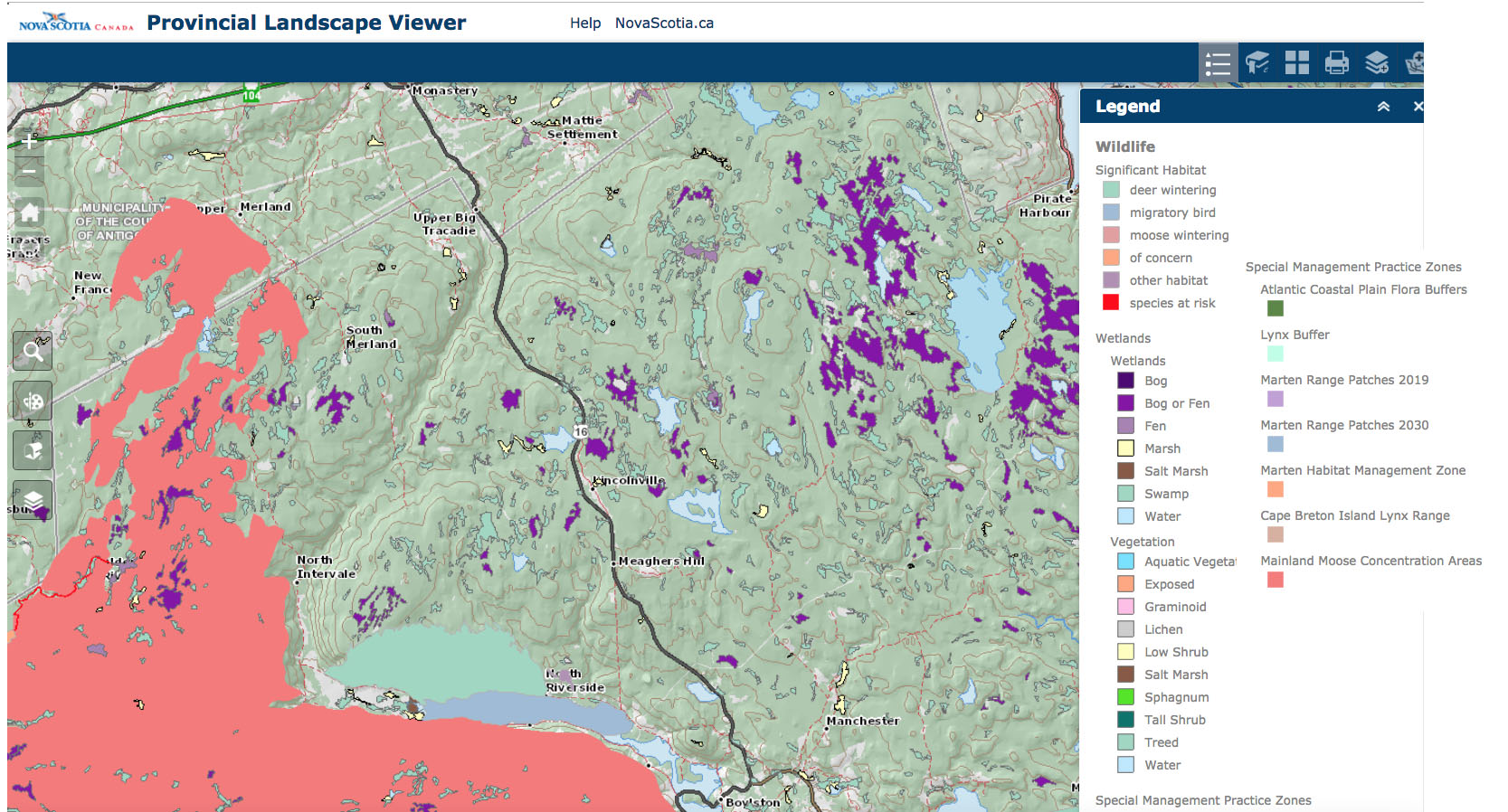
There are no species at risk visable for this area. Significant Habitats for Moose Wintering, Deer Wintering and Migratory Birds are identified here (bottom left area)
Old Forest Policy on the PLV
Areas set aside under The Old Forest Policy are to be “maintained and left to mature naturally with no management intervention.” – PLV Help Page
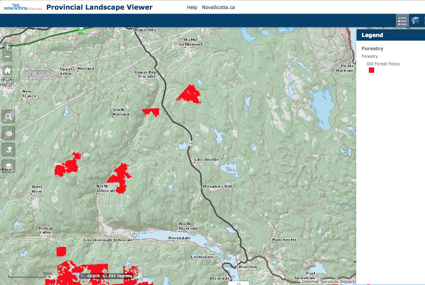
From the PLV Help Page: The old forest layer maps the locations of stands that were selected under the Interim Old Forest Policy of 1999 (novascotia.ca/natr/library/forestry/reports/Old-Forest-Policy-2012.pdf). The forests identified in the layer consist of old growth stands, as well as mature stands set aside to restore old growth. According to the policy these stands will be maintained and left to mature naturally with no management intervention. Most of the forests in this layer are not old growth.
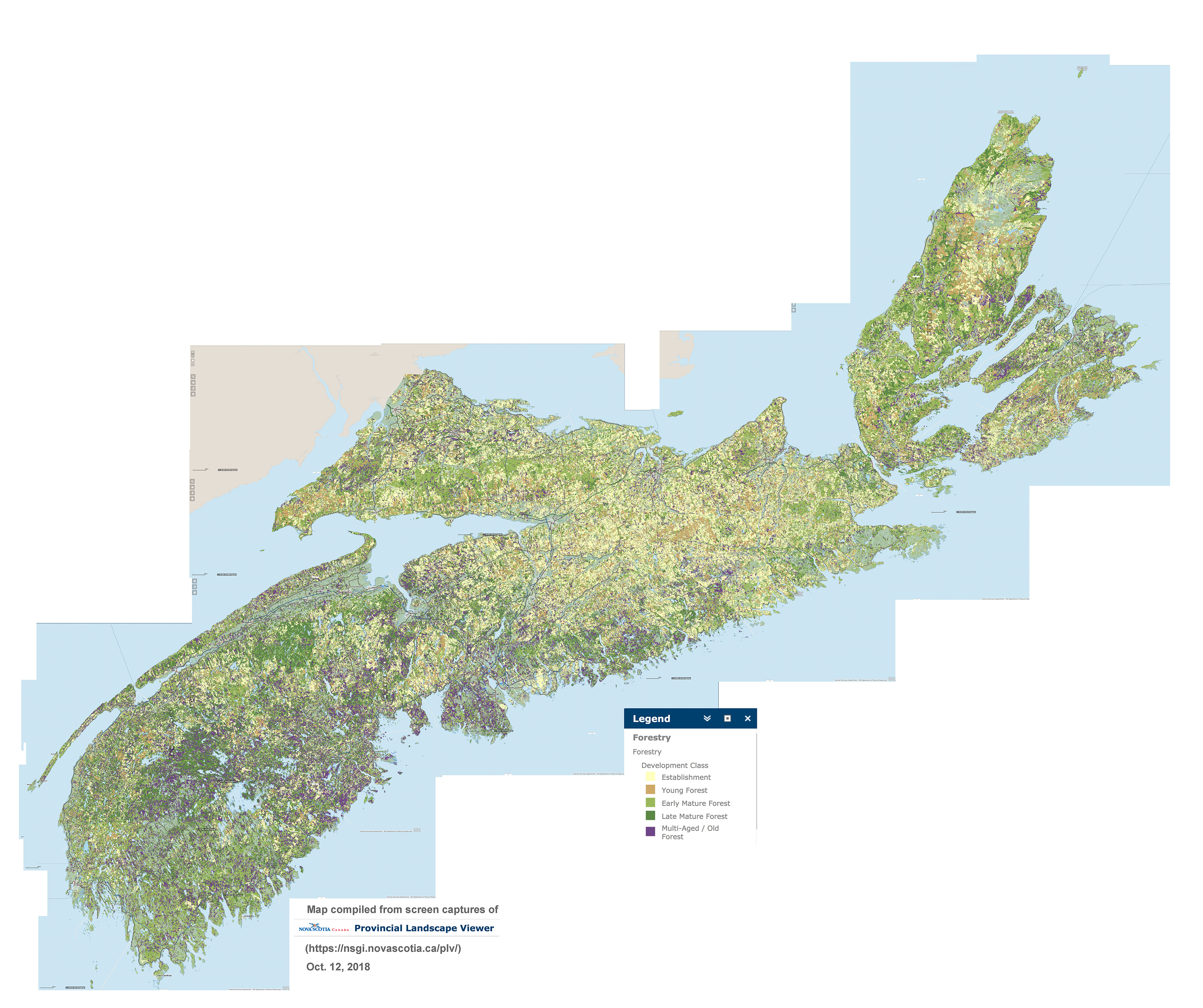
Forest Development Class layer on the PLV
I see this as an exceptionally relevant Layer that really should be on the HPMV. Most of the light yellow areas – Establishment class – are recovering from recent clearcuts so it illustrates the intensity of clearcutting. The darker layers are the older forest, with the purple being Multi-Aged/Old Forest – that’s where the biggest wood volumes occur, also the oldest forest stands. Contrast this area with a much more lightly harvested area in SW Nova Scotia, and you can understand why Industrial Forestry is so keen to harvest in SW Nova Scotia!
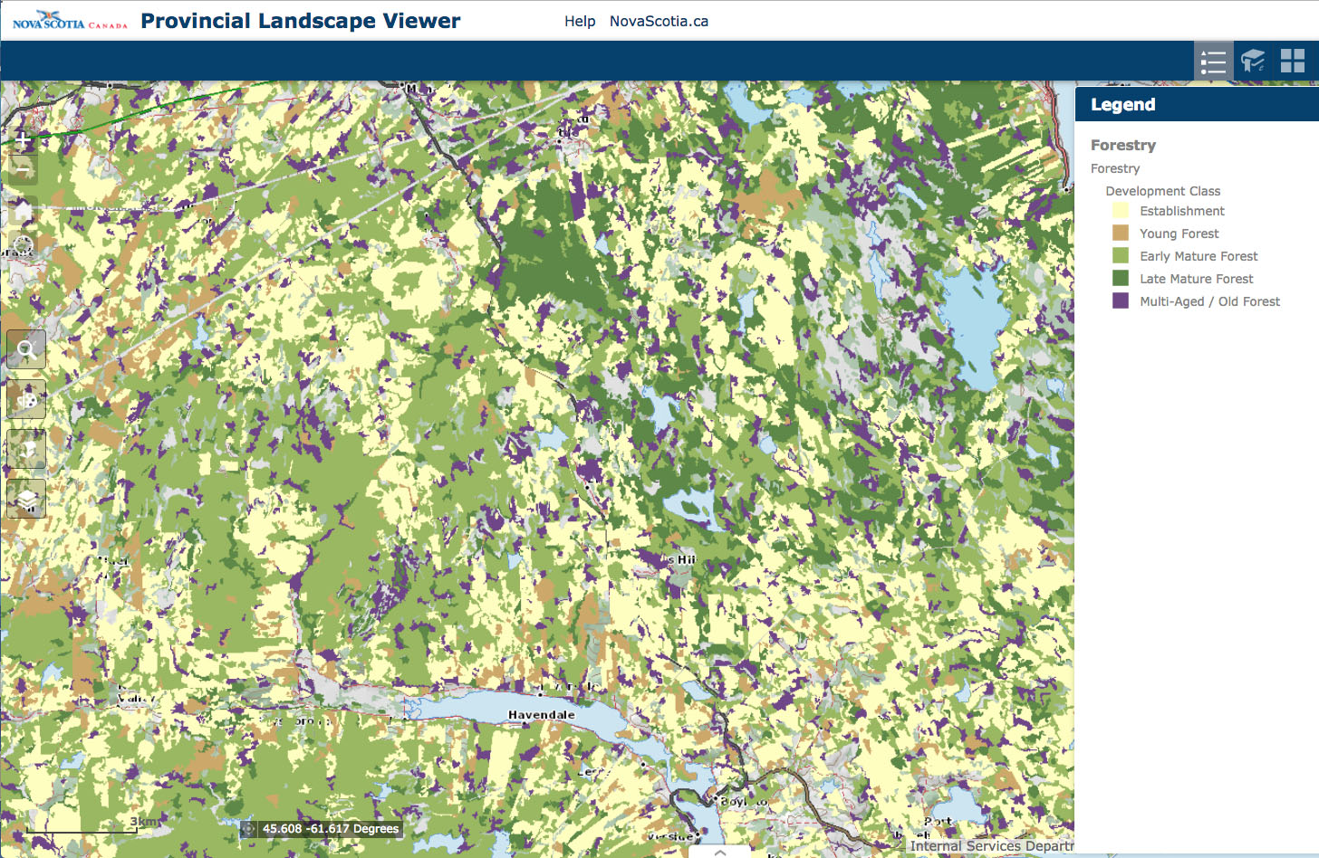
From the PLV Help Page: This layer describes the structure of forests as they age and grow (e.g. forest establishment, young forest, mature forest).
Four development classes describe the structure of forests as they age and grow. Assignments are based on stand height:
· Establishment (Height 0-6m): Influx of new growth following a stand initiating disturbance, and characterized by a high diversity of forbs, shrubs, and tree regeneration.
· Young Stem Exclusion (Height 7-11 m): Young developing tree canopies characterized by vigorous self thinning, crown differentiation, and competitive exclusion of many individuals.
· Mature (Height > 11 m): Stands dominated by upper canopy trees with full differentiation into dominance classes. Canopy gaps are soon closed by neighbouring tree growth.
· Multi-age and Old Growth (Age 999 and Old Forest Policy): Overstory exhibiting a variety of crown sizes and canopy densities. Canopy gaps are persistent promoting multi-layered understory development and recruitment to the overstory.
One drawback of the PLV is that you cannot see a map with these layers for the province as a whole – you have to zoom in before it comes up. Here is a map I created for the whole province by combining screen captures at the zoomed in level:
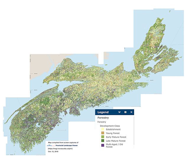
Distribution of forest in 5 development stages across Nova Scotia, compiled from NS Landscape Map Viewer. Purple = Multi-aged/Old Forest. View larger versions of the map: 2000 px | 4000 px.
(You may have to Save the larger image and open it on your device to view at full size).
Pick a large version and do a sweep across the province to see where the heaviest clearcutting had been conducted, and where most older forest remains.
IMPORTANT UPDATE June 7, 2022:
Sometime after 2019, L&F changed the Forest Development categories, collapsing Early Mature and Late Mature into one category (Mature).
Forest Volume Class layer on the PLV
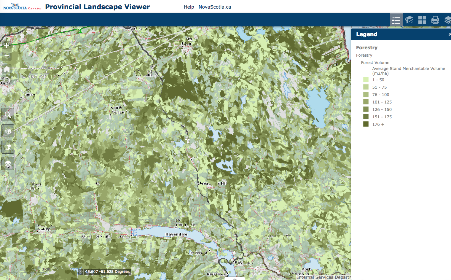
This layer “Identifies the average total merchantable volume categories (m3/ha) for forest stands.” – PLV Help Page. The overall pattern is pretty similar to patterns discernible on the Forest Development Layer
Forest Species and Stand layers on the PLV
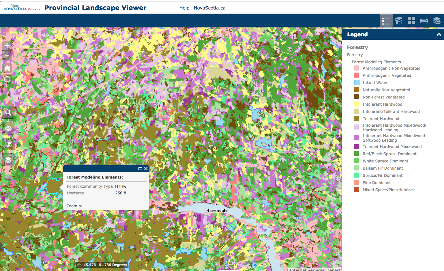
“This is a coarse characterization of the occurrence and relative abundance of tree species associations within the forested landscape and is built upon the Nova Scotia Forest Inventory. The focus is on dominant tree species associations. The Ecological Landscape Analysis guide outlines twelve forest communities: HTHw, HITHw, HIHw, MTHw, MIHwHS, MIHwSH, SrSbSDom, SwSDom, SbFDom, SSpbFDom, SPiDom, SMHePiSP. As well, there are five classes to represent non-forest inventory types: ILW, AV, ANV, NNV, and NFV.” – PLV Help Page

“This layer identifies the leading forest species.” – PLV Help Page
Forest Treatment Details: “The treatment details layer records the location and type of silviculture treatments in the forest. Sources of information include: GPS collected data submitted under the Wood Acquisition Plan program, Crown land silviculture data collected from various sources, including paper plans, string box and compass, aerial photography and GPS and historical pre-GPS silvicultural features. Note that all treatments are not recorded. For example, it is known that not all treatments on private land are reported to the Wood Acquisition Plan program.” – PLV Help Page
The next image zooms in a further in the Forest Treatment Details layer, giving info for each polygon:
Ecological Emphasis layer on the PLV
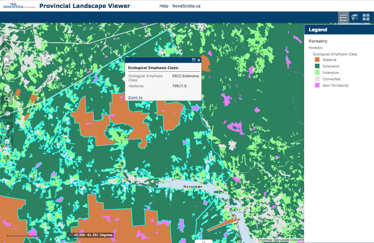
Ecological Emphasis Class: “Four levels of conservation are defined based on the degree to which the conservation of natural conditions is emphasized in the management practices and policies applied to the land. All lands are assessed at the stand level of the GIS forestry database layer, and assigned to one of the four ecological emphasis classes.” – PLV Help Page
Ecological Land Classification on the PLV
“Ecological Land Classification layers grouping. For more detailed information on the DNR Ecological Land Classification system, refer to Ecological Land Classification For Nova Scotia – Revised Edition 2005. – PLV Help Page
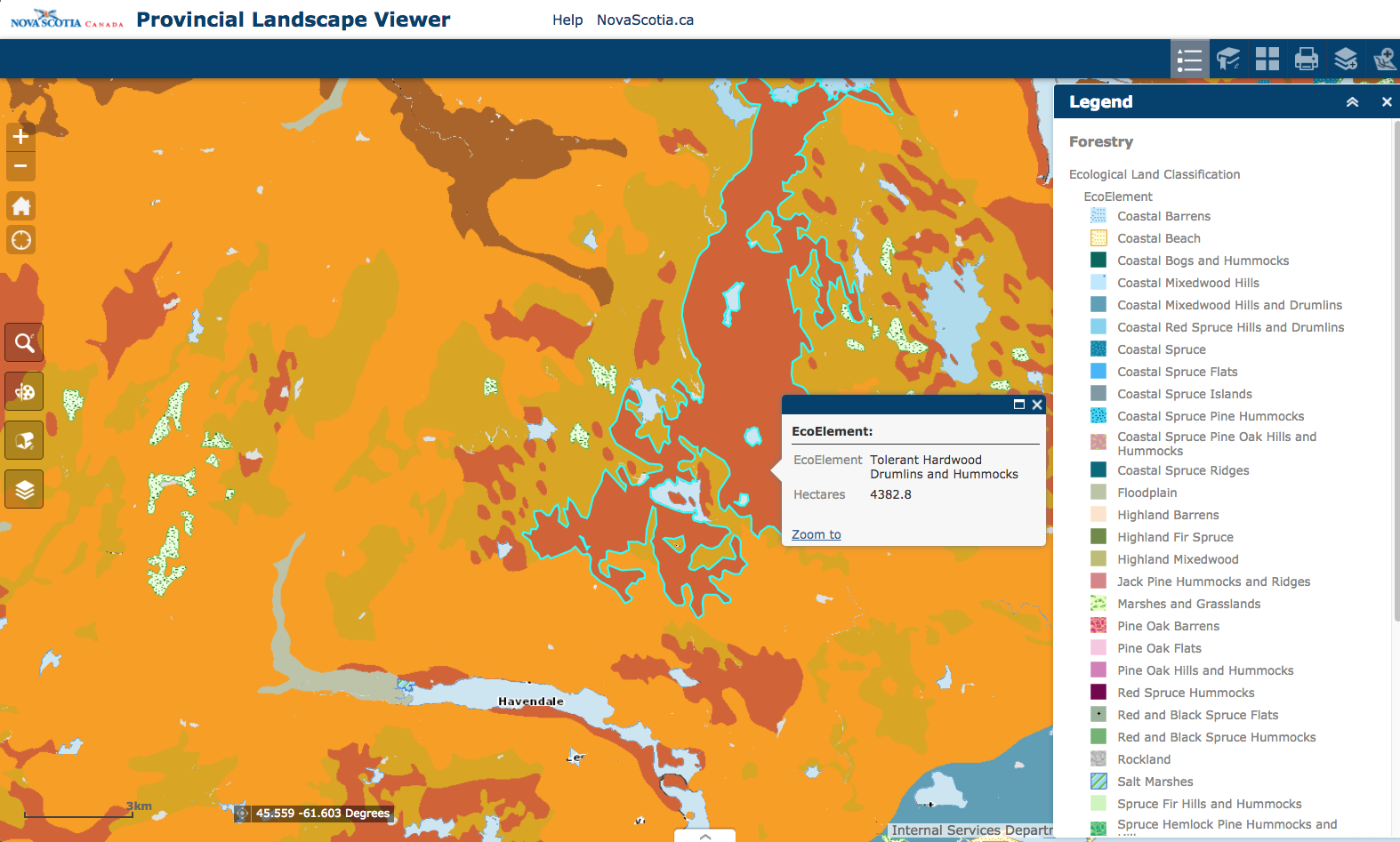
Ecological Land Classification – EcoElement “A landscape ecosystem containing characteristic site conditions that support similar potential vegetation and successional processes. Elements were mapped by combining ecosections with similar climax vegetation and natural disturbance interpretations.” – – PLV Help Page
NSE: Watersheds
It is very pertinent to know where harvests are taking place and the intensity of harvests within a watershed. Watersheds are not given in the HPMV, nor as far as I can see in the PLV. They can be found on an interactive Nova Scotia Environment map:
1:10,000 Nova Scotia Watersheds
Boundaries and ID info given for “1:10,000 watersheds for Nova Scotia. Contains primary, secondary, tertiary and sub-tertiary watersheds”. This map tool is not very user-friendly, but the only one I know of that gives details for individual watersheds and subwatersheds in NS. The Parks and Protected Areas map tool cited below provides more readily accessible outlines of secondary watersheds, but gives no details for them.
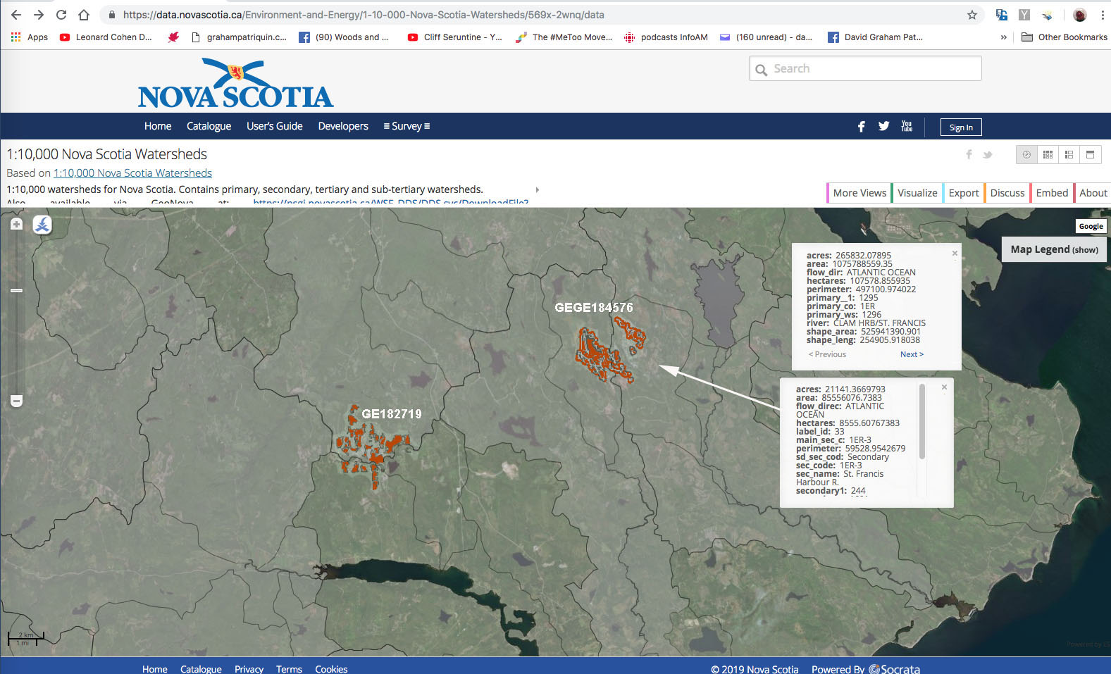
I took a screen capture and then overlay the two areas of proposed harvests viewable on the the HPMV. Boxes give info on the Primary Watershed, and data for one of the Secondary or sub-Watersheds.
Secondary watersheds are also identified and data are given in the NSE Lake Survey program interactive map
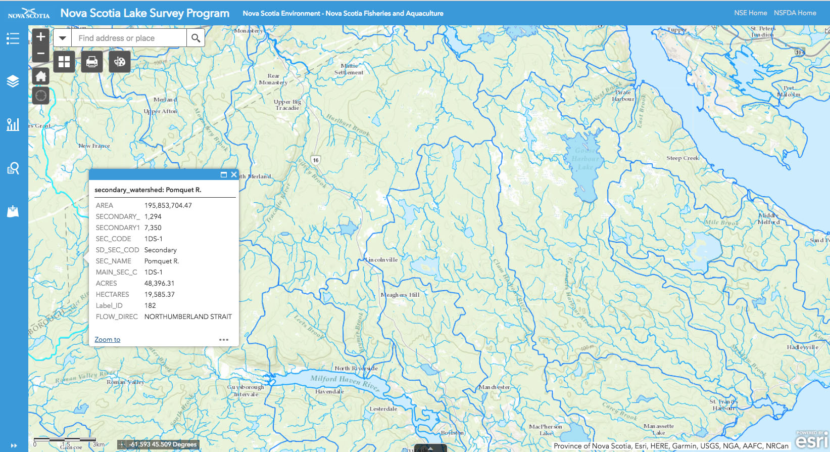
The secondary watersheds on this map are larger units than those given in the 1:10,000 Nova Scotia Watersheds map. Streams are much more clearly identified, and data for lakes are given in the NSE Lake Survey program interactive map
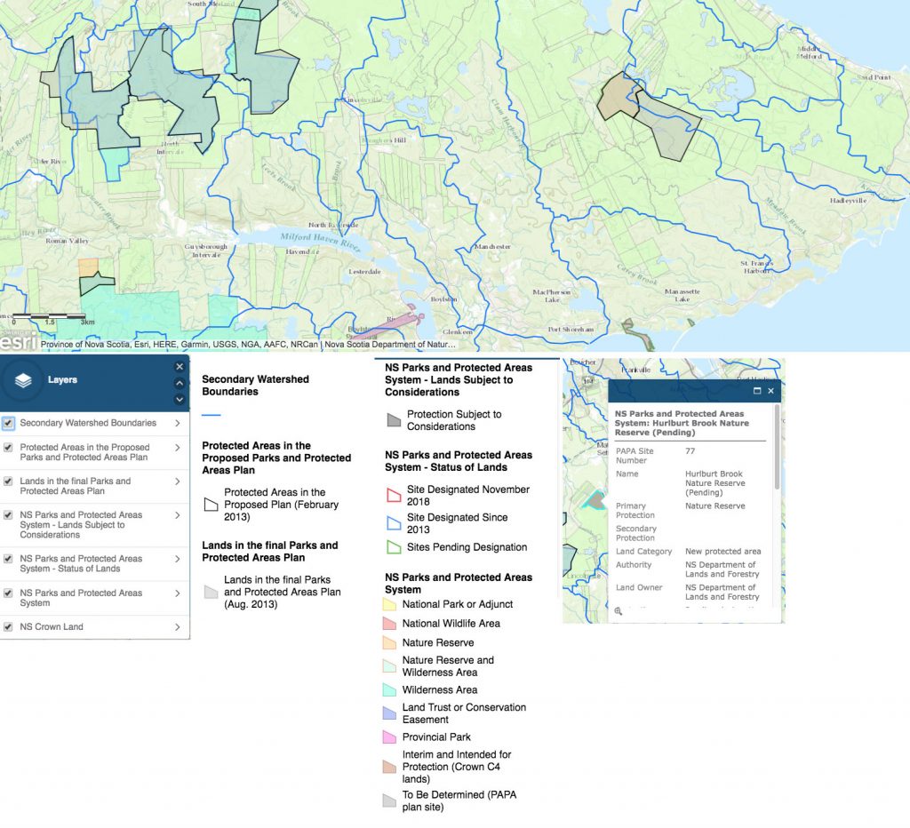
Parks and Protected Areas
While you can see Protected Areas on the HPMV, you cannot see protected areas that have been identified but are awaiting formal designations. For that, you need to go to the Nova Scotia Parks and Protected Areas Interactive Map
You can view:
-secondary watersheds
-sites in the proposed parks and protected areas plan (Feb 2013)
-sites in the final parks and protected areas plan (Aug 2013)
-sites in the final parks and protected areas plan still to be designated or subject to considerations
-areas considered protected
-provincial crown land
This site is a more readily accessible place than the site above to view the borders of secondary watersheds also, but no stats are given for them.
To see a large version of this one, click here
Wind exposure and Soil Type layers on the Pre-Treatment Assessment Reference Viewer
There is no Help Page for this one. Fear of blowdown when they cut wide roads into forest stands is a major reason for clearcutting under the current protocols. (Better to clearcut than leave it standing, apparently).
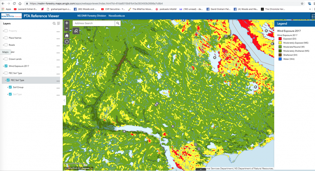
Wind exposure layer. To see a large version of this one, click here
Currently, it seems there is little attention given to soil types in the PTA Process, although I stand to be corrected on that one. Use the map to identify a soil type for a particular area and consult Forest Ecosystem Classification for Nova Scotia Part II: Soil Types (2010) for information about that soil type.
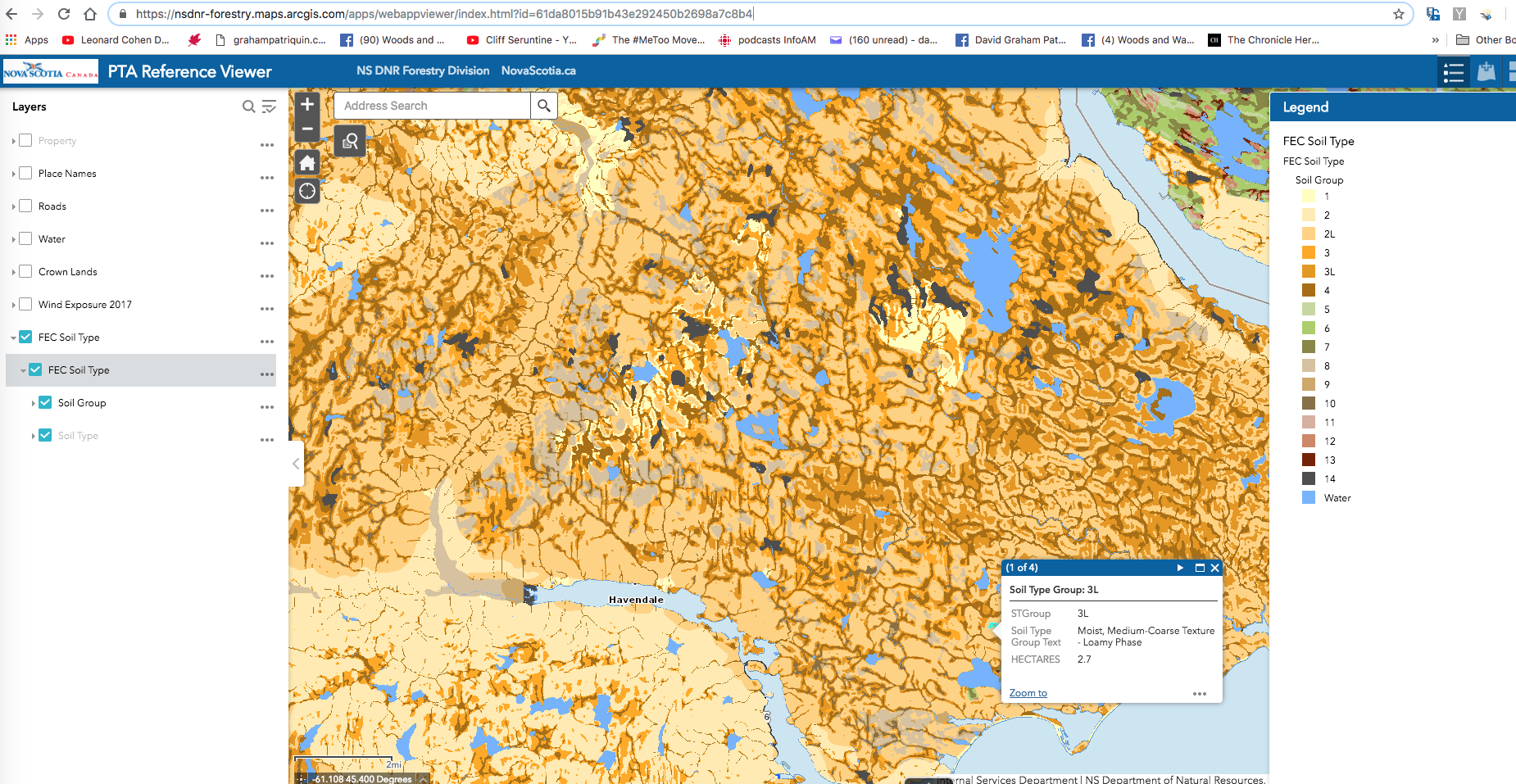
FEC Soils Layer. To see a large version of this one, click here.
Satellite View by Month in Planet Explorer
Planet Explorer is a powerful interactive map tool showing satellite images over short intervals which can be useful for tracking road-building, harvests etc. I learned about this tool recently from Annapolis Valley folks who were trying to find out when a new road into a proposed harvest area was built.
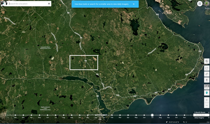
Click on the image to zoom in and see landscape changes June through October, 2018
COMMENTS (WISHLIST)
Modified Jan 4, 2019
I wish… for the sake of increased transparency, increased confidence in the public processes, and increased consideration of the landscape level context of proposed harvests, the following:
– The default setting in the HPMV includes the Protected Areas layer. Currently, it includes 4 of the 6 Operational Layers, why would it NOT include Protected Areas? That it doesn’t conveys a sense that they (L&F) don’t really want people looking at where proposed harvests lie in relation to Protected Areas. Including them does not clutter the maps significantly.
– Secondary watersheds are available as an optional Operational Layer in the HPMV. This seems a “no-brainer”, given Nova Scotia’s commitment in 2010 to Integrated water Management and “Using the watershed as a unit for analysis…so we can understand how impacts from both human and natural activities are felt and how they can accumulate (Water for Life doc, 2010).
– Approved and executed harvests are retained on the HPMV. They were retained initially, but a message on Aug 2, 2017 cited “Removal of plans which have already been harvested”. I wrote to Ryan McIntyre at NSDNR about it; he replied: “Thanks for the input… We considered leaving the cuts, but archiving them, and may go this route in future, but for now, so as not to clutter the map we decided to remove the old plans completely.” The old harvests could be put on a separate layer (like anything else) which would not clutter the default view.
– The HPMV includes layers available on the PLV; OR (probably simpler), that the Harvest Plans Operational Layer is available on the PLV. These two interactive mapping systems appear to be operating on the same or parallel platforms, so I am guessing that making the Harvest Plans Operational Layer available on the PLV would not be a big deal technically. It would a huge improvement overall in access to information and transparency, and it would allow landscape level aspects of proposed harvests to be examined much more readily. There is not much evidence, none really, that landscape level considerations come into harvest decisions now. This could be a significant first step. Then related questions could be added to the PTA process, such as how much of the secondary watershed(s) – assuming those could also be introduced as a layer on the PLV – in which the proposed harvests lie is in the Establishment Stage?
– Some version of Keys et al. 2016 Fig 3 (soil clay, soil carbon soil BS, soil depth, substrate weatherability) be included as an Operational Layer on the HPMV. Dr. Keys will (may) say they don’t have enough data yet to do that (it’s an explanation he has made on why they haven’t moved faster to implement nutrient budgeting as part of the PTA). But they could plot average values for each watershed or secondary watershed from the data they have now, and show those average watershed values; soil BS (Base Saturation) is especially relevant.
 – Any long term harvest plans that companies/WestFor have shared with government should be made available in conjunction with “New” Harvests posted on the HPMV. We are told that these proposals come up one by one, but there are larger, longer term plans that are pertinent to landscape level planning. Clearly those should be posted and be reviewable by the public in the same way that individual blocks/parcels are currently. The page introducing the HPMV is titled “Harvest Operation Maps” but lacks any mention of maps that show longer term plans. Obviously those exist (one I have seen is titled “Operating Plan”) but are kept hidden view and are not mentioned.
In regard to PTAs, I wish…
– The PTAs are made available directly on the HPMV. (Why should one have to request them? They have already been conducted and reported as a PDF document and could be provided via a link when you select the PTA icon.)
– Coordinates for the observations, including all sampling sites are provided. This would provide a greater sense of transparency, and facilitate access to precise sites of the PTAs for individuals or groups wishing to do their own assessments.
– The PTA includes an estimate of the % of a secondary watershed that will be harvested in a proposed harvest and for all previously executed harvests and harvests in progress over the last 5+ years.
– The PTA includes an estimate how much of the secondary watershed(s) in which the proposed harvests lie is in the Establishment Stage as revealed in the PLV.
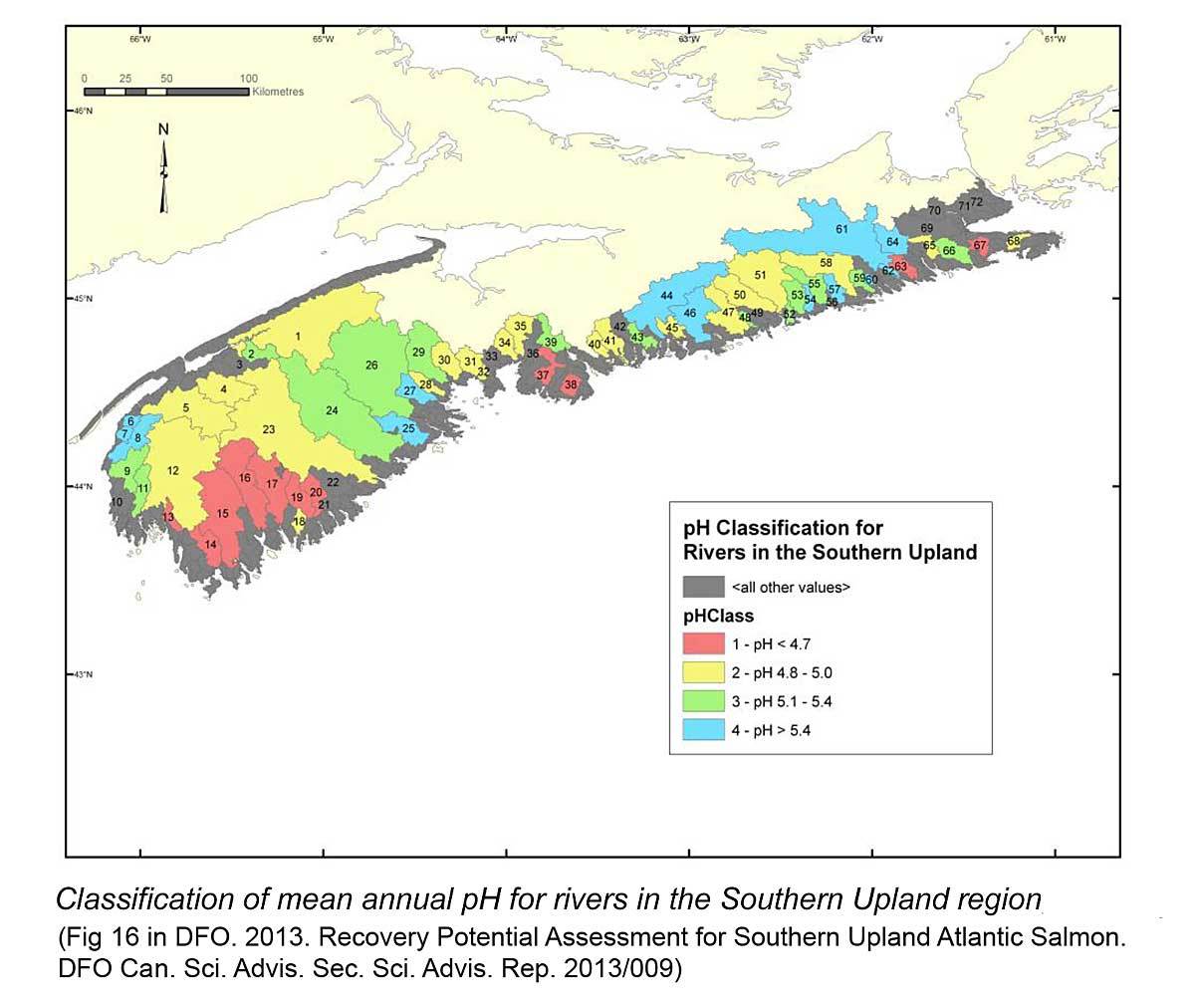
– The PTA indicates whether proposed harvests lie in a pH-stressed watershed
– The PTA includes a set of questions related to possible presence of Old Growth in patches smaller than whole polygons to be answered in text form by the observer, e.g.:
– Give species and diameters for the 5 largest trees for each sampling point
– Did you observe any patches (versus whole stands) either in the sample areas or outside of them that you might describe as Old Growth
– Give coordinates, and approximate size of the patches
– What features of Old Growth were present (check list provided)
– Provide some photos
More… (‘workin on it)
—————-
FOOTNOTES
Steps involved in proposing and approving a harvest.
As described by NSDNR spokesperson Bruce Nunn to journalists Linda Pannozzo (View Testing the Limits: Critical Boreal Felt Lichen Habitat in Halifax County Slated to be Wiped Out, Halifax Examiner March 10, 2017):
1. The Licensee [in this case Northern Pulp] identifies a proposed harvest area and identifies any sensitive features requiring mitigation with data available to them.
2. DNR’s Integrated Resource Management or IRM Teams review the harvest plan to determine if any harvesting can occur in the planned area.
3. The Licensee proceeds with Pretreatment Assessment and any field surveys required (i.e. BFL surveys) and refines the plan based upon information gathered.
4. The Licensee may post the block to the HPMV (Harvest Plans Map Viewer) at this point.
5. The Licensee submits the refined plan to DNR for a comprehensive review conducted by the IRM team. All available data on sensitive features are referenced during the review and other DNR professional staff consulted if required.
6. The IRM Team reviews the proposed plan and rejects, approves or approves with conditions (i.e. changes required). The plan may be field audited by DNR.
7. The plan is posted on the HPMV if not posted at step 4.
8. Public comments are addressed and changes made if required.
9. If the area is approved, the licensee is notified.
Subsequent to that response, NSNDR changed the Home page of the HPMV, I think some time in 2018, to describe the steps:
Harvest Operation Maps
There are four main steps in the review of proposed harvest areas on Crown lands.
Step 1. The Crown land Licensee develops proposed harvest areas and prescriptions based on Pre-Treatment Assessment (PTA) and the Forest Management Guides (FMG), subject to all requirements for operating on Crown lands.
The Pre-Treatment Assessment (PTA) is an analysis of data that is collected on-site by a forest professional who is trained and certified to carry out PTAs. PTAs use typical forest measurement techniques in order to determine the most appropriate forest management treatment for each site. These measurements include identifying tree species, diameter, height, condition of the trees, and soil type. This data is applied through forest management guides (FMG) which are based on decades of forest research and are designed for various forest types.
To learn more about the PTA and the FMG please visit https://novascotia.ca/natr/forestry/programs/timberman/pta.asp.
Step 2. Department of Natural Resources (DNR) resource management professionals review every proposed harvest plan as part of the Integrated Resource Management (IRM) review process and determine if the plan is appropriate and meets all requirements for operating on Crown lands. The IRM team considers many things including (but not limited to): the provincial strategic forest management plan, property lines and land ownerships, adjacency to protected areas, wildlife habitat, geological information, known recreational activities, areas of significance to Mi’kmaq, and requirements for Special Management Practices (SMP).
To learn more about SMP please visit https://novascotia.ca/natr/wildlife/habitats/terrestrial/
Step 3. Each proposed harvest area on Crown land is posted on the Harvest Plan Map Viewer (HPMV), an interactive web viewer, that enables the public to view and comment on harvest plans. The viewer contains tools that enable the user to send comments or a request for a PTA for specific harvest areas. If you send a comment you will receive a notification that your comment has been received. All comments go to the appropriate Crown land licensee with a copy to DNR staff. Responses will normally be provided within 10 days and will normally come from the Licensee. Each harvest plan on the HPMV also includes a closing date for public comments, which is 40 days after the harvest site is first posted. Harvest plans that are new to the map, open or closed for comments, the area of the proposed plan, as well as the planned harvest method and prescription are all identified on the HPMV. Maps on the HPMV will be updated on an approximately ten-day cycle.
To go to the HPMV please visit https://nsgi.novascotia.ca/hpmv/
To be notified when new harvest plans have been added to the HPMV, please add your contact information here: Sign up for map-update notification.
Step 4. Crown Land Licensees are notified if the proposed harvest plans are approved or if changes are required following the public comment period and an evaluation by DNR senior management.
Plan approval does not indicate that harvesting will occur immediately. When harvest plans have been approved, the Licensee will incorporate that into its operational schedules.
———–