
Also view Land Base
Afforestation is the establishment of a forest or stand of trees (forestation) in an area where there was no previous tree cover.
In the responses to questions posed to NSDNR from the Halifax Field Naturalists in 2017:
Question 1: Does NSDNR have good figures for forest cover over time in Nova Scotia that can be shared with us? Has there been significant loss in total forest cover over the last 50 years? Is deforestation an issue?
DRN response:
The data shows that the area of forest cover has actually increased over the past 100 years, including over the past 50 years. The Fernow (1912) forest inventory report was the first comprehensive inventory of land and forest for Nova Scotia (although it only recorded forest, non-forest and agriculture). In 1958 the Department completed its first full inventory of the province. Department inventories since the 1960’s are available on-line. Area estimations have improved over time due to aerial and satellite imagery, and computer geographic information systems technology.
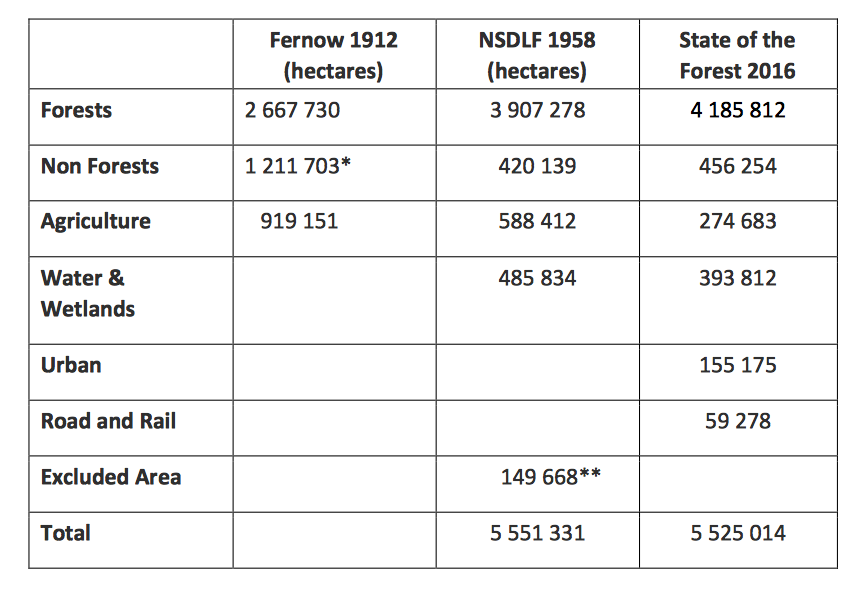
* Fernow included old burns, barrens and recent burns in this category. ** Excluded area was Cape Breton H.N.P. and all the area north of the park.
Figures for the area of deforestation – the conversion of forest land to non-forest uses such as agriculture, utilities/transportation corridors and development, in Nova Scotia, has not been calculated.
The table above shows some deforested lands of the past are returning to forested conditions due primarily to agricultural land abandonment and fire suppression.
There is no evidence that deforestation is an issue as a consequence of forest management. Some of the most recent deforestation has occurred in the Cape Breton Highlands ecoregion primarily affecting the National Park and the Pollets Cove Wilderness Area. This resulted from the continuing hyper abundance of moose following the spruce budworm outbreak, which has converted most of the upland balsam fir ecosystems to grasslands. NSDNR has been supporting Parks Canada in restoration initiatives as they seek to address associated biodiversity concerns. Fortunately, this same level of deforestation has not occurred in the region south of the park which is under forest management.
It appears that harvesting, silviculture, and reforestation activities along with the logging road networks and associated hunter access has allowed these ecosystems to remain forested, thus maintaining habitat for endangered lynx, marten, and Bicknell’s thrush among many other species dependent on these ecosystems. This highlights the potential of integrated planning to direct a variety of land management approaches to achieve balance and optimize the roles that each can play.
Related:
Field Spruce in Nova Scotia
1957 publication by M. H. Drinkwater. “The spread of white spruce upon the abandoned farm lands in Nova Scotia has been rapid since about 1890. Although the individual stands usually cover less than 30 acres, the total area is estimated to be about one-half million acre.” See also Old Field Forest Group under the Forest Vegetation Types.
Soils and Agriculture in NS
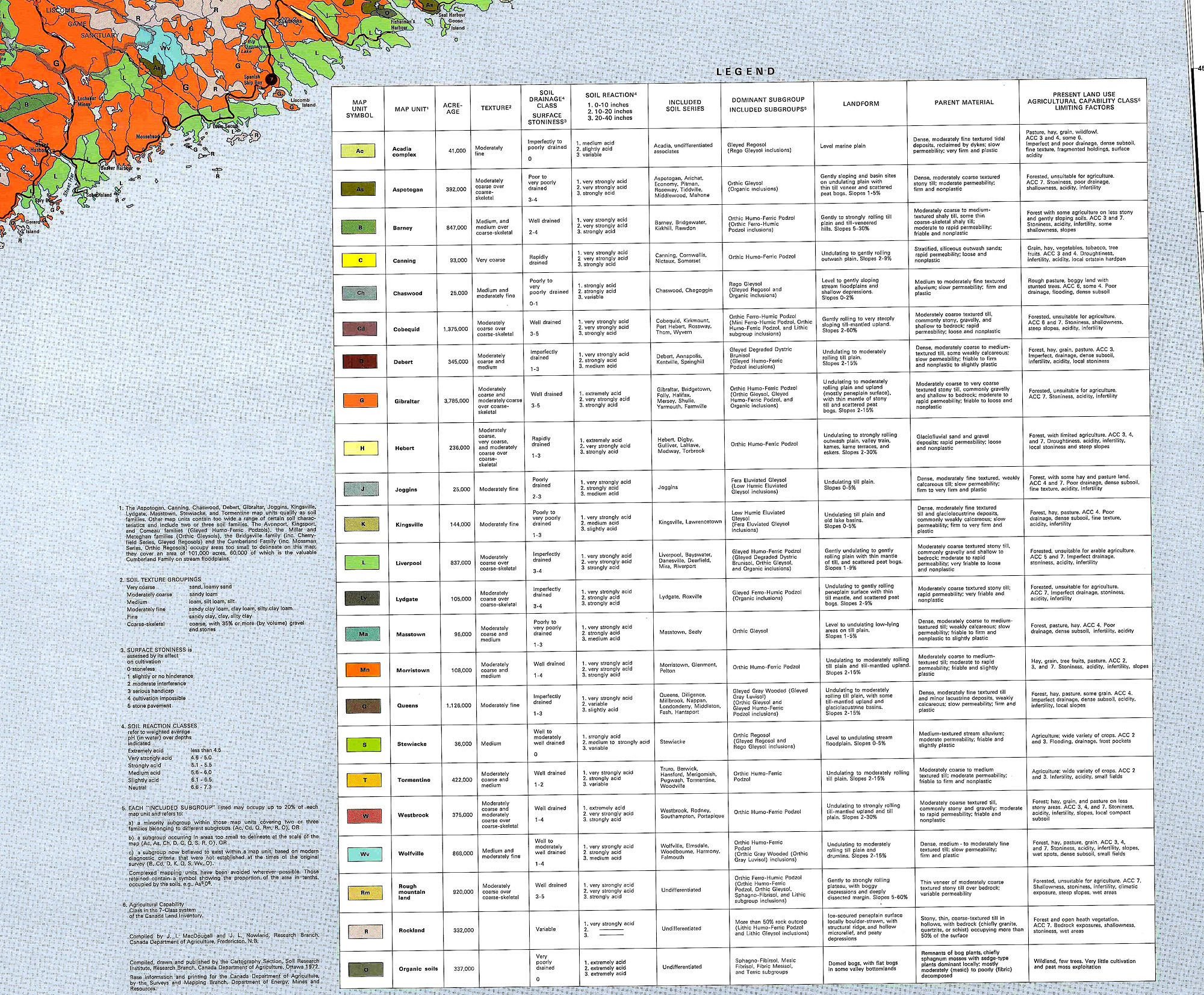
Soils of Nova Scotia
1972 Map Canada.ca/Agriculture and Agri-Food Canada/Agriculture and the environment/Soil and land/CanSIS/Publications/Soil Surveys/NovaScotia. 10510x7772px.
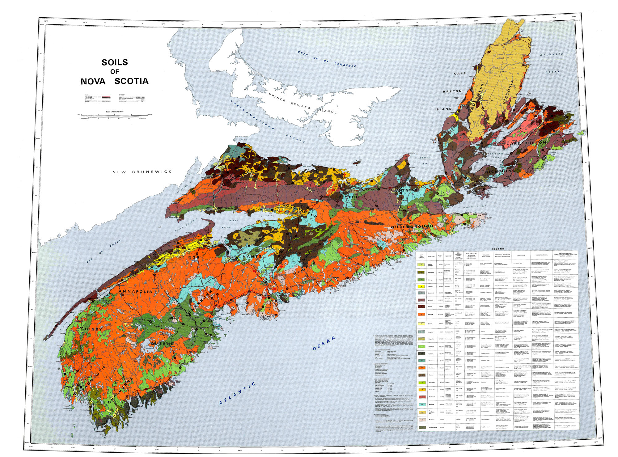 Click on map for larger (2000 px wide) version. Go to Ag-Canada site for 10510 px wide version. View Legend
Comment:
Over much of New England, as much as 75% the forested land which dominated the landscape when the settlers arrived was cleared, settled & farmed in the 16- 17- and 18-hundreds. With increasing urbanization and intensification of agriculture in the late 1800s to the early to mid 1900s, much of the agricultural was largely abandoned and reverted to forest, making eastern North America one of the few areas where there has been large scale net gain in forest cover in recent times [Thompson et al.,2013].
In contrast, in Nova Scotia, agriculture has been limited by poor or very rocky soils over much of the province and much of the province has remained forested throughout this time. Today forest cover is about 75%, down from ~85% in pre-settler days. 4.9% of the province is farmed, down from ~15% in the early 1900s. (View State of the Forest Report 2016). Most of the difference, about 500,000 ha, is now in Old Field forest succession; it was forested land cleared for agriculture and settlement, but now reverting to forest.
State of the Forest Report 2016
Lands
The vast majority of our province is forested. In fact, land use areas (Figure 1.1) show that over 75 per cent of Nova Scotia’s 5.5 million hectares (ha) are dominated by treed vegetation. These 4.2 million ha of forested lands also include areas that are returning to a young forested state after harvesting or for which there is no sign of permanent forest removal by agriculture, urbanization, or other anthropogenic (human induced) development. Approximately 7.8 per cent of the province is composed of naturally occurring non-treed ecosystems such as shrublands, beaches, and open woodlands primarily covered by small woody vegetation and herbaceous species. Coastal and inland wetlands account for about 2.9 per cent of the province. Agriculture covers about 4.9 per cent of the province. As per Fernow (1912), agricultural lands once occupied roughly 900 000 ha of the province. Today, only a third of that area remains farmed. The remaining 4.4 per cent of our province encompasses urban areas, the provincial transportation network, and anthropogenic non-forested lands. Urban areas (2.8%) are defined as any area used primarily as residential, industrial, and where related structures such as streets, sidewalks, parking lots, and housing developments prevail. The transportation network (1.1%) is composed of roads, rails, electric transmission corridors, and pipeline corridors. The anthropogenic non-269,5000forested land use category (0.5%) is composed of mines, landfills, quarries, and other features.
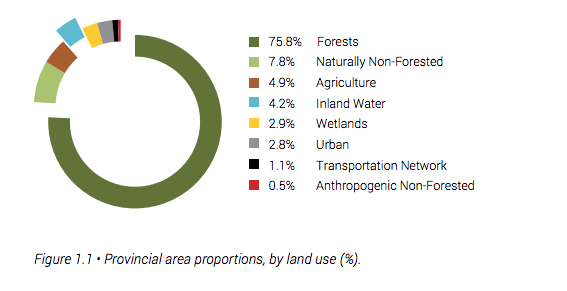
Comments. The sum of the percentages for Non-forested, Inland Water and wetlands is 14.9%. Thus the pre-Columbian forest percentage is estimated as 100-14.9=85.1%.
The acreage given in Fernow (2012) pages 17&18 for farmed land is 1,832736 acrea=741,682 ha, not the 900,000 ha cited above. It is stated above that “Today, only a third of that area remains farmed”, which based on 900,000 ha would be 300,000 ha. Above the percentage of land in Agriculture is given as 4.9%, which would be 0.049 x 5,500,000=269,500 ha, which is 36.3% of Fernow’s 741,682 ha.
Fernow Farm (Cleared) land – Current Agriculture Land= 741,682 ha-269,500 ha = 472,182 ha. So this is an estimate of the land that is currently re-foresting from land once cleared in NS. It is equivalent to 8.6% of the total area of NS.
Fernow’s cleared area, 741,682 ha is equivalent to 13.5% of the total area of NS. So the Percentage of forested land in the time of Fernow is estimated as 85.1%-13.5%=71.6% From that should subtracted a further X%to account for habitations, roads, other non-agricultural use of land (today it is 4.4% of total land area, so, e.g. if it were 3%, that would make the forested area 68.6% of the total land area
| In summary, the pre-Columbian forest cover was approx 85% of the total area (land + inland water & wetlands). The non-forested area was made up of naturally non-forested land, open water and wetlands. By the time of Fernow, forest cover was reduced to ~68%% of the area. Currently, forest cover is approximately 75.8% of the total area, agriculture 4.9%, and human-utilized land other than agriculture and forestry, 4.4% of the total land area. |
In contrast, much more of the land was cleared from forest in New England – as much as 75% of some states – but as in NS “over the last 150 yr, much of the land cleared for agriculture has reverted to forests” (literature reviewed in Richardson et al., 2014).