
From “Implementing Ecosystem-based Integrated Resource Management in Nova Scotia” by Bruce Stewart and Peter Neily, 2008. pp 71-77 in
Implementing Ecosystem-based Management Approaches in Canada’s Forests. A Science-Policy Dialogue Edited by Brenda McAfee and Christian Malouin Published by Natural Resources Canada Canadian Forest Service Science and Programs Branch Ottawa, p 75: “The Interim Old Forest Policy, 1999, established an objective to identify and protect the best remaining old forests and old-forest restoration opportunities on a minimum 8% of Crown land in each of the 39 ecodistricts (NSDNR 1999b). Most of this objective has now been met.” References: Nova Scotia Department of Natural Resources. 1999b. Nova Scotia’s old growth forests: interim old forest policy. www.gov.ns.ca/natr/forestry/planresch/oldgrowth/policy.htm [Accessed January 2008.] This site and document are no longer available on the web (12May2022).
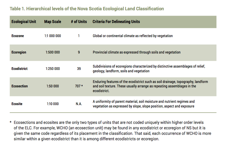
Ecodistricts
“Nova Scotia’s ELC uses a standardized methodology for defining and describing the geography of terrestrial landscape-based ecosystems. By nesting the ecosystems within a hierarchy (and by providing linkages among ecosystems in the different levels), the integrated system can be tailored to suit resource management objectives at the appropriate scale and level of detail. The ELC is comprised of five levels, each defined at a set spatial scale (See Table 1).” – Ecological Land Classication for Nova Scotia (2017 document) Also see NSDNRR webpage Ecological Land Classification
Old Forest Policy Map
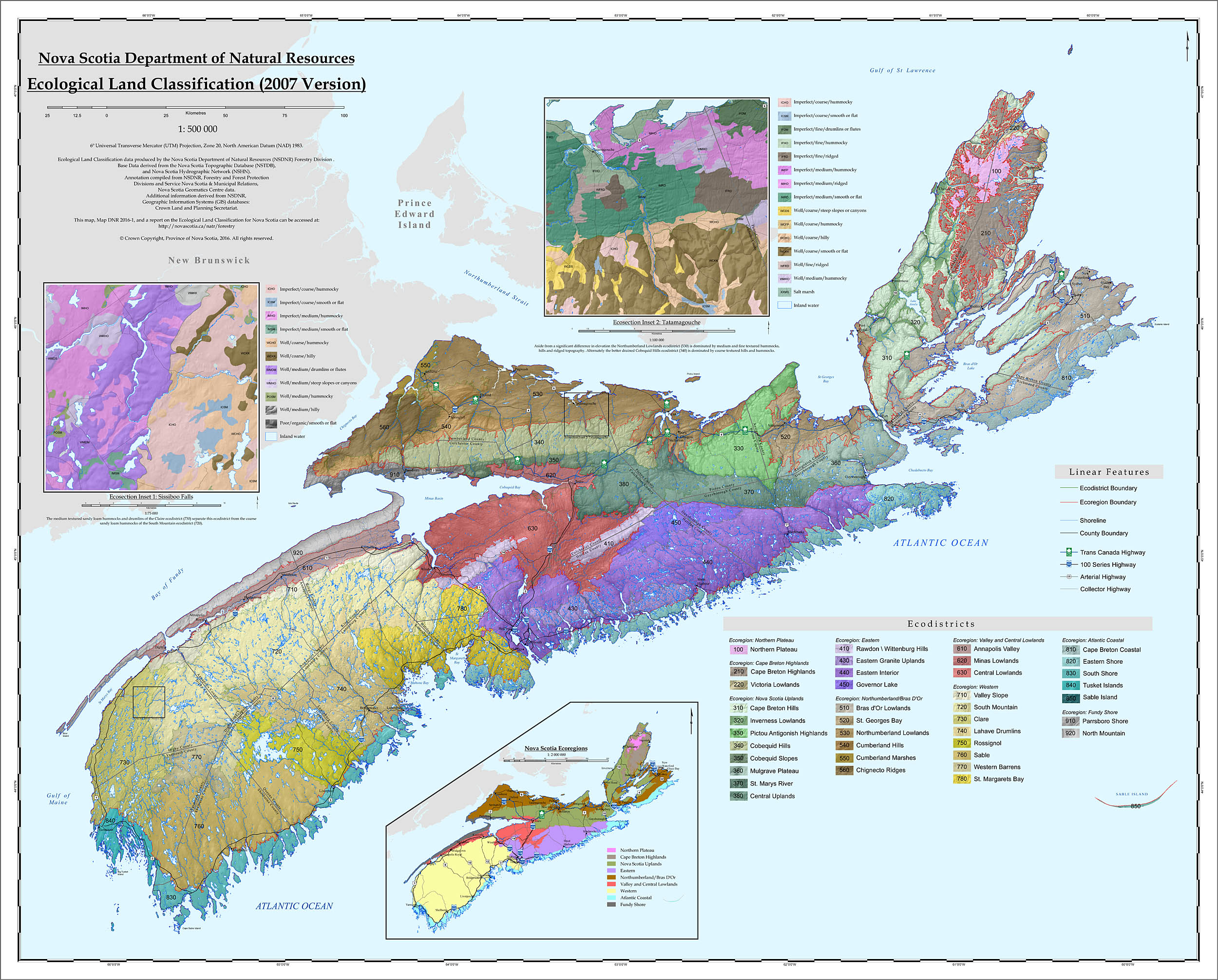 NSDNR Ecological Land Classification (2007) View Largest Version on DNR website |
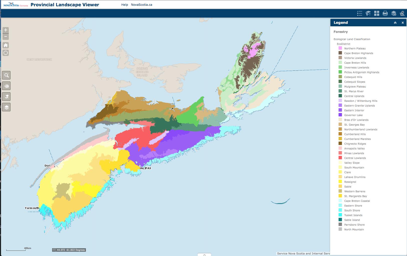 Ecodistricts layer on the Provincial Landscape Viewer |
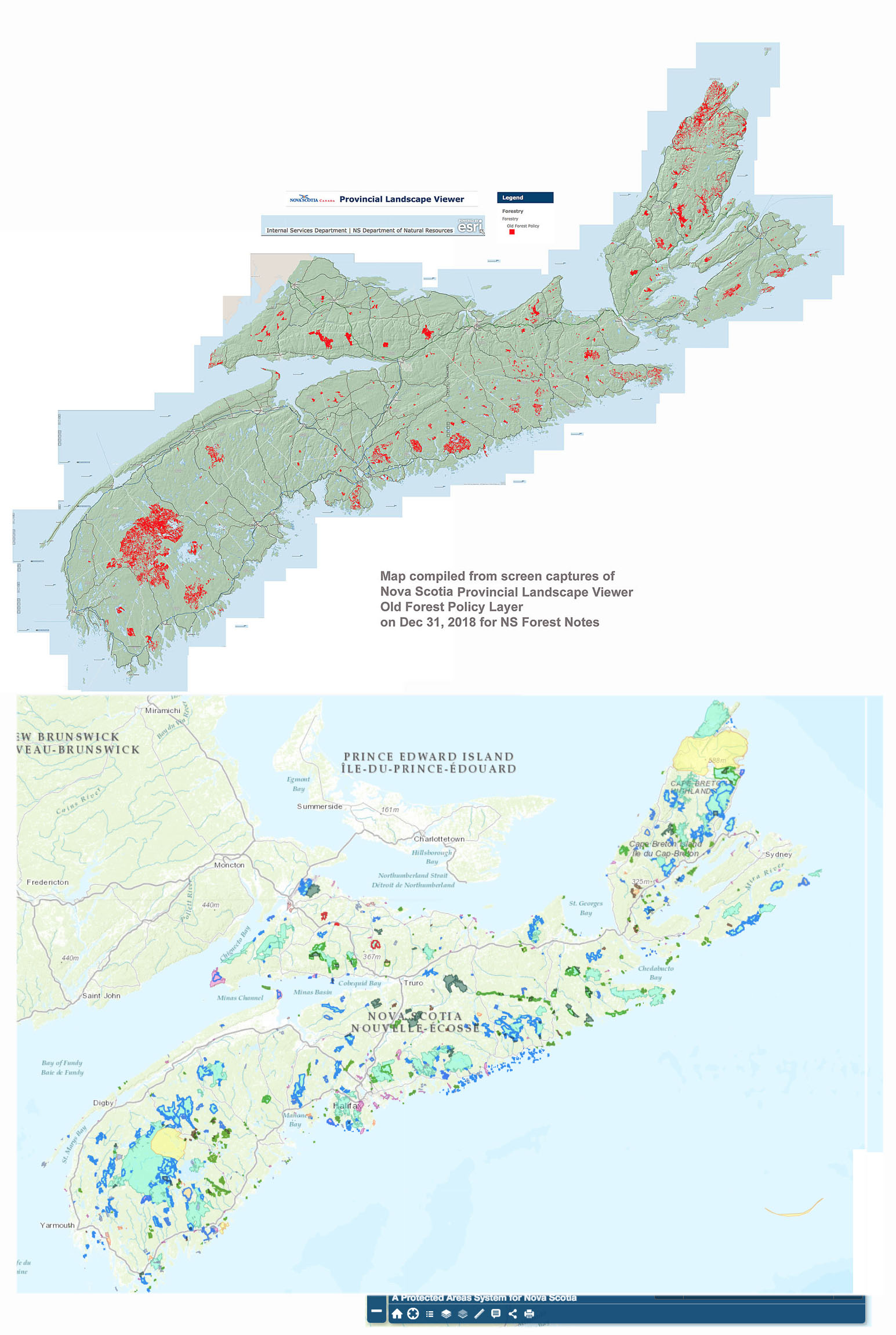
Old Forest Policy Map above and PPAs (Parks & Protected Areas) below.
PPA from Protected areas interactive map
Click on map for larger version.
Age of Forest Selected Under the Interim Old Forest Policy
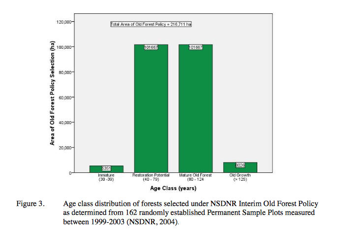
Age of Forest Selected Under the Interim Old Forest Policy
From Stewart & Neily 2008
Procedure for selecting stands
From Stewart & Neily 2008
Step 1:
All old growth (> 125 years old) within existing protected areas (including federal parks) is given the first priority to meet the policy targets.
The 1999-2003 provincial forest inventory (NSDNR, 2004) indicates that only 0.3 percent of the province is over 105 years of age. Therefore it was assumed that no ecodistrict had sufficient old growth in protected areas to meet the policy target, and a search of protected lands for old growth was not necessary to verify this.
Step 2:
All old growth (> 125 years) on Crown land outside of protected areas (IRM – C1, C2) is the next priority for meeting the policy targets.
IRM teams assessed all known old growth and identified it under the policy. A moratorium was placed on harvesting any stands found to be over 125 years of age. During operations planning any old stands encountered that were potentially old growth were assessed using the old forest scoresheet in the policy to determine their status. As with step 1, it was assumed that no ecodistrict had sufficient old growth to meet the policy targets, and a full inventory of all lands was not required to verify this.
Step 3
Within protected areas (C3) all “ climax” forest stands greater than 40 years of age are considered old forest restoration opportunities, and are given the next priority to meet the policy targets.
A query of the Geographic Information System (GIS) forest inventory2 was carried out to identify all qualifying stands within protected areas. These were mapped and the data was summarized by ecodistrict to identify gaps regarding the area and climax forest representation targets of the policy.
Step 4
Where gaps existed, the best old forest restoration opportunities on Crown land outside of protected areas (C1, C2) are identified and set aside following the criteria and objectives of the policy.
From a practical stand point, most of the implementation effort occurred at this step. A GIS based old forest prediction tool was developed to help identify promising candidates. Training sessions were conducted in all regions. Professional knowledge, and the experience of the regional IRM teams with their areas was then relied upon to find the best candidates. Planning was assisted with aerial photography and site visits. A number of stands were field assessed using the old forest scoring procedures. In making final selections, teams employed professional judgement to balance the objectives for old stand conditions, large patch size, and ecological representation, as well as trying to achieve other multiple values where opportunities presented.
Step 5
Select additional area above the policy targets where regionally important features exist.
IRM teams identified a significant amount of area beyond the eight percent policy target in many of the ecodistricts. In some cases this was necessary to meet objectives for climax forest representation, while in others it was a recognition of important stand qualities, and opportunities to improve patch sizes.