
Also view:
- CURRENT ISSUES/AP068499 Beals Meadow
- On logging of Nova Scotia Crown land parcel AP068499 Beals Meadow : 3. The Depleted Soils 19Jun2022
NSFN Post, June 19, 2022- CURRENT ISSUES/AP068499 Beals Meadow/Nutrient Budgeting for AP068499 Beals Meadow
———-
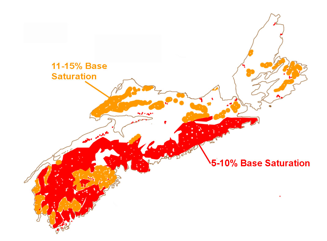
Area of low base saturation soils in NS. Drawing after Keys et al. (2016)Fig 3
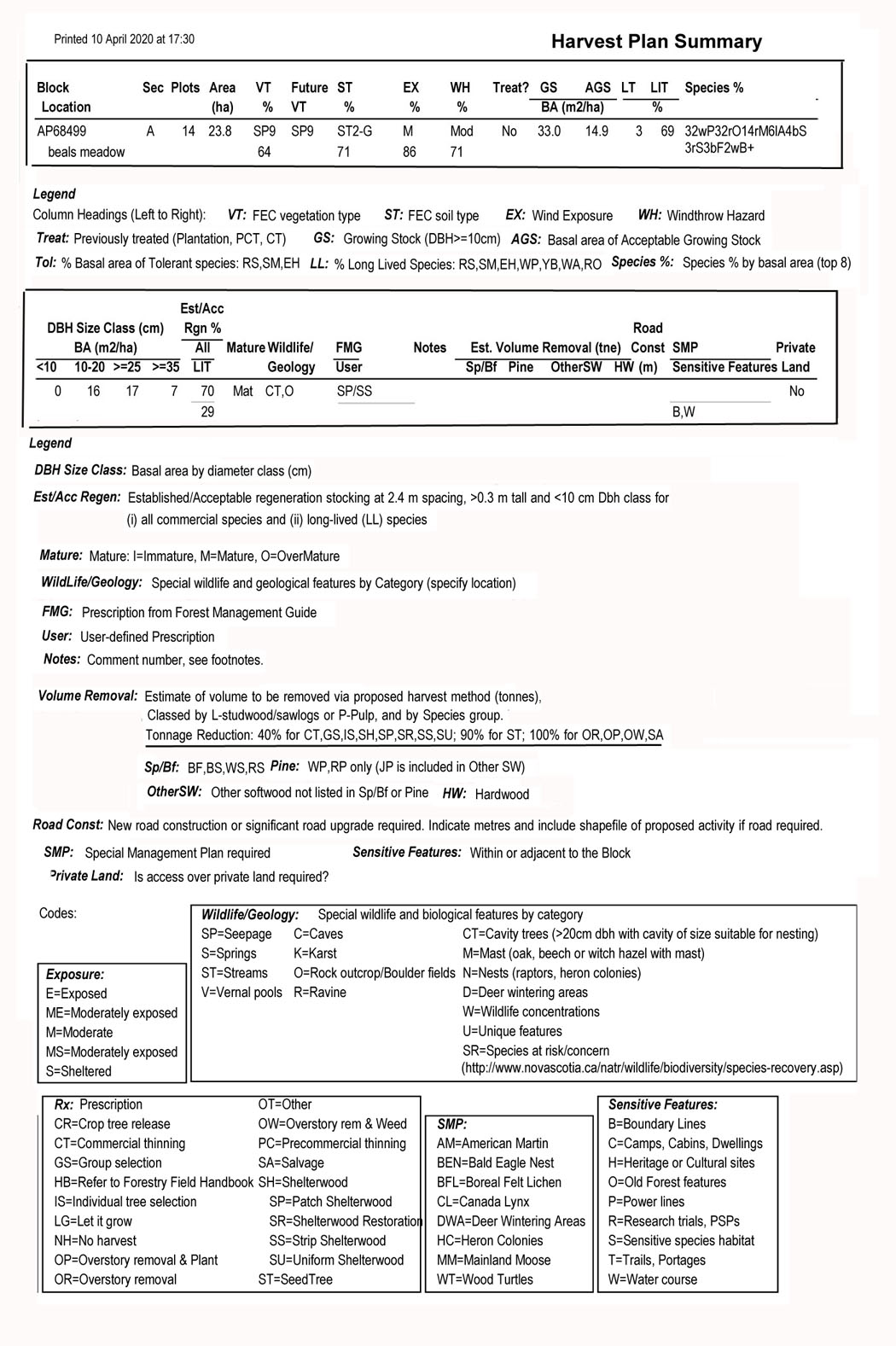
AP068499 Beals Meadow is situated within the broader area of low base saturation soils illustrated in the sketch at right, which is based on Keys et al., 2016. However, that’s a pretty coarse scale map.
A geology (bedrock) map for the area places AP068499 Beals Meadow on Middle-Late Devonian biotite monzogranite. It’s nutrient poor, slowly weathering bedrock.
The Surfical Geology Map places most of AP068499 Beals Meadow in an area of “Stony Till Plain (Ground Moraine). Stony, sandy matrix material derived from local bedrock sources…stoniness, rapid drainage, erodability; poor buffering capacity for acid rain.”
The Soils of NS Map places AP068499 Beals Meadow within the Gibraltar Series Soil Unit for which Present and Use Capability is “Forested, unsuitable for agriculture…Stoniness, acidity, infertility.”
The more recent Forest Ecosystem Classification Soil Type/Pre-Treatment Assessment Reference Viewer places most of AP068499 Beals Meadow I FEC Soil Type Group 1. There is a wee bit of Soil Type 3G, and an even smaller bit of Soil Type 4 [14,G]
From Forest Ecosystem Classification for Nova Scotia Part II: Soil Types (2010) for ST1:
Description
ST1 is associated with dry, sandy or dry, very gravelly to very cobbly coarse-loamy soils. In both cases, the ability to retain moisture and nutrients is reduced due to high sand and/or coarse fragment content. Gravel plus cobble content in surface horizons is often > 50%, but may also be absent in sandy glacio uvial deposits. Stone and boulder content also varies by parent material type. Site drainage is usually well or rapid, but can be moderately well in lower or level slope positions. ST1 profies usually contain a thick, well developed Ae horizon and may also contain partially or fully cemented B horizons.
Distribution
ST1 can be found scattered throughout the province, but is most common in the Western (700) ecoregion where it is associated with coarse, granitic glacial till; in the Annapolis Valley (610)
and Minas Lowlands (620) ecodistricts where it is associated with sandy outwash (glacio uvial) deposits; and in the Northumberland / Bras d’Or ecoregion (mainly Cumberland County) where it is associated with sandstone enriched glacial till.Ecological Features
ST1 is generally very poor to poor in fertility and prone to drought. It is usually associated with spruce pine (SP) or open woodland (OW) vegetation types, but may support selected vegetation types from other forest groups (especially where deep-rooting trees can access additional moisture). Associated humus forms are mainly Hemimor and Humimor, with Resimor also common (especially where ericaceous species dominate the shrub layer).
So it appears that the soil and bedrock of most of AP068499 Beals Meadow is the really nutrient poor, acidic ST1
HOWEVER, the PTA for the site under Soil Type says that it is 71% ST 2G; From the description for ST2 (ST2G is a “phase” of ST2):
Description
ST2 is mainly associated with fresh, coarse-loamy soils dominated by sandy loam texture. Coarse fragment content is generally low to moderate in surface horizons, but levels can be higher in soils derived from granite, quartzite, or sandstone tills. Site drainage is usually well, but ranges between rapid and moderately well depending on slope position, slope percent, and subsoil permeability. ST2 pro les usually contain a well developed Ae horizon, but Ahe horizons can also be found, particularly in loamy soils (ST2-L). Cemented B horizons are also possible.Distribution
ST2 is the most common upland forest soil type in Nova Scotia and is found throughout the province, particularly where softwoods and mixedwoods are the dominant cover. ST2-G is mainly found in the Western (700), Eastern (400), and Atlantic Coastal (800) ecoregions; while ST2-L is common in the Nova Scotia Uplands (300) and Fundy Shore (900) ecoregions, and on drumlin ecosections throughout the province.Ecological Features
ST2 is generally poor to medium in fertility, but is sometimes richer (especially ST2-L). Moisture may be somewhat limiting during the growing season (especially in coarser soils), but usually not severely so. ST2 is associated with all forest groups except wet coniferous (WC), wet deciduous (WD) and oodplain (FP). Associated humus forms range from acidic mors (mainly Hemimor and Humimor) on softwood dominated sites, to medium fertility moders (mainly Mormoder) under mixedwood and hardwood cover. Resimors are also possible, especially in coastal (CO) and Highland (HL) softwood stands.
Some Questions I asked of NRR: (March 2022)
‘Wonder if you can clarify for me, re the assignment of soil type for the Beal’s meadow PTA, ST2-G, 71%
- Is that based on actual observation, i.e. digging soil pits and keying out the soil type? How many soil pits?
- Were any soil samples taken and analyzed for nutrients?
- Does 71% mean 71% of the area was this soil type? How is that no. derived?
I note the soil types cited for VT SP9 are ST2, ST2-G, ST5
I note from the Pre-Treatment Assessment Reference Viewer that most of AP068499 Beals Meadow I FEC Soil Type Group 1. There is a wee bit of Soil Type 3G, and an even smaller bit of Soil Type 4 [14,G];
- why the disparity between these mapped soil types and soil type cites in the PTA for AP068499 Beals Meadow?
Response: (italic inserted)
...to clarify a couple of points…
As noted under the “About” tab on the PLV soil type map:
The soil type map was derived from four province-wide data sources:
– the 2011 digital (stitched) soil series map (1:75,000 scale) from Agriculture and Agri-Foods Canada,
– the digital Wet Areas Map (WAM) layer,
– the digital elevation map (DEM) layer, and
– NSDNR forest cover and land-use datasets.Although rules used to separate soil type units were calibrated using several hundred FEC plot point data, users are reminded that this map is based on other maps and datasets with their own scales and inherent levels of accuracy. In addition, most soils grade into other soils, so hard boundaries are rarely accurate – especially with respect to texture changes.
Therefore, this map should not be considered definitive, only an approximation based on available data. As such, no claims are made by NSDNR as to the accuracy of this map. Also, with respect to PTA assessment, use of this map does not replace the need for on-site field assessment.
Looking at the PLV, the site is mapped as mainly 2|1 [G] which means the soil type is predicted to be mainly ST2 or ST1 with G-phase also possible. This is the designation given to all well drained Gibraltar soils. Therefore, the fact that 71% of the site is classed as ST2-G is in keeping with the predicted map unit. It is also not surprising there is some deviation from that, that’s what the ground check is for.
Regarding soil sampling, nowhere in the PTA protocol are samples taken for analysis. The NBM does not take into account the current balance in a nutrient “bank account”, only the estimated inputs and outputs in relation to the soil type and vegetation type combination at a given site. We know base cation nutrient levels are lower than desired, which is why we build in a recovery factor in the NBM runs. If we did not do this, calculated SusMAI values would be higher.
——————————————–
For reference: The soil sampling protocol given in Pre-Treatment Assessment (PTA) Methods and Tools
by Tim McGrath. 2017. NSNDR. (Cited as a “Draft”),
Determine the ecosystem characteristics represented by the sampling point including vegetation type and soil type. Soil augers or soil pits do not need to be dug at every point. A soil auger sample or soil pit must be dug to verify soil type wherever stand conditions would indicate a change (e.g. soil moisture, rockiness etc). Soil type must be recorded at every sample point to verify whether it has changed or not and whether the soils have been examined using an auger or by digging a pit.
Also view: Forest Soil Types of Nova Scotia: Identification, Description, and Interpretation
By Kevin Keys. 2007 Nova Scotia Department of Natural Resources Manual FOR 2007-2
For the “About” tab on the PLV soil type map, go to the PTA Reference Viewer, click on the “I” icon at top right to bring up the info page.
So an important point I learned from this Q&A that I had not understood before this:
“The NBM does not take into account the current balance in a nutrient “bank account”, only the estimated inputs and outputs in relation to the soil type and vegetation type combination at a given site.” That I had not understood. The Soil Type info (however derived) is NOT used to estimate the current levels of nutrients at a site.
As I understand it, the soil type info is used together with the FEC vegetation type (VT) and ecosite combinations to estimate forest mensuration values that go into the Forest Nutrient Budget Model; and, roughly speaking, the better (more fertile) the soil type, the higher the estimated value of both the Merchantable MAI and the Sustainable MAI. So the model is sensitive, it could be said, to correct identification of soil type.
For further reference, see
– A Woodland Owner’s Guide to Forest Ecosystem Classification in Nova Scotia
– Ecological land classification for Nova Scotia.
Neily et al., 2017. Nova Scotia Department of Natural Resources, Report FOR 2017-13.
– Forest ecosystem classification for Nova Scotia (2010)
Neily et al., 2013.