
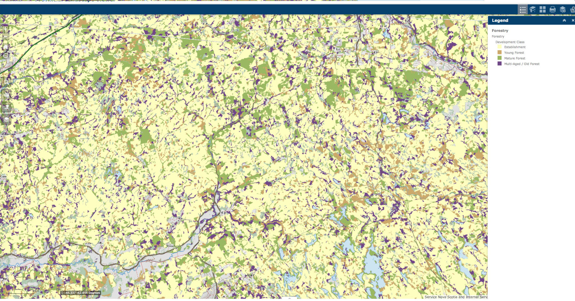
Prevalence of early forest development stages in central Nova Scotia can be attributed to “High-grading at the Landscape Level” over the last 60 years. Map from the Provincial Landscape Viewer Click on image for a larger version.
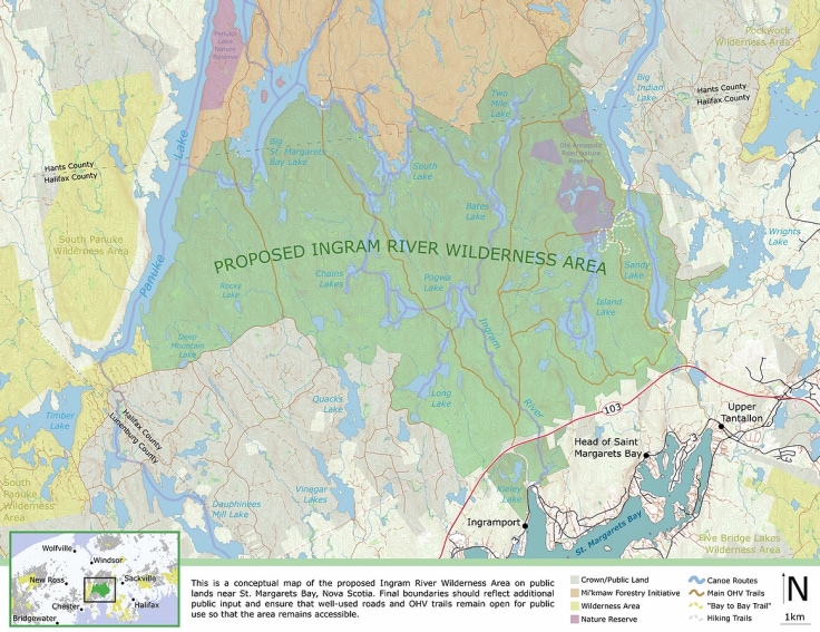
Examples from the two most recent Harvest Plan Notifications, one in Queens Co. in SW Nova Scotia and one in the area of the proposed Ingram River Wilderness Area (Halifax Co.) illustrate how the practice of “log the best and leave the rest” (high-grading) continues to operate at a landscape scale on Nova Scotia’s Crown lands, the Lahey Recommendations (2018) and those of the Natural Resources Strategy (2010) notwithstanding.
Supposedly the crime of previous generations of foresters was to “log the best and leave the rest”, so-called “high-grading”.
From the Glossary of Key Terms for the NS Woodlot Home Study Module 2:
high grading – the removal of only the best trees from a stand, often resulting in a poor quality remaining stand and poor seed for the next generation
According to Forestry Professor and advisor to L&F Graham Forbes, we long ago moved away from that practice:
By the 1950s, Crown land was still managed primarily for timber production but there was a move away from exploitative forestry, with a tendency to take the best trees (e.g. ‘high-grading’), towards management and silvicultural practices that could produce a regular supply of timber. This era of “sustained yield”, through the regulation of harvest rates and, by the 1970s, implementation of tree planting and stand tending maintained a suite of mills across Nova Scotia…The term ‘habitat’ had relevance primarily in terms of game species populations… By the 1980’s society demanded much more from the forests than timber and game species… the provision of aesthetic viewscapes, spiritual opportunities, and ecological services such as clean air and water…also the maintenance of all forms of life, from fungus to frogs to falcons. We must now consider the value of rotting wood as much as live wood…This [progressive] evolution in forest management is not unique to Nova Scotia; similar trajectories occurred across North America, Australia, and Europe.
So we have moved away from exploitative forestry? How come early successional forests dominate most of the landscape in central and eastern Nova Scotia? And what do you call the furious rush to take out the still relatively plentiful old forest stands in SW Nova Scotia, illustrated again and again in Crown land Harvest Notifications and subsequent harvests?
From the Dec 30, 2020 Notification, for Queens Co., SW Nova Scotia:
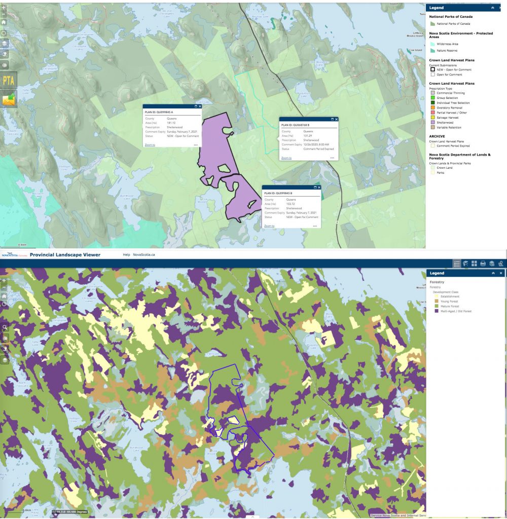
Above: From Harvest Plan Map Viewer. Below: Proposed harvest areas are layered on a PLV Forest Development Stage Map. The green patches are mature forest, purple patches are multi-aged/Old Forest. (Clearly this was once moose country, if not now re: Moosehorn Lake, Little Moosehorn Lake, Bull Moose Lake, Cow Moose Lake, Bull Moose Brook.) Click on image for larger version
No surprise I guess, the mills are targeting the purple patches which is where the Big Trees are located; lumber has replaced chips as the most most profitable forest product and a highly profitable product in this time of Covid Home Renovations.
But compare this area of SW Nova Scotia where there has been relatively light (for NS) logging in the last 60 + years with Central Nova Scotia which has probably the most intensively harvested forests in Canada, and you can see the direction we are headed (only faster this time around).
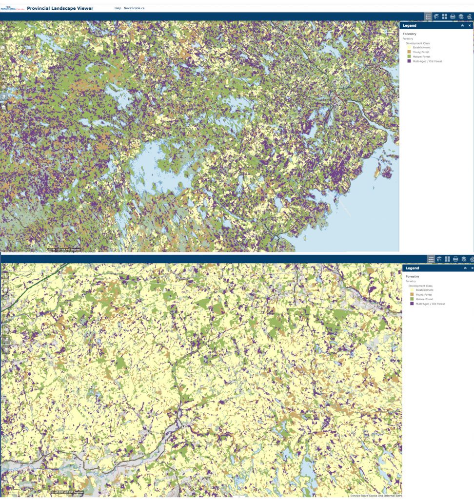
PLV Forest Development Stage Maps for area in Queens Co. (top) and just east of Truro (bottom). The purple patches are multi-aged/Old Forest. Click on image for larger version
I call it “high-grading at the landscape level“.
Supposedly, the Lahey Recommendations were going to stop all of this, but coming up to 3 years since Lahey handed in his report and 11 years since the first commitment to rein in logging Crown land, there’s still only talk of that happening.
That was the last Harvest Plan Notification of 2020. The first one of 2021 didn’t break any moulds; from S.L. on Stop Spraying & Clear-Cutting Mi’kma’ki, Jan 7, 2021:
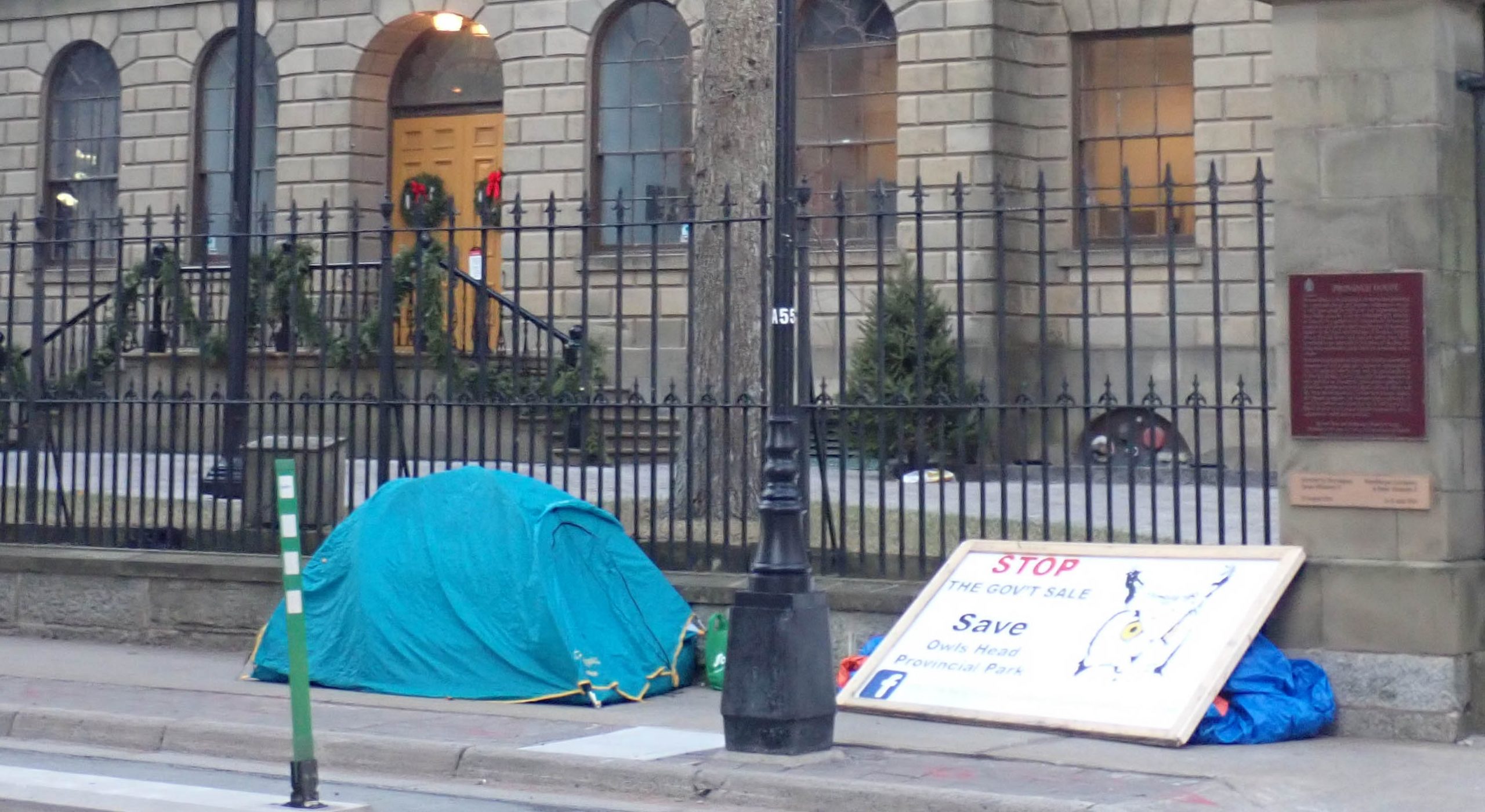
Halifax County on the chopping block:
Comments: These proposed cuts in Halifax County are within the boundaries of our proposed Ingram River Wilderness Area. Five protected species have been identified in the surrounding area. It’s also an area that’s crucial for cross-province terrestrial migration and is currently under investigation for protection. The five protected species that have have been identified are olive-sided flycatcher, chimney swift, common nighthawk, Canada warbler, and another one that cannot be make public at this time.
Please leave your comments on the Harvest Plans Viewer Map to help keep this area and the protected species safe against habitat removal. We know it will take some time to comment on all these cuts, but the species and forest will love you for it. Thank you in advance.
DNR ID: HX068739; HX068739; HX068739; HX068739; HX068739; HX068739; HX068739; HX068739; HX099876 B HX099876 D; HX099876 N; HX099876 H; HX099876 E; HX099876 X; HX099876 S; HX099876 T; HX099880
I checked it out, the area is closer to Halifax and not as heavily purple as the Crown lands in Queens Co. above, except in a nearby existing Protected Wilderness Area. Again I looked at the relationship of proposed harvest areas to forest development stage.
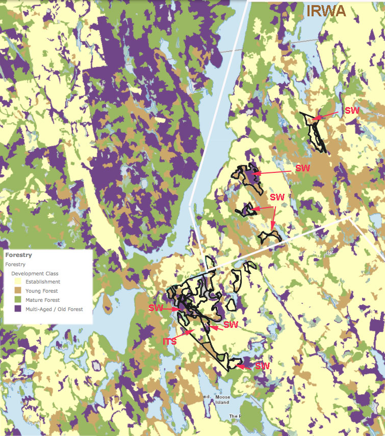
Harvest polygons from the HPMV layered over Forest Development Class from the Provincial Landscape Viewer. Prescriptions are SW-Shelterwood, ITS-Individual Tree Selection; the rest are Commercial Thinning. Area enclosed by the white borders lies within the proposed Ingram River Wilderness Area*. The areas to the west that are mostly Mature Forest/Multi-aged Old Forest (green and purple patches) are in the South Panuke Protected Wilderness Area and illustrate a more natural state of forests in this region; but without landscape level planning for conservation of old forest biodiversity across the landscape, biodiversity and ecological integrity of the Protected Wilderness Area will inevitably decline. * So some of these harvests are within the proposed Wilderness Area, some are not. L&F has apparently committed to not harvesting over most of the Ingram River Wilderness Area, but their version of it doesn’t overlap entirely with the proponents’ version – the area above that is within the proposed Wilderness Area is one area where they do not overlap.
Sure enough, they are picking off some of the few remaining purple patches. In one polygon which is mostly early successional forest, the prescription is Individual Tree Selection (ITS) – it seems they will pick out individual trees from the few patches of old forest that are left (see “ITS” and arrow in the figure above). Is this what “individual tree selection” is all about – high-grading? Are they taking the wildlife clumps retained in the previous harvests? Bev Wigney thinks so. In a letter to Forestry Maps on Oct 15, 2020, she wrote
…What’s with all of these little cuts between already devastated forests that are now gone, like the parcels up for approval around Paradise Lake? Now you seem to be posting tons of these small stands – on one of the last Forestry Maps listings, about 1/3 of all the parcels were just small parcels — many just 2 ha. What are these? Why weren’t they cut down earlier? Were they left standing as wildlife shelter areas so that you COULD go ahead and cut down everything around them?
I went out and looked at some of them. They aren’t hard to find as they are the LAST and ONLY patches of forest left standing in between the *already devastated* parcels where there is NOTHING anymore. Where do you expect the wildlife to “move to” next when you cut down the very last parcels between the already clearcut areas?

From R. Seymour, Section 2.4 Ecologically Based Multi-Aged Silviculture in the Acadian Forest, in Research Addendum to A Natural Balance: Working Toward Nova Scotia’s Natural Resources Strategy 2010
It is interesting that “Shelterwood” (most can be expected to be the first stage of 2-stage clearcuts, with the 2nd stage, Overstory Removal after 3-5 years) and Commercial Thinning seem to be the harvest flavours of the day for Crown lands, at least in the last two announcements. What’s driving the commercial thinning? Silviculture funding? A market for firewood? What happened to Robert Seymour’s Irregular Shelterwood cuts which the Lahey Report repeatedly recommends? I asked L&F and was told that such cuts are still experimental. Ouch. The Natural Resources Strategy was promoting them back in 2010, and they are still experimental???!!!!
Speaking of which, what has happened to the Old Forest Policy Project? It is the one Project that would – according to the skimpy description of it – lay out what we need to keep in the way of old forest to conserve Old Forest Biodiversity. It would, presumably or probably or hopefully, indicate how much and which of the purple and green blotches should be retained in working forest, i.e. it would provide the landscape level planning for biodiversity conservation that is lacking currently. Last August, the timeline for the Old Forest Policy Project cited “Stakeholder engagement in 2020; Revisions to Old Forest Policy to be finalized by the end of 2020” but now no schedule is given (view current information for the project on the Ecological Forestry page).
Fortunately for the Big Forestry folks but not for the rest of us, the Lahey Recommendations had little to say about carbon storage (carbon sequestration) in our forests, and L&F has kept its carbon modeller well out of site. So we are not, apparently, concerned about losses of carbon storage when we harvest these older forests that hold the most carbon.

Reading the Lahey Report, hot off the press, at Province House on Aug 21, 2018
What I am most worried about in the Lahey process at this point, however, is that when L&F finally comes out with its plan to implement the Lahey’s Recommendations, the HPF (High Production Forestry) component will be little altered from the proposals they floated in the Discussion Paper released last February. (View Post May 11, 2020 for some major concerns, notably about the area assigned to HPF relative to the Ecological Matrix)
Basically, that paper proposes that the most productive, high volume, old forest stands be assigned to the HPF component. Then they can be clearcut followed by spraying/even-aged management or by establishment of plantations and in the next rotation, trees are grown to only 10-12″ dbh (or less) – that’ s a product the sawmills are prepared or are preparing to deal with in the form of “mass timber” once the bigger trees and the easy profits are no more.
It would be the final stage in the high-grading of our Crown land working forests – this one courtesy of the Lahey Process/finessed by L&F.
Does it matter?
Concerns of foresters about the impact of high grading relate mainly to the impacts on longer term yield and profitability:
The negative financial impacts of high grading are clear. In most cases, high grading results in a greater harvest volume and value from the first cutting, compared to forests managed using silvicultural principles. However, neither the harvest volume or timber quality is sustained over the long run by high grading. After the first high grade harvest, the woods will provide:
❶ Less total volume because of slow growing trees and irregular spacing between them.
❷ Less volume from large trees of the more valuable size classes (16”+ veneer).
❸ More volume from poor quality trees and low value species (i.e., red maple, hemlock)
❹ Less frequent opportunities to return for another harvest.The net effect is less money to landowners over time. In short, it means that if you want predictable levels of periodic income and maximum long-term financial benefits from your woods, do not high grade – from High Grade Harvesting, Understand the impacts, know your options by Paul Catanzaro & Anthony D’Amato, 2006, UMass Extension
Such effects are largely local; they operate at the stand level. High-grading at the landscape level, as in Nova Scotia, is a step up from high-grading at the stand level. In addition to the yield/long term profitability issues, it introduces serious ecological impacts, most notably the loss of old forest biodiversity, and the loss of carbon sequestration.
The Lahey Recommendations, if they had unfolded as envisaged would have at least begun to address the biodiversity issue; and if, as Lahey & Co. predicted, there would be a reduction of Crown land wood supply of 10 to 20 per cent, it would at least leave more carbon in the forests. But somehow or another L&F just decided that there would be minimal changes in forestry practices on Crown lands until they had studied it all for a few years (except that a few restrictions applied while the Independent Review was underway were removed) and further that there would be no reduction in wood supply.
Sunrise in Moose Country Jan 11, 2021
Now, coming on 3 years after completion of the Lahey Report and 11 years after the Natural Resources Strategy recommendations for forestry, and in spite of lawsuits, widespread public protest and national and international concerns over biodiversity loss and climate warming, L&F/the NS Government remain mute on these topics.
And high-grading at the landscape level continues, unabated, while L&F figures out how to respond to the Lahey Recommendations.
LINKS
More on the Ingram River Wilderness Area
Area of the proposed Ingram River Wilderness Area
Protect Ingram River Wilderness Area
Campaign website
News brief: Wilderness designation of unique ecological area near Halifax reaches critical stage
Robert Devet in the Nova Scotian Advocate
Backroad Deal Part 1: The decision to build the ingram access road, which slashes through what conservationists say is an old growth forest, was made in part to reduce transportation costs for Ccotian materials, and in part to increase access to Crown forests for logging companies
Linda Pannozzo in the Halifax Examiner, May 18, 2020, 2020
Backroad deal part 2: Nova Xcotia’s policies to conserve the province’s endangered forests might be doing more harm than good
Linda Pannozzo in the Halifax Examiner, June 1, 2020
Conservationist pushes to save one of Nova Scotia’s last patches of old-growth forest
CBC News · Posted: Jun 26, 2019 “‘We’ve got about 0.6 per cent of our remaining old-growth forest,’ says Mike Lancaster”
Proposed Harvests within Boundaries of Proposed Ingram River Wilderness Area
Post on St. Margaret’s Bay Stewardship Association, Jan 2019
Healthy Forest Coalition thanks Minister Rankin for first steps towards protection of the Ingram River Wilderness Area 14Jan2019
Post on NSFN Jan 14, 2019
Nova Scotian Old Growth on the chopping block
Zack Metcalfe Jan 1,2019
Paddling paradise: Big St. Margaret’s Bay Lake
Published by Tobeaction, Nov 20, 2020
Freedom of Information Document
Nova Scotia July 2, 2020, in response to a request “Correspondence between DLF/TIR and private owners affected by the Twinning project, specifically by a named business [Scotian Materials] and a named consortium [WestFor], from January 2018 onward.” 95 pages. Includes TIR and DLF Messaging (p19)
and an 18 page document on Guidance for Implementing the At-Risk Lichens Special Management Practices
On logging in SW Nova Scotia
Why we should worry about the few remaining mainland moose, now more than ever
Robert Devet in the Nova Scotian Advocate. There are many related recent news items under In the News, also Social Media Posts
“So many clearcuts” in SW Nova Scotia (continued) 20Nov2019
Post on NSFN Nov 20, 2019
Biodiverse Southwest Nova Scotia at Risk
Post on NSFN Oct 29, 2018.
Show us the science behind clearcuts on Crown land close to the pending Shingle Lake Nature Reserve, Nova Scotia
Post on NSFN August 9, 2017
Why is the low base saturation/soil acidification/nutrient depletion/extreme surface water acidity in SW Nova Scotia still ignored in Crown land harvest decisions?
Post on NSFN February 3, 2019