Also view these subpages:
Land Base/Historic Afforestation
Land Base/Forest Land Capability
On this page:
1. How much Crown land is still available for protection?
2.How much of Nova Scotia was forested in pre-settler times?
3. How much land was cleared and then later reverted back to forest?
4. How much Old Growth do we have in NS?
5. How much Old Forest do we have in NS?
6. How much Land is suitable for Agriculture
1. How much Crown land is still available for protection?
Some data and some calculations pertaining to increasing protected areas in NS to 30% of the landbase (from 14% existing or quasi-committed-to currently), re federal commitment to 30% protection.
One complication, it’s not always clear when figures for land area include inland waters and when they do not, however that’s a relatively small component and won’t affect the general magnitude of these estimates much.
From State of the Forest Report 2016 Asterisked values are my estimates.
| Component | Area or % of total land base |
| Total land base | 5,525014 ha |
| Private | 59% or ~*62.0% with inland waters |
| Provnce | 33.6% or ~*35.1% with inland waters |
| Federal | 2.8% or ~*2.9% with inland waters |
| Inland water | 4.2% |
From HPF Discussion Paper
| Component | Area in hectares |
| Gross Crown Landbase (Forested and Non-Forested) | 1,854,000 |
| Anthropogenic Non-Vegetated | 14000 |
| Converted (Anthropogenic Vegetated) | 2000 |
| Converted (Anthropogenic Vegetated) | 2000 |
| Triad Total Landbase (TLB) | 1,824,000 |
| Current, Committed Conservation (Provincial) | 630,000 |
| Ecological Matrix | 862000 |
| HPF | 333,000 |
If we assume that 14% of the NS landbase is currently protected or committed to be protected, that leaves 16% needed – 0.16 x 5,525014 ha = 884,002 ha to reach 30% protected.
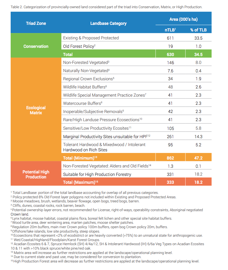
If that additional 16% is to come out of Crown lands, it would have to come from lands assigned above to the Ecological Matrix (which includes non-forest and non-working forest lands) and the HPF (High Production Forestry) components, which total 1,195000 ha.
884002 ha/1,195,000 ha x 100= 74.0%. So 74% of Crown lands not now protected would be have to protected to reach 30% protected area in total, leaving in principle 26% to forestry at best or 310,998 ha.
What is the area of “working forest” now? All of the lands assigned to the HPF component of the Triad in the table below above (331, 000 ha) are working forest. For the Ecological Matrix, the working forest, based on the figures below includes Marginal Productivity Sites unsuitable for HPF (261,000 ha) + Tolerant Hardwood & Mixedwood/intolerant Hardwood on Rich Sites (95,000 ha) = 356000 ha. So the total working forest is estimated as 331,000 ha + 356,000 ha = 687000 ha
From HPF Discussion Paper
The need to include a large component of existing old forest in the new protected areas To protect old forest biodiversity. currently greatly diminished by extensive clearcutting AND to maintain a high level of carbon storage in our forests, the new protected areas would have to include a large component of existing old forest (i.e. late mature and multi-aged old forest layers in the Provincial landscape Viewer):
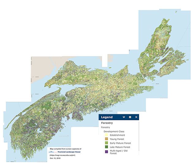
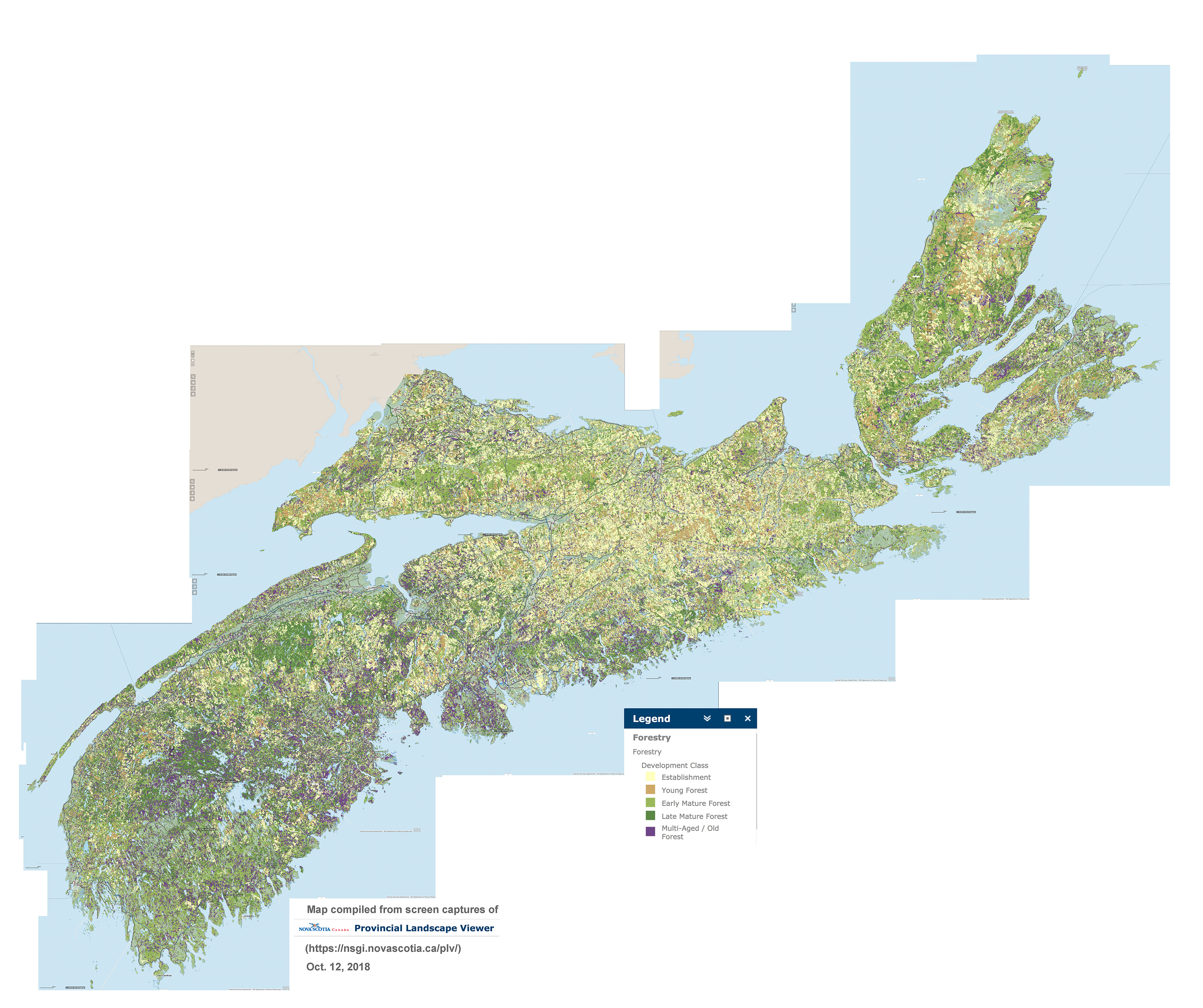
Distribution of forest in 5 development stages across Nova Scotia, compiled from NS Landscape Map Viewer. Purple = Multi-aged/Old Forest. View larger versions of the map: 2000 px | 4000 px.
(You may have to Save the larger image and open it on your device to view at full size).
More or less (and mostly more), the purple patches in the map above are also the forest stands with the highest wood volumes and likely correspond fairly well to many of the potential, high productivity, HPF sites cited in the HPF Discussion Paper. So clearly HPF could not be a major component of the 310,998 ha left for forestry.
So the land still available for forestry after assigning Crown lands to the additional 16% needed to reach 30% protection would be approx. 45% (310,998/687000 x100) of that available as the ‘working forest landbase’ currently.
These are back-of-the-envelop calculations performed to gain some sense of how much of our existing Crown lands would have to put into protected areas to achieve 30% protection for the province as a whole. In practice that would likely involve identifying a set of larger intact areas rather than a large number of small patches (e.g. such as wildlife habitat buffers) which is implicit in the tabulation above.
View Forest management (Nova Scotia)(federal website) for amount of land harvested. Latest figure listed is 31,151 ha for 2018; 2019 and 2020 likely higher as there were some restrictions while the Lahey Report was in progress. In 2016, 34,075 ha (both private and Crown lands).
2. How much of Nova Scotia was forested in pre-settler times?
Cira 90%. See Land base/Forest Land Capability
3. How much land was cleared and then later reverted back to forest?
The numbers are a bit all over the place. See Land base/Historic Afforestation
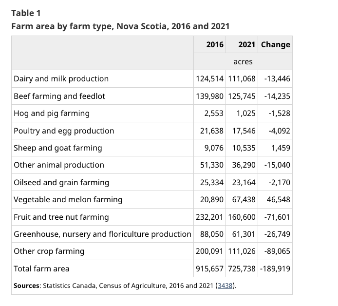
From the State of the Forest Report 2016: “Agriculture covers about 4.9 per cent of the province. As per Fernow (1912), agricultural lands once occupied roughly 900 000 ha of the province. Today, only a third of that area remains farmed.” So that would amount to 600,000 ha that were cleared and subsequently reverted to forest.
Over much of New England, as much as 75% the forested land which dominated the landscape when the settlers arrived was cleared, settled & farmed in the 16- 17- and 18-hundreds. With increasing urbanization and intensification of agriculture in the late 1800s to the early to mid 1900s, much of the agricultural was largely abandoned and reverted to forest, making eastern North America one of the few areas where there has been large scale net gain in forest cover in recent times [Thompson et al.,2013].
In contrast, in Nova Scotia, agriculture has been limited by poor or very rocky soils over much of the province and much of the province has remained forested throughout this time. Today forest cover is about 75%, down from ~85% in pre-settler days. 4.9% of the province is farmed, down from ~15% in the early 1900s. (View State of the Forest Report 2016). Most of the difference, about 500,000 ha, is now in Old Field forest succession; it was forested land cleared for agriculture and settlement, but now reverting to forest.
4. How much Old Growth do we have in NS?

Provincial Forest Area more than 100 years old, Percentage of Total Forest Area, 1958–2003 From GPI Atlantic 2008
It is difficult to find firm numbers for the percent of our forest that is Old Growth (forest 125 years of age and older). Something under 0.3% is commonly cited, e.g. as cited at right.
So I posed this Question to Peter Bush at L&F on Nov 23, 2021:
Hi Peter, perhaps I missed it but I can’t seem to find this no anywhere in the proposed Old Growth policy.
So by current criteria (>125 years), can you say how much we have, documented of course, in hectares?
Response May 13, 2022:
Hi David
In part this is why it is a difficult question to answer.
I don’t feel that is appropriate to divide those numbers for several reasons
We have not sampled the population in any statistical way (no stratified random sample).
The 4,000 ha was based on a ballpark sample of maybe 20,000 ha (so similarly it would be wrong to suggest there is 20% old-growth in Nova Scotia)
Many of protected areas (~600,000 ha) were selected for protection because they had OGF (so not just a little bit more, for over 35% of provincial land).
1,824,000 is not the correct denominator (includes naturally non-forest areas).
We really haven’t been sampling in some of v-types listed in the new policy coastal, wet forests, etc.
4,000 ha is really just the amount of forest outside of protected areas that is known OGF (i.e., sampled OGF). We are fairly confident there is much more OGF on crown alone (why many original OF policy areas were selected), again we have not sampled most of these because they are already protected under the policy.
Mosseler, J.A. Lynds, and J.E. Major. 2003. reports an estimate range of 1-5% for OGF in Acadian Forest for NS. Until further research at the broad-scale has been concluded, we have no reason (or data) to support that this range is wrong. The old-growth policy acknowledges that OGF in NS has had significant decline and important to protect all remaining old-growth, no matter whether there is 1%, 3%, 5% or 9%.
5. How much Old Forest do we have in NS?
I can’t find a firm number for the amount of Old Forest (forest 80 years and older) in NS. Eyeballing the map above, I would guess about 15% pdf the area of forested land is Old Forest (on both Crown and private lands).
There is some confusion about what constitutes “mature forest” on maps of Forest Development Stage (see NSFN Post, June 7, 2022). In a 2020 report on Forest Connectivity in Nova Scotia by Dalhousie and L&F researchers, Mature Forest is defined as “those forests with a minimum age of 40 years (provided as a maximum stand height of 12m”. They comment that “mature forest classes were consistently ~40% for all REZs” (REZ is a Raod Effect Zone). So assuming about half of that is Old Forest, that would amount to 20%, in the same ball park as my eye-balled estimate of 15%.
Given the clear evidence we have now that Old Forests (80 years & older) are critical for conservation of biodiversity, it would be welcomed if NRR maps were to clearly define a category of Old Forest (forest known, or inferred based on multiple indices, to be 80 years of age and older), and include that as a new layer on both the Harvest Plan Map Viewer and the Provincial Landscape Viewer – and provide the related stats such as the amount of Old Forest for the province as a whole, and for Crown lands and Private lands considered separately.
6. How much Land is suitable for Agriculture
Source: Profile of Agricultural Land Resources in Nova Scotia
Prepared by:
Michael Devanney, Economist
Nova Scotia Department of Agriculture June 2010
Overview of land resources
Lands most suitable for agricultural production (Canadian Land Inventory (CLI) classes 2,3 and 41) cover slightly less than 30 percent of Nova Scotia’s land area (see Table 1). The province’s best arable land (CLI2) accounts for 3 percent of the land area, while CLI3 and CLI4 cover 18 and 8 percent, respectively. This land is not necessarily used for agriculture and may instead be used for urban development, for other economic uses, or exist in a forested/natural state.
Nova Scotia does not have any CLI class 1 soil. Class 2 to 4 soils have moderate to severe limitations that restrict the range of crops or require special conservation practices or both. Class 5 soils and below have very severe limitations for agriculture.
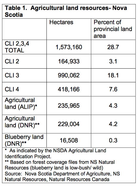 Approximately 235,000 hectares are used for agriculture (including blueberry production) as indicated by the ALIP project in 1998, amounting to 4.3 percent of the province’s area (Figure 1b). Agricultural land as identified by DNR forest inventory data amounts to approximately 229,000 hectares with a further 16,500 hectares estimated to be in wild blueberry production.
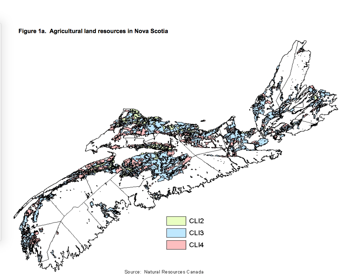
Land with suitability for agricultural production is concentrated in the Annapolis Valley, throughout most of Hants County, and along the Northumberland Strait. There are also significant concentrations in Digby and Yarmouth counties, in southern Inverness and around the Cape Breton Regional Municipality.

Usage of arable land and composition of farmed land
Approximately 13 percent of land most suitable for agricultural production (CLI classes 2, 3 and 4) is used for agriculture in Nova Scotia. Slightly less than 1 percent of this land is also used for wild blueberry production. Urban development takes up 5.4 percent of CLI 2,3,4 and the remaining 81 percent is in some other use (natural forest or other natural state, cultivated forest, etc).
For some recent stats on agriuclture in NS, see Canadian Agriculture at a GlanceLowbush blueberries, apples, mink and poultry play a large role in Nova Scotia farming Star Canada June 15, 2022