
This page provides an overview of spatial and forest age issues.
- View Conservation Links for subsidiary issues and information about individual species; also links under Natural History
- View also NSDNR Old Forest Policy
- View also Birds
Also view:
– Plourde urges Premier to reset the agenda on nature for Nova Scotia 13Oct2020
Post on NSFN Oct 13, 2020
– Response to Workshop on DNR’s Framework for Ecosystem-Based Forest Management (including DNR’s Work on Natural Disturbance Regimes)
Karen Beazley. A submission to Nova Scotia Forest Practices Review, March 18, 2018. This document provides a lot more detail, references etc on the subject matter of this page. Also view publications by Karen Beazley on Google Scholar
– Letter to Nova Scotia Forest Practices Review from Art Lynds, Feb 19, 2018
Posted with permission of Art Lynds. A critique of DNR’s interpretations and representation of natural disturbance regimes in NS forests
– OGF submission to Prof. Lahey March 20 2018
by John LeDuc (posted with permission) A critique of NSDNR’s Old Forest Policy
– You can also view John LeDuc’s Full three part Submission to Nova Scotia Forest Practices Review March 2018
– Submission by Dale Smith to Independent Review
A Follow-up to December 11, 2017 Meeting and Discussion
———————————-
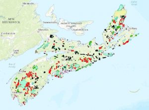
Parks and Protected Areas in Nova Scotia as of Dec 29, 2015. Click on image to go to interactive map.
Under EGSPA (the Environmental Goals and Sustainable Prosperity Act, passed in 2007) Nova Scotia committed to protect at least 12 per cent of its land area by 2015. By the end of 2015, 12.26% was protected. With new designations in March of 2017, that figure rose to about 12.39%, in 2019 to 12.72% and in Oct 2020 to 12.83%.
The 12% figure, however, should be seen as a waypoint, not an endpoint. This figure has its origin in The World Commission on Environment and Development Report, Our Common Future (1987)1,2. The report called for at least tripling the expanse of protected areas which then stood at about 4% globally. Tripling seemed politically feasible, but this target was cited as a minimum and was not based on formal considerations of the area required to sustain species and ecosystems.
FRAGMENTATION
Our Parks and Protected Areas are highly fragmented. Habitat fragmentation is responsible for more than 80% of biodiversity losses. Hence, at best, protecting 12% of habitat while larger areas continue to degrade will help only to stem the tide, not to stop it or reverse it.
We are only just at the beginning of large scale species losses associated with fragmentation of habitat. The alarm bells about species loss were raised in the 1980s because of losses that had occurred until then and, more so, because a better theoretical understanding of species biodiversity predicted huge losses to come with continuing destruction and fragmentation of habitats. E.O. Wilson’s rule of thumb predicts that a tenfold reduction in habitat results in approximately 50% reduction in the number of species an area can support. Many or most species may hang on in a remnant habitat for a while, but are lost as they become locally extinct and cannot be replaced by immigration from other, still extant populations in other suitable habitats.
The analogy I like to use to explain why fragmentation is so detrimental to conservation is zoos. If we have a small zoo with only one individual of species X in the zoo, that zoo is more likely to lose species X than another, larger zoo which has a dozen individuals of species X. Likewise, small, isolated patches of natural habitat are more prone to completely losing a species than larger pieces of natural habitat. (They can also support fewer different species in total than larger patches.) In a zoo when some or all individuals of a particular species are lost, the zoo can often get replacements from other zoos; they may also get sperm from males in other zoos to fertilize a female in order to increase the genetic diversity of a particular species in the zoo. In nature, such exchanges can occur only if it’s possible for species to migrate between patches, i.e. there is some connectivity between patches. Flying species are less dependent on a high degree of ground connectivity between habitat patches but may still require places between habitat patches where they can get water and food or escape predators.
So, in addition to conserving as much intact habitat as possible, we need to reconstruct a network of habitats and “wildlife corridors” across the whole province in order to maintain some movement and gene flow between populations in different regions. This is true not only for large species like the mainland moose, but for all animal and plant species.
HOW MUCH LAND DO WE NEED TO MANAGE FOR BIODIVERSITY CONSERVATION?
A study by Karen Beazley and associates in the School for Resources and Environmental Studies at Dalhousie used a GIS and modelling based approach to estimate conservation needs in Nova Scotia3. They concluded that ~60% of Nova Scotia, including 32% in core areas, should be managed for conservation objectives to maintain genes, species, and ecosystems over time. Similar estimates have been forthcoming from other studies. In practice this means that much larger areas than 12% of the province need to be managed for biodiversity conservation, regardless of whether they are in private or public hands.
FORESTED LAND IS KEY
Approximately 79% of the land area of Nova Scotia is forested today, perhaps over 95% historically. So how the forest is managed outside of the Parks and Protected Areas is critical for biodiversity conservation in Nova Scotia.
That’s also why we need to have as clear an understanding as possible of the natural disturbance regimes.
It is possible to have economically productive forests that also contribute to the to the ~60% that needs to be managed for biodiversity – but not by managing 85% of our working forests on 50 year rotations! It takes about 150 years following a disturbance for Acadian forest to and develop a multiage structure and reach its maximum wood volume, longer to develop an old growth structure with a high volume of snags (standing dead trees) and coarse woody debris (fallen dead trees), important for many wildlife species.
One indicator of how well our forest management replicates natural disturbance regimes is the percentage of forest that is in the older growth stages.
In 1958, forests more than 80 years old covered 25% of the province’s forest area. Today they cover only 1% of forest area. Forests more than 100 years old covered 8% of the province’s forest area in 1958; today they cover only 0.15% of forested land. – The Nova Scotia GPI Forest Accounts Volume 1: Indicators of Ecological, Economic & Social Values of Forests in Nova Scotia (2001)
In pre-Columbian times, old growth forest likely occupied about 50% of the forested area4. So by this metric we are not doing well! The other 50% was in earlier successional stages following (mostly small scale) disturbances.
Another important indicator is the cover by “intact forest landscapes”.
An intact forest landscape is a contiguous mosaic of naturally occurring ecosystems in a forest ecozone that is essentially undisturbed by significant human influence visible on Landsat satellite images. An intact forest landscape does not necessarily consist of old-growth trees and may not even be entirely forested—it may consist of a mosaic of natural ecosystems, including forest, bog, water, tundra and rock outcrops. – Nova Scotia’s Intact Forest Landscapes: Opportunities for Conservation PlanningGlobal Forest Watch Canada document (2010-11-26)
In 2007, that stood at 17% of Nova Scotia. The Global Forest Watch study commented: “there are several opportunities in Nova Scotia to protect large intact forest landscapes larger than 20,000 ha.” One of these was in the Chignecto area. Subsequently the Kelly River (21000 ha) and Raven Head (5,650 ha) Protected Areas were established – but in Raven Head, about 1/3 of the area was clearcut as part of the land acquisition deal; most of the area was already 2nd growth after earlier clearcuts. These big forestry/pulp and paper concerns that we entice to take up shop in Nova Scotia with all kinds of deals are hardly equally generous when they finally pull up stakes.
1. Report of the World Commission on Environment and Development: Our Common Future. (1987). Transmitted to the General Assembly as an Annex to document A/421427 – Development and International Co-operation: Environment. Retrieved from http://www. UN-documents.neVocf-06.htm.
2. Wiersma, Y. E, & Nudds, T. D. (2005). Qn the fraction of land needed for protected areas. Chapter 7 in N. Munro et aJ. (eds). Making ecosystem based management work: Proceedings of the fifth annual conference of the Science and Management of Protected Areas As-sociation 2003. Science and Management of Protected Areas Association. Retrieved from http://www.mun.cal biology/ywiersmalwiersmanudds_sampaa.pdf.
3. Beazley, K. et al. 2005. Biodiversity considerations in conservation system planning: a map-based approach for Nova Scotia Canada. Ecological Applications 15(6): 2192-2208
Abstract. Biodiversity considerations in conservation system planning include three main criteria: representation, special elements, and focal species. A GIS-based approach utilizing simple models was used to assess existing biophysical data relative to these criteria for conservation system planning in Nova Scotia, Canada, with potential utility in applications elsewhere. Representative samples of natural landscapes were identified on the basis of size (= or > 10 000 ha) and degree of naturalness (natural cover, uneven-aged forests, low or zero road density). Special elements were selected, including hotspots of diversity and rarity, critical habitat for species at risk, significant wetlands, old and unique forests, and ecosites. Habitat requirements of viable populations of focal species (American moose, American marten, and Northern Goshawk) were identified using species distribution data, habitat suitability, and population viability analyses. Priority core areas for biodiversity conservation system planning were identified on the basis of these three sets of criteria. Key areas of habitat connectivity were delineated by selecting the least-cost paths for focal species between relevant core areas through costdistance analyses based on habitat suitability, road density, and minimum corridor width. Collectively, these biodiversity considerations indicate that ;60% of Nova Scotia, including 32% in core areas, should be managed for conservation objectives to maintain genes, species, and ecosystems over time. Although data and modeling limitations require that our analysis of richness and diversity, habitat suitability, population viability, and core area selection be verified, the area calculations and other results are consistent with those in similar studies. Consequently, the system design and other information generated are useful for local and regional biodiversity conservation planning and management, and the methodological approach is of potential use in other regions where the necessary field-based data may be made available.
4. Mosseler et al. 2003. Old-growth forests of the Acadian Forest Region. Environmental Reviews 11: S47–S77.
—
View also
Habitat fragmentation and its lasting impact on Earth’s ecosystems
Nick M. Haddad et al. 2015. Science Advances 2015 Mar; 1(2). ABSTRACT: We conducted an analysis of global forest cover to reveal that 70% of remaining forest is within 1 km of the forest’s edge, subject to the degrading effects of fragmentation. A synthesis of fragmentation experiments spanning multiple biomes and scales, five continents, and 35 years demonstrates that habitat fragmentation reduces biodiversity by 13 to 75% and impairs key ecosystem functions by decreasing biomass and altering nutrient cycles. Effects are greatest in the smallest and most isolated fragments, and they magnify with the passage of time. These findings indicate an urgent need for conservation and restoration measures to improve landscape connectivity, which will reduce extinction rates and help maintain ecosystem services.
Four decades of fragmentation
Post on ConservationBytes.com. A quick overview of some of the results from the Biological Dynamics of Forest Fragments Project, “unquestionably one of the most important landscape-scale experiments ever conceived and implemented”.
A life of fragmentation
Post on ConservationBytes.com, May 9, 2018
Laurance’s focus on fragmentation – or, as I’ve decided to call it, Fragmenfocus – led him down a fruitful path of ‘apple on the head’ discoveries. One critical development in his, and indeed everyone’s, understanding of the wider impact of fragmentation came with his 2002 paper [error: it was 2009] ‘Hyperdynamism in fragmented habitats’. This looked at how ecological processes are affected and why species respond in the ways they do.
“Imagine taking some really strong amphetamines,” says Laurance, when I asked him to explain the term for us, “and then seeing what it does to your physiology and health. That’s more or less what the hyperdynamism hypothesis postulates for fragmented ecosystems. For lots of reasons, their dynamics go wacky and generally speed way up.
“For example, the dynamics of habitat fragments can be accelerated by recurring disturbances from fires and windstorms originating outside the fragments.
Invasive or generalist species can explode in numbers in the modified lands surrounding fragments and then invade them, knocking them off-kilter. Trees near fragments die much faster than normal—due to microclimatic stresses and wind shear. And small fragments have small, vulnerable populations of native plants and animals that are inherently vulnerable to random fluctuations.”
If that wasn’t pointed enough, he adds this:
“Beyond all that, fragmented habitats also tend to be logged, hunted, polluted, or otherwise affected by human pressures. It’s no wonder that their dynamics are off-kilter.”
The Precautionary principle in biodiversity conservation and natural resource management: An issues paper for policy-makers, researchers and practitioners
Rosie Cooney 2004 Technical Report IUCN Policy and Global Change Series No. 2
Virtual Fences for Wildlife Crossings
Accessed Apr 18, 2020. Developments in Australia; early models commercialized.
Targets:
Aichi Target 11