
Nova Scotia Soil Quick Facts
Perennia Field Services Fact Sheet. Document is dated 2018-02-22
Forest Soil Types of Nova Scotia Identification, Description, and Interpretation
Kevin Keys 2007 NSDNR
Forest Ecosystem Classication for Nova Scotia Part II: Soil Types
Kevin Keys, Peter Neily, Eugene Quigley. 2010. Nova Scotia Department of Natural Resources Renewable Resources Branch
Soil Survey Reports for Nova Scotia
Canada.ca/Agriculture and Agri-Food Canada/Agriculture and the environment/Soil and land/CanSIS/Publications/Soil Surveys
Lists under 4 sections:
Detailed and Very-Detailed Soil Survey Reports
Reconnaissance Soil Surveys
Special Reports
Archival Soil Survey Reports (1943 – 1950)
Using historic soil survey data to map water erosion hazard for land-use planning in Nova Scotia
Kevin Keys et al., 2015 Canadian Journal of Soil Science “A fine-scale digital soil map layer for Nova Scotia was combined with historic soil survey information and digital elevation (DEM) data to generate a new water erosion hazard map based on inherent soil erodibility and slope class. Results showed approximately 62% of Nova Scotia has low erosion hazard, 33% has moderate hazard, and 5% has high hazard. The erosion hazard map was subsequently used in a provincial watershed assessment program (NSWAP) to map potential water quality stressors related to land-use patterns on erodible soils. This work is an example of how historic soil survey data can be utilized to create new information for land-use planning and environmental assessment.”
Nova Scotia Pre-Treatment Assessment Reference Viewer
Currently (Apr 3, 2018) this provides Wind Exposure 2017; and FEC Soil Type Layers.
To view the Arc GIS version (for which you need user/pwd), go to this link
A Simple Geospatial Nutrient Budget Model for Assessing Forest Harvest Sustainability across Nova Scotia, Canada
Kevin Keys et al., 2016.Open Journal of Forestry > Vol.6 No.5,
A geospatial GIS-linked spreadsheet model (Nutrient Budget Model—Nova Scotia: NBM-NS) was developed for Nova Scotia to assess the long-term sustainability of forest harvest scenarios as constrained by primary nutrient inputs and outputs due to atmospheric deposition, soil weathering, and leaching. Harvest scenarios refer to user-defined stand-specific removal rates of bole wood, bark, branches, and foliage, based on current or projected forest inventories. These scenarios are evaluated within the context of existing data layers for current climate (mean annual precipitation and air temperatures), atmospheric deposition (N, S, Ca, Mg, K), and soil/substrate types, supplemented by species-specific look-up tables containing expected biomass fractions and nutrient concentrations. This article introduces this model to assess relative site quality and limiting nutrients for red spruce and sugar maple across Nova Scotia. This is followed by an output comparison involving 25 spruce plantations whereby NBM-NS determinations derived using “default” soil survey data are compared with those derived using plantation-specific soil data. Model output shows that (i) Ca and N are the main growth-limiting nutrients across Nova Scotia, (ii) currently projected plantation yields are generally not sustainable on sites underlain by slowly weathering soils, (iii) current soil base cation contents are generally lower than what is reported in historic soil survey reports, and (iv) model results are expected to vary within the context of changing climate, acid deposition levels, and data accuracy.
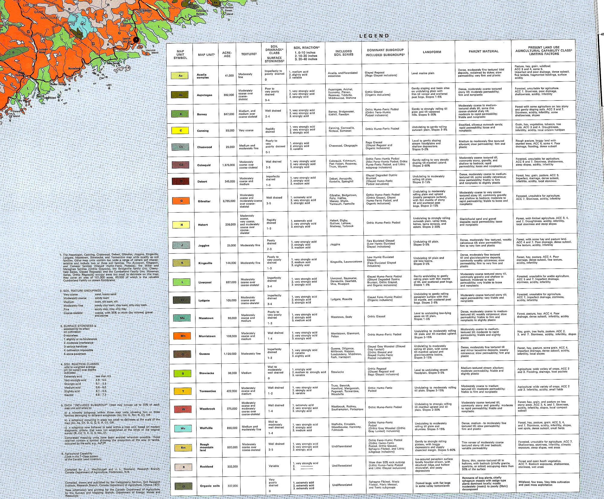
Soils of Nova Scotia
1972 Map Canada.ca/Agriculture and Agri-Food Canada/Agriculture and the environment/Soil and land/CanSIS/Publications/Soil Surveys/NovaScotia. 10510x7772px.
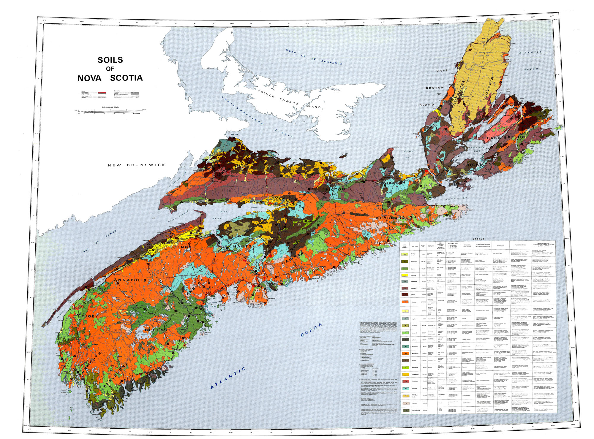 Click on map for larger (2000 px wide) version. Go to Ag-Canada site for 10510 px wide version. View Legend
Comment:
Over much of New England, as much as 75% the forested land which dominated the landscape when the settlers arrived was cleared, settled & farmed in the 16- 17- and 18-hundreds. With increasing urbanization and intensification of agriculture in the late 1800s to the early to mid 1900s, much of the agricultural was largely abandoned and reverted to forest, making eastern North America one of the few areas where there has been large scale net gain in forest cover in recent times [Thompson et al.,2013].
In contrast, in Nova Scotia, agriculture has been limited by poor or very rocky soils over much of the province and much of the province has remained forested throughout this time. Today forest cover is about 75%, down from ~85% in pre-settler days. 4.9% of the province is farmed, down from ~15% in the early 1900s. (View State of the Forest Report 2016). Most of the difference, about 500,000 ha, is now in Old Field forest succession; it was forested land cleared for agriculture and settlement, but now reverting to forest.
State of the Forest Report 2016
Lands
The vast majority of our province is forested. In fact, land use areas (Figure 1.1) show that over 75 per cent of Nova Scotia’s 5.5 million hectares (ha) are dominated by treed vegetation. These 4.2 million ha of forested lands also include areas that are returning to a young forested state after harvesting or for which there is no sign of permanent forest removal by agriculture, urbanization, or other anthropogenic (human induced) development. Approximately 7.8 per cent of the province is composed of naturally occurring non-treed ecosystems such as shrublands, beaches, and open woodlands primarily covered by small woody vegetation and herbaceous species. Coastal and inland wetlands account for about 2.9 per cent of the province. Agriculture covers about 4.9 per cent of the province. As per Fernow (1912), agricultural lands once occupied roughly 900 000 ha of the province. Today, only a third of that area remains farmed. The remaining 4.4 per cent of our province encompasses urban areas, the provincial transportation network, and anthropogenic non-forested lands. Urban areas (2.8%) are defined as any area used primarily as residential, industrial, and where related structures such as streets, sidewalks, parking lots, and housing developments prevail. The transportation network (1.1%) is composed of roads, rails, electric transmission corridors, and pipeline corridors. The anthropogenic non-269,5000forested land use category (0.5%) is composed of mines, landfills, quarries, and other features.
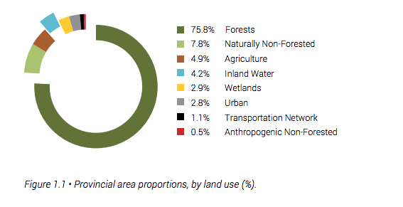
Comments. The sum of the percentages for Non-forested, Inland Water and wetlands is 14.9%. Thus the pre-Columbian forest percentage is estimated as 100-14.9=85.1%.
The acreage given in Fernow (2012) pages 17&18 for farmed land is 1,832736 acrea=741,682 ha, not the 900,000 ha cited above. It is stated above that “Today, only a third of that area remains farmed”, which based on 900,000 ha would be 300,000 ha. Above the percentage of land in Agriculture is given as 4.9%, which would be 0.049 x 5,500,000=269,500 ha, which is 36.3% of Fernow’s 741,682 ha.
Fernow Farm (Cleared) land – Current Agriculture Land= 741,682 ha-269,500 ha = 472,182 ha. So this is an estimate of the land that is currently re-foresting from land once cleared in NS. It is equivalent to 8.6% of the total area of NS.
Fernow’s cleared area, 741,682 ha is equivalent to 13.5% of the total area of NS. So the Percentage of forested land in the time of Fernow is estimated as 85.1%-13.5%=71.6% From that should subtracted a further X%to account for habitations, roads, other non-agricultural use of land (today it is 4.4% of total land area, so, e.g. if it were 3%, that would make the forested area 68.6% of the total land area
| In summary, the pre-Columbian forest cover was approx 85% of the total area (land + inland water & wetlands). The non-forested area was made up of naturally non-forested land, open water and wetlands. By the time of Fernow, forest cover was reduced to ~68%% of the area. Currently, forest cover is approximately 75.8% of the total area, agriculture 4.9%, and human-utilized land other than agriculture and forestry, 4.4% of the total land area. |
In contrast, much more of the land was cleared from forest in New England – as much as 75% of some states – but as in NS “over the last 150 yr, much of the land cleared for agriculture has reverted to forests” (literature reviewed in Richardson et al., 2014).