
Clearcutting close to the pending Shingle Lake Nature Reserve illustrates transparency issues & raises questions about landscape level planning for biodiversity conservation in Crown land harvest decisions
This is a lengthy post, so I am inserting a Summary & Table of Contents.
Summary
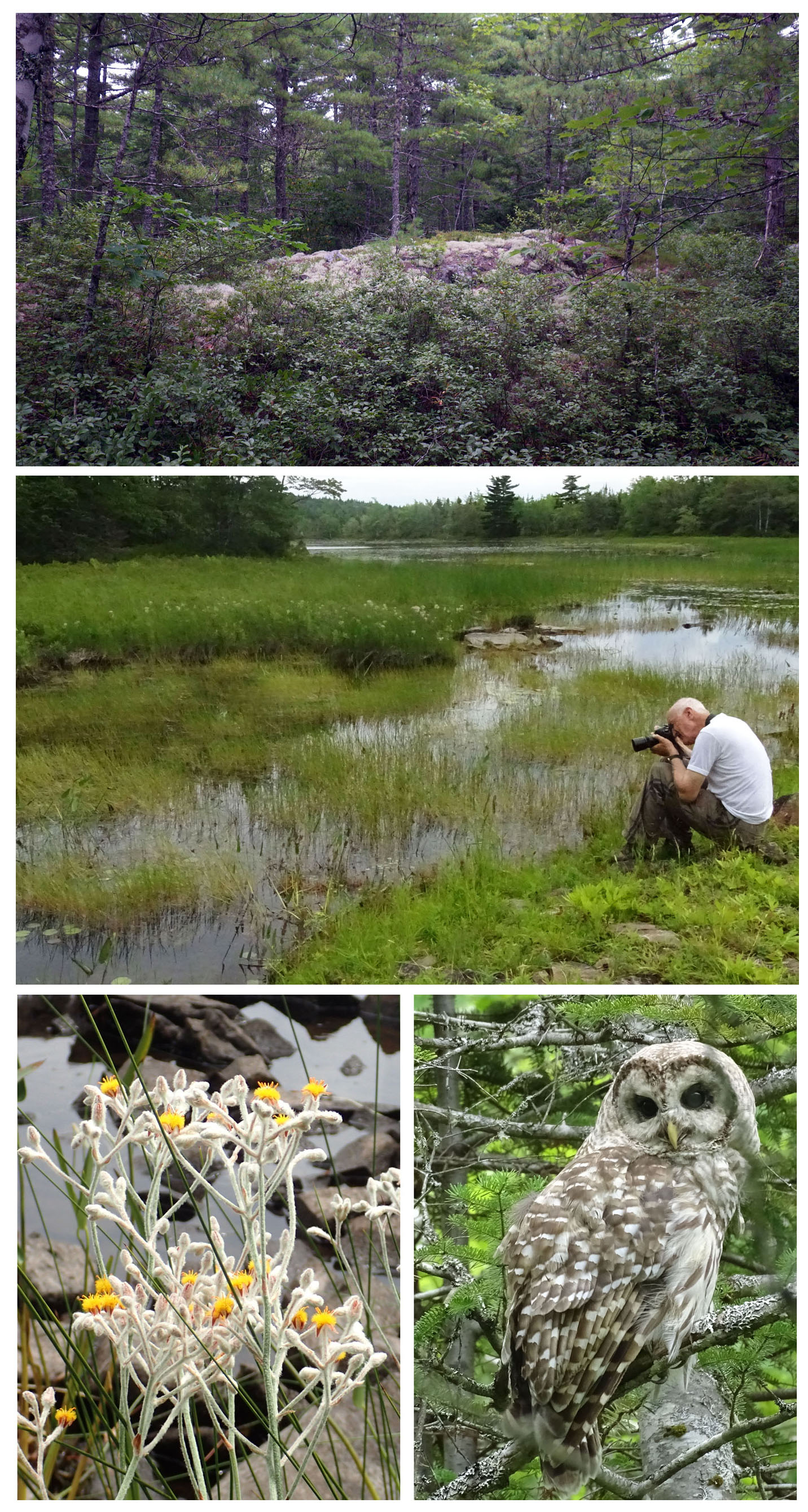
Shingle Lake Nature Reserve (pending) Band of rocky outcrop in forest (Top); naturalist photographs insect activity in lakeside wetland (Mid); Golden Pert & Barred Owl (Bottom)
Click on image for larger version
The HPMV and related notifications from NSDNR provide information about particular proposed harvests on particular sites in the immediate future, but relevant information about longer term plans by the Licensee and about landscape level forests characteristics and DNR planning for such things as landscape connectivity is lacking.
There appear to be few brakes on massive cutting of the still relatively abundant old, multi-aged forest in much of SW Nova Scotia, our “last great wood basket”.
Contents
- Introduction
- The pending Shingle Lake Nature Reserve is not identified on the HPMV
- What are the longer term plans?
- Completed harvests on Crown land should also be shown on the HPMV
- Harvests on private lands are also relevant
- What is being cut? What’s the larger picture?
- What landscape level planning is involved in approving proposed cuts?
- About the pending Shingle Lake Nature Reserve
Introduction HPMV info on Block LUO682322.
Recently there was a bit of an e-mail flurry amongst some of my naturalist friends when a couple of them reported that “[as we headed] to Ash Brook Saturday and passed Medlee Lane on route 325, the way in to Shingle Lake, [we] noticed brush cutters widening the entrance to the old road in to the lake. On our return we were shocked to see a sign that read WestFor, the logging consortium company. This means that this group will clearcut all the land to the edge of the protected area around Shingle Lake. This is a place that is quite isolated and there will undoubtedly be an impact on fishing camps and private cottages at the lake. I am asking you all or at least some of you to write your MLA or whomever is appropriate…” 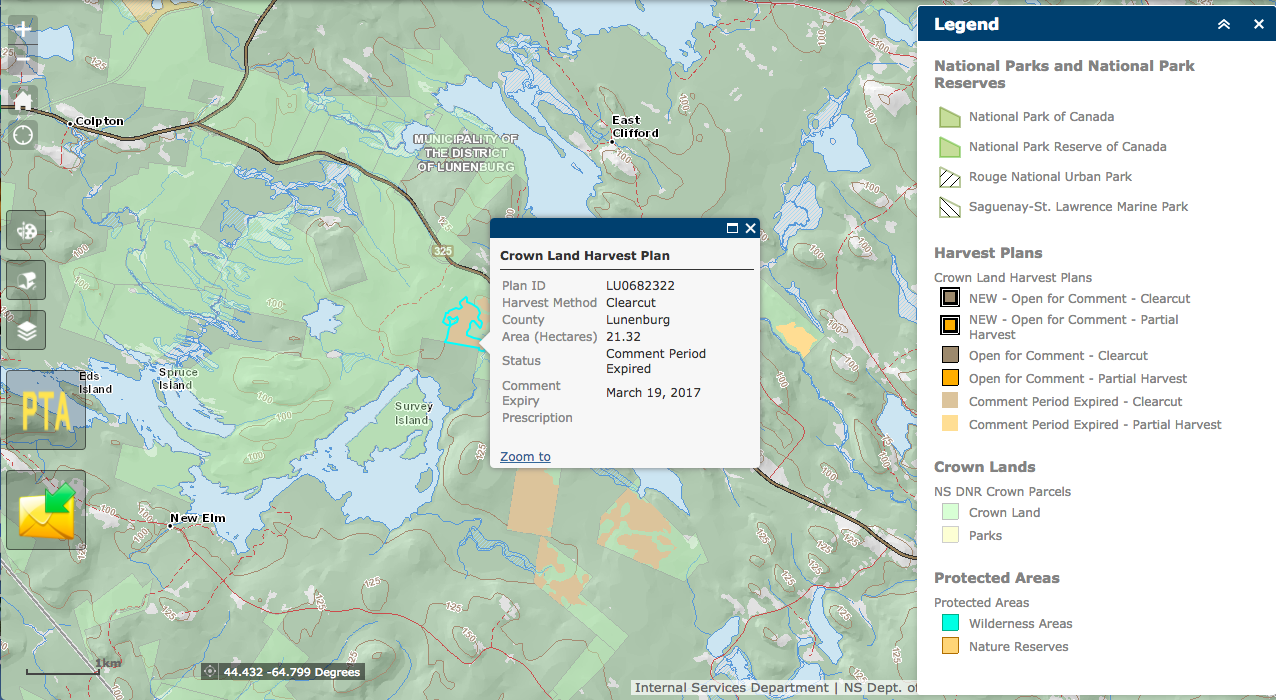
Crown land is shown but the pending Shingle Lake Nature Reserve is not identified.
Click on image for larger version.
The pending Shingle Lake Nature Reserve is not identified on the HPMV
The cut is about 500 m from Shingle Lake itself, but the Shingle Lake “protected area” was not showing up on the Harvest Plan Map Viewer (HPMV). So I checked the area out on the Nova Scotia Parks and Protected Areas Interactive Map; there, the pending Shingle Lake Nature Reserve is shown. (Apparently they are placed on the HPMV only when they are finally designated.)
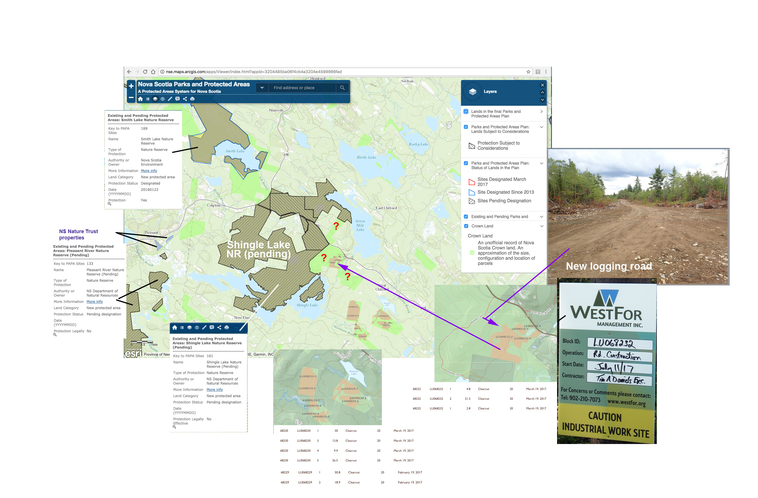
Locations of planned cuts in relation the pending Shingle Lake Nature Reserve. The map was constructed by combining elements from the Harvest Plan Map Viewer and the Nova Scotia Parks and Protected Areas Interactive Map, adding info from the Updates Notifications, a photo of new logging road (July 29, 2017) and a photo of WestFor sign on Medlee Lane (July 22, 2017).
Click on image for larger version. (You may have to click 2X for largest version.)
As well as the pending Nature Reserve, what’s not shown by the HPMV info is the longer term plan for cutting on Crown land in this area. Once working in an area, the mills/contractors seem to keep on going as illustrated by cutting on Crown land NE of Halifax, & presumably would want to do so here, possibly taking them right up against the pending NR (see map above), as my colleagues surmised. It seems unlikely that the new road was constructed with LU0682322 alone in mind.
One would think that the longer term planning is relevant to whether NSDNR approves a cut on Crown land initially and whether concerns are received from the public once it is posted, i.e. for full transparency, we should be seeing the longer term plans on the HPMV, a point made by Eric Zscheile in relation to NSDNR negotiations with the Mi’kmaq community concerning the Western Crown Lands:
We want the company to post their operational plans well in advance, not just 60 days in advance but about a year in advance, so that people in the community can look…and then have the ability to let government and the company know about any problems they see with that particular operational plan.
Completed harvests on Crown land should also be shown on the HPMV
This raises another issue. Plans which have already been harvested are now being removed from the HPMV, which is another set of information one would think is is pertinent NSDNR’s approval of a proposed cut initially and whether concerns are received from the public once it is posted. To the public viewer, they can reveal a pattern in the cutting such as the direction it seems to be taking.
Harvests on private lands are also relevant
Thinking about it further, I wondered whether NSDNR takes into account harvesting on private lands in an area when it gives initial approval to a proposed cut on Crown land. The pattern of all cutting affects connectivity between protected areas for example. Taking Shingle Lake as an example, I checked out Forest Cover Losses (mostly related to clearcutting since 2001) and Gains (mostly related to older clearcuts) on the Global Forest Watch Interactive Map.
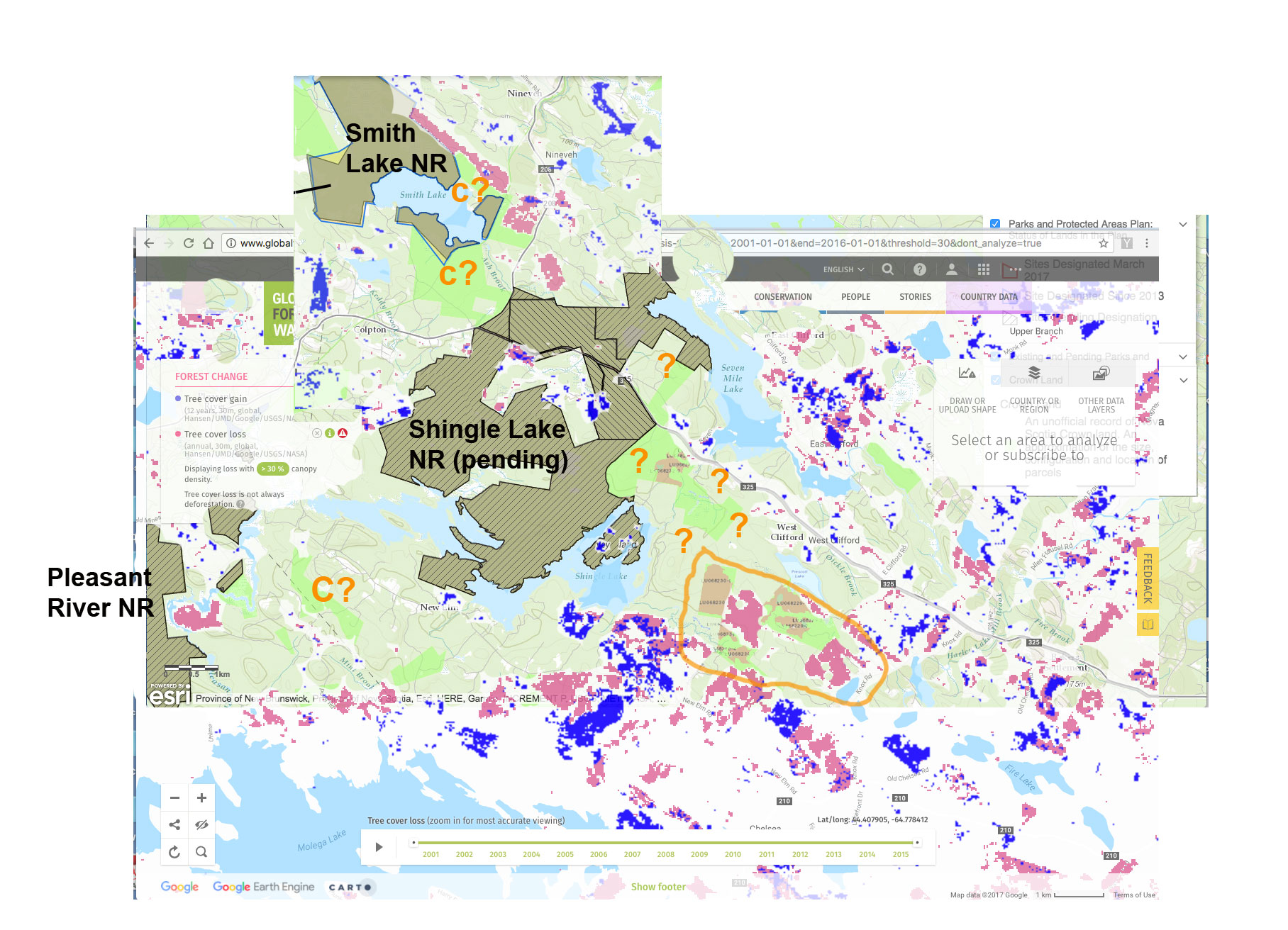
Recently planned Crown land cuts from the HPMV, and Tree Cover Loss (2001-2015)/Tree Cover Gain (2001-2015, most is in clearcuts made prior to 2001) from Global Forest Watch Map copied onto onto the NS Parks and Protected Areas map.
The map at right is a rough attempt to show (from several sources) the existing and pending protected areas, Crown lands, recently planned cuts on Crown land, and all cuts in the area including those on private lands.
The map shows a lot of cutting to the SE of Shingle Lake NR on both Crown and private lands. In the area circled, it shows close juxtaposition of planned cutting on Crown land and cutting on private lands. That would make sense in relation to costs of road construction etc., but it also results in pretty dense cutting.
Given this pattern and that the LU0682322 site is a bit of jump to the NW towards the Shingle Lake Nature Reserve, it seems a good guess that the forestry companies intend to move in that direction (i.e. into the areas with ? marks on the map above) on both private and Crown lands.
The C? marks on the map above are Crown land pieces that provide some landscape connectivity* between the Shingle Lake Nature Reserve and two other Nature Reserves in the area. So… what’s the plan for future cutting NSDNR? Is there one that you know about? Can you share it with the public? Are you going to put restrictions on Crown lands that provide some connectivity, especially given the density of cutting on private lands which you don’t want to regulate in any way?
*Landscape Connectivity. Connectivity refers to the movement of organisms and processes (eg. disturbances) and the features that affect this movement. Movement is one of the most basic ecological functions, and should be well described and understood. The ability to move without excessive risk is of critical importance for maintaining biodiversity at all levels (genetic, individual, species, population, metapopulation, community, and ecosystem)…The primary strategy is to conserve natural connective function by sustaining and restoring natural patterns, particularly within the most important connective features. The focus of planning should be to recognize the most important connective systems, and remove or mitigate unnatural barriers to their function. From: A Procedural Guide For Ecological Landscape Analysis, NSDNR 2008, pp 6-7.
What is being cut? What’s the larger picture?
To get a little more perspective, I looked at Nova Scotia Landscape Map Viewer. This is a very powerful and robust tool, evidently maintained by the same group that maintains the HPMV as it has the same format, agreement form etc. It has many layers under the top Forestry Layer. I looked at “Development Class” which provides the following categorization of the forest cover:
This layer describes the structure of forests as they age and grow (e.g. forest establishment, young forest, mature forest).
Four development classes describe the structure of forests as they age and grow. Assignments are based on stand height:
- Establishment (Height 0-6m): Influx of new growth following a stand initiating disturbance, and characterized by a high diversity of forbs, shrubs, and tree regeneration.
- Young Stem Exclusion (Height 7-11 m): Young developing tree canopies characterized by vigorous self thinning, crown differentiation, and competitive exclusion of many individuals.
- Mature (Height > 11 m): Stands dominated by upper canopy trees with full differentiation into dominance classes. Canopy gaps are soon closed by neighbouring tree growth.
- Multi-age and Old Growth (Age 999 and Old Forest Policy) [“multi-age/old forest” on map legends]: Overstory exhibiting a variety of crown sizes and canopy densities. Canopy gaps are persistent promoting multi-layered understory development and recruitment to the overstory.
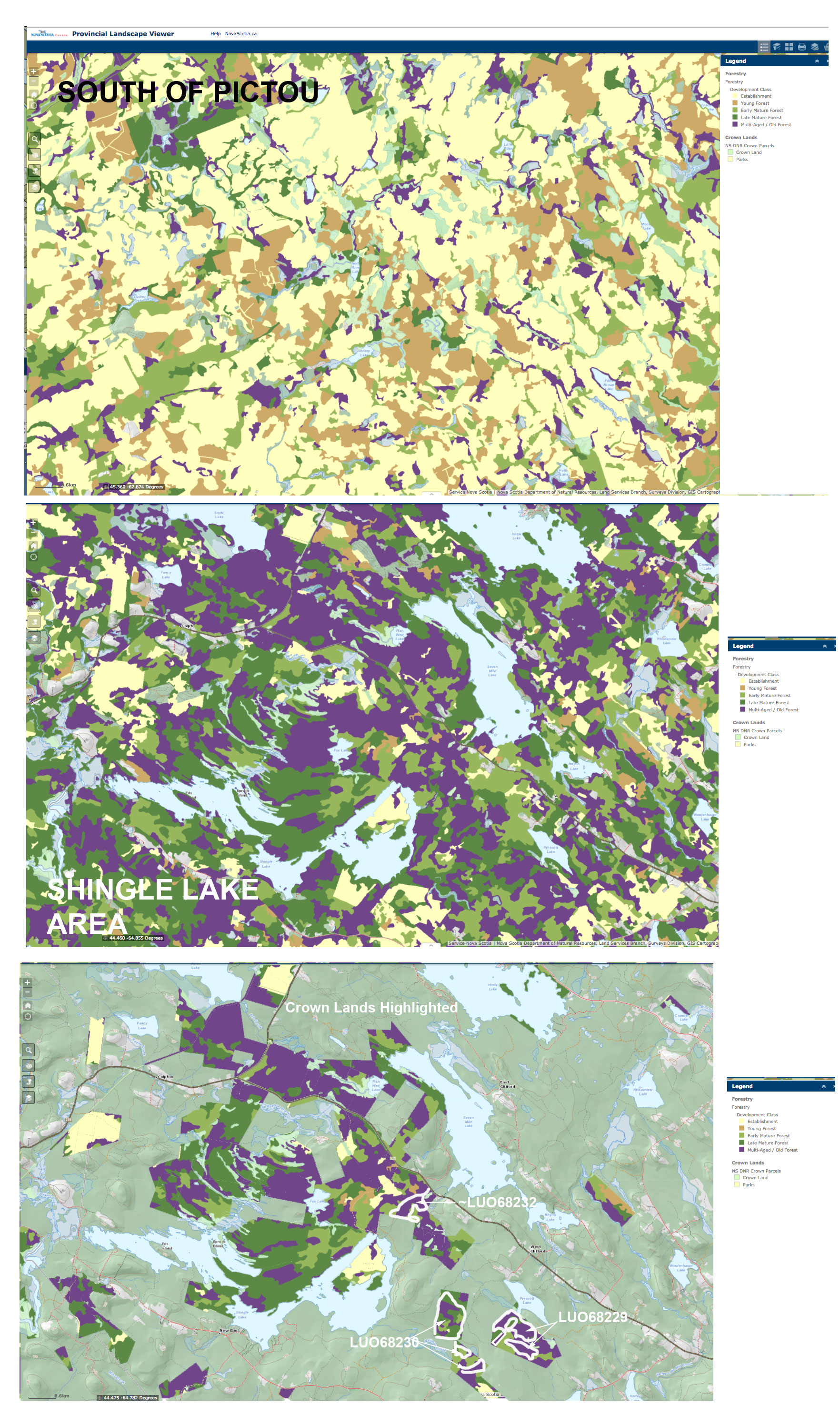
Forest Development Class for:
– an area south of Pictou (Top image) typical of much of central/eastern NS;
– the area of Shingle Lake in SW NS (Middle image);
– Crown lands only in the area of Shingle Lake (Bottom image).
The approximate areas of recently planned cuts are are circled. The purple patches are multi-age/old forest.
(From Nova Scotia Landscape Map Viewer)
(i) There is a lot of multi-aged, old forest in the vicinity of Shingle Lake, and much more than in a typical view in central/eastern Nova Scotia. (Compare the top two images at right.) Extensive conversion of such forests surrounding the protected areas in SW Nova Scotia will essentially isolate populations of many species dependent on mature, older forests
(ii) The recently approved clearcuts on Crown land in the area of Shingle Lake include large chunks of multi-age/old forest (view bottom image). If my interpretations are correct I find this shocking. What reasons would there be for NOT requiring selection cuts?
I appreciate this is not “all of the story”, but the way it looks (and I didn’t set out looking for this result) is that what we are seeing in the area of Shingle lake is the mowing down of multi-aged/old forest in SW Nova Scotia that has already taken place in a lot of central and eastern Nova Scotia. (When I say “mowing down”, I am referring to clearcutting/even aged management on short rotations.) As Matt Miller has described it in 2014, the Western Crown Lands are “the last great wood basket” not committed to pulp companies”, except now they are, at least they are to mills that are still clearcutting, even if they have no market for the smaller stuff.
In addition to consulting the HPMV and notifications, the story that I have been able to glean (to the extent it is correct) required reference to (i) Nova Scotia Parks and Protected Areas Interactive Map, to view pending protected areas;
(ii) Global Forest Watch Maps to to get some idea of past cutting regardless of ownership;
(iii) the Nova Landscape Maps Viewer to get some idea of the nature of the forests.
It also required considerable time and some minimal skills with Photoshop to combine screen captures from the different maps (I have no skills in GIS). So it is in this context that I am suggesting the process of Crown land harvest decisions has some way to go to be fully transparent to most Nova Scotians. We are given information about particular proposed cuts on particular sites in the immediate future, but information about longer plans by the Licensee and about landscape level processes and DNR planning for such things as landscape connectivity is lacking.
I suggest that the layers of the HPMV could be combined with those of the NS Landscape Maps Viewer to move more in that direction, which I surmise would not be a big deal because they appear to be pretty similar in their mechanics currently.
What landscape level considerations, if any, are involved in approving proposed cuts?
I do have to wonder what landscape level considerations are involved in NSDNR approving (or not) cuts proposed by Licensees, i.e. what is involved in steps 2 & 6 in the process for posting and approving cuts as outlined by Bruce Nunn for Linda Pannozzo?:
1. The Licensee identifies a proposed harvest area and identifies any sensitive features requiring mitigation with data available to them.
*2. DNR’s Integrated Resource Management or IRM Teams review the harvest plan to determine if any harvesting can occur in the planned area.
3. The Licensee proceeds with Pretreatment Assessment and any field surveys required (i.e. BFL surveys) and refines the plan based upon information gathered.
4. The Licensee may post the block to the HPMV (Harvest Plans Map Viewer) at this point.
5. The Licensee submits the refined plan to DNR for a comprehensive review conducted by the IRM team. All available data on sensitive features are referenced during the review and other DNR professional staff consulted if required.
*6. The IRM Team reviews the proposed plan and rejects, approves or approves with conditions (i.e. changes required). The plan may be field audited by DNR.
7. The plan is posted on the HPMV if not posted at step 4.
8. Public comments are addressed and changes made if required.
9. If the area is approved, the licensee is notified.
Does NSDNR make use of its own Procedural Guide For Ecological Landscape Analysis when considering whether cuts proposed by Licensees should be considered?
In a document prepared by the Halifax Field Naturalists in May and submitted to NSDNR via then Minister Lloyd Hines with a promise of a response, they asked the following (amongst other) questions:
Q4. Where do landscape connectivity analysis and fragmentation analysis enter planning procedures?
Q5. Does NSDNR have any related specific plans, maps etc. that show the layout of the landscape/forest types/cutting regimes/corridors that is considered sufficient to conserve forest biodiversity over the longer term?
Q6. Can any of those documents be shared with the public?
Q7. How do considerations of connectivity and fragmentation enter into the current process for approving forest harvests?
They remain unanswered. (I am one of the authors of that document.)
I am not the only one wondering about such things.
“Natural Resources needs to develop detailed plans with clear outcomes to implement its biodiversity strategy.” – Office of the Auditor General of Nova Scotia Auditor General’s Statement to the Media, June 8, 2016
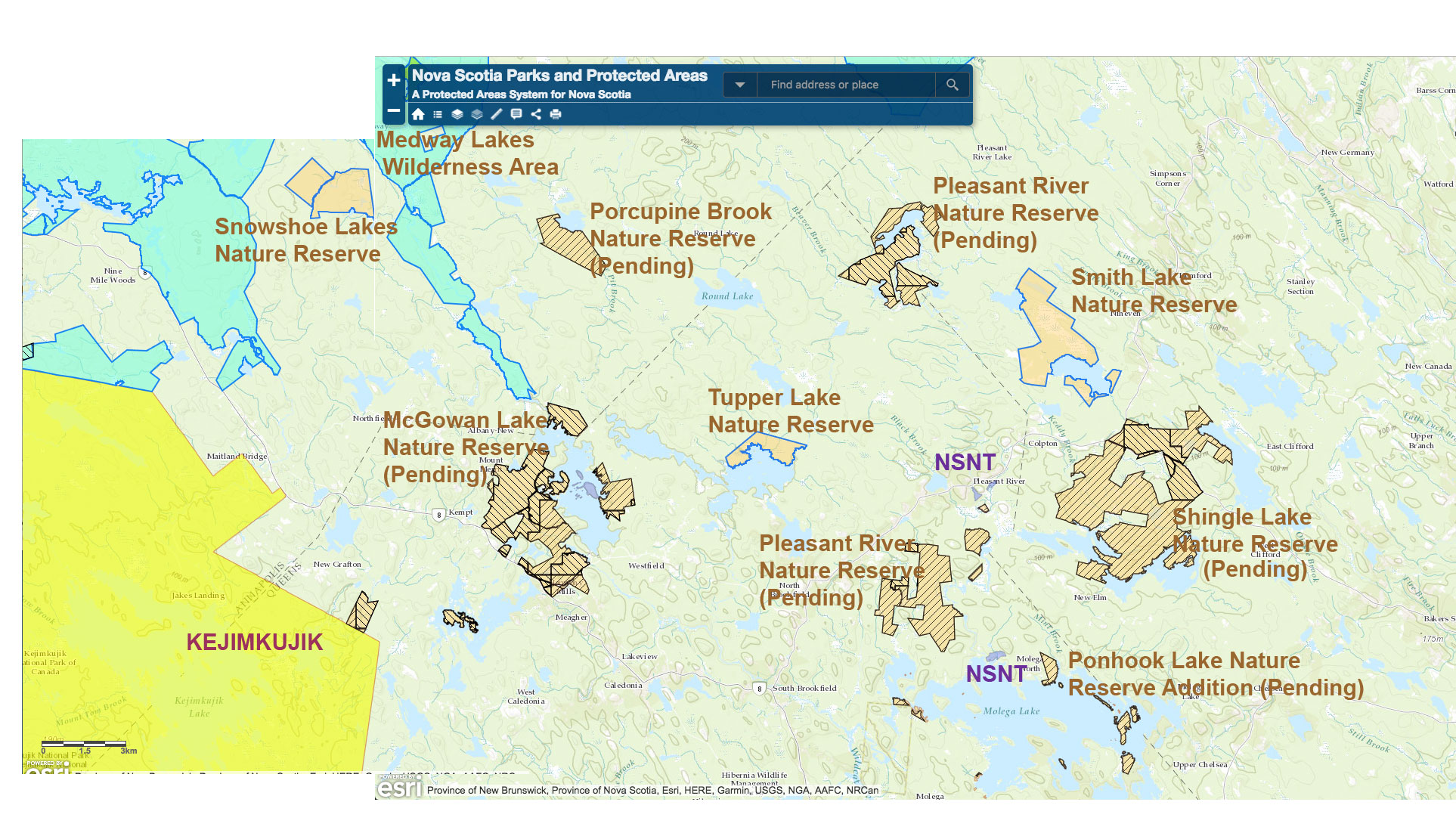
Protected Areas (including Nature Reserves) and pending PAs in the area of Shingle Lake. Not shown: the NSNT Barren Meadow Conservation lands which are “surrounded” by the Shingle Lake Nature Reserve, but have not yet been marked on publicly available maps.
About the pending Shingle Lake Nature Reserve
The Shingle Lake area lies within Ponhook/Molega Landscape, one of six Biodiversity-Rich Landscapes highlighted in the Guidelines for Biodiversity-Rich Landscapes under the Western Crown Lands Conceptual Plan (July 2015). Specifically, provincially rare geological features and globally rare rock heathland ecosystems are cited as key important biodiversity values.
There are lots more.
From the Nova Scotia Environment description for the pending Shingle Lake Nature Reserve (Aug 2013):
Overview
Large forest patch with extensive water frontage and many rare species in a poorly represented landscapeEcological Values
– Habitat for nationally and provincially endangered Blanding’s turtle
– Habitat for nationally and provincially threatened eastern ribbon snake
– Nationally and provincially threatened golden crest
– At least 3 other species of rare coastal plain and arctic/alpine plants
– Mature coniferous forest; extensive wetlands; a species-atrisk hotspotOutdoor Recreation Values
– Canoeing and camping
– Hunting, fishing and trappingForestry Values
– Primarily mature softwood and mixedwood, much of it hard to access
See also:
– Rare Plant Inventory of Lakes in the Ponhook-Molega Lakes Region
by Sean Blaney and David Mazerolle, Atlantic Canada Conservation Data Centre, Botany Program. Report to Nova Scotia Species at Risk Conservation Fund April 7, 2009
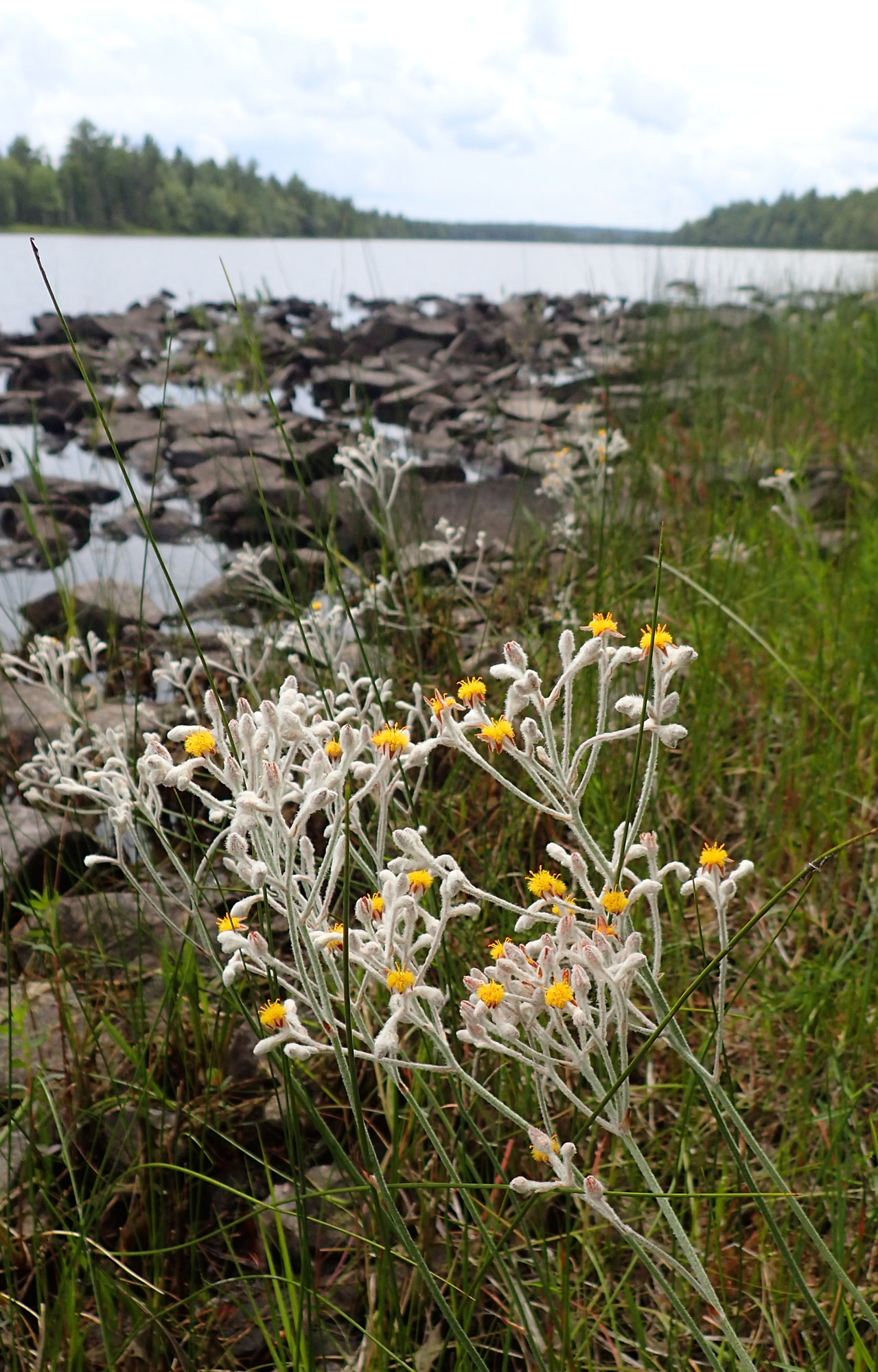
Golden Crest at Shingle Lake, July 2017
– in 2011:
During a plant survey for the Mersey Tobeatic Research Institute, the botanists discovered an extremely rare plant at Shingle Lake Barrens in Nova Scotia – Bluecurls, a member of the mint family.“This hadn’t ever been found before in Nova Scotia . . . and it’s quite rare in Canada,” said Blaney. “So that was an exciting find.” He noted the Bluecurls are now a high-priority candidate for federal evaluation under the species of concern list.
– The Nova Scotia Nature Trust has been active in the Shingle Lake area: view Nova Scotians give Rare Turtles a home: Barren Meadow Sanctuary Protected!
The Barren Meadow property is located in Lunenburg County and is 36 acres in size. Two branches of Barren Meadow Brook pass through the property before connecting with Pleasant River. The brook is deeply cut, and holds water throughout even the driest summers, ensuring that the turtles can easily forage for food along the side of the brook.
Blanding’s Turtles travel great distances away from streams and rivers in search of basking and nesting sites, and this property provides a diversity of habitat types for the turtles. Although mostly forested, the property also includes bogs, the “barrens” that gave the area their name, and unique geological features where bands of rocky outcrops occur in strips throughout the forest. This unusual topography is even visible from an aerial view of the region.
View also Give turtles a home for Christmas, urges Nature Trust
(CH, Nov 24, 2016)
The Barren meadow site is surrounded by the Shingle Lake Nature Reserve and two other NSNT properties lie close by: Deep Brook Bog Conservation Lands & Pleasant River Woodlands Conservation Lands.
– There are a number of provincially established or pending Nature Reserves in the area of the (pending) Shingle Lake Nature Reserve, each protecting special features, habitats and species. (See map for locations.)
Within 3 km of the Shingle Lake Nature Reserve:
– Smith Lake Nature Reserve
– Pleasant River Nature Reserve (pending)
– Ponhook Lake Nature Reserve (addition pending)
Within 10 km:
– Tupper Lake Nature Reserve (protects habitat for a population of eastern ribbon snake)
– Ponhook Lake Nature Reserve
Within 20 km:
– Porcupine Brook Nature Reserve
–McGowan Lake Nature Reserve (pending)
–Eighteen Mile Brook Nature Reserve Addition (pending)
Within 30 km:
and I probably missed some.
Indeed, the whole area is a hotspot of biodiversity, much of it protected in relatively small pieces in the form of Nature Reserves and Nova Scotia Nature Trust properties. This underscores the importance of managing forest on public and private lands outside of the formally protected areas for biodiversity conservation in addition to supplying wood. On this landscape with a lot of multi-aged old forest, that would mean in most cases that most harvesting should involve some type of selection cutting.
Evidently, that is not happening now.
——-
Some Comments on this post:
NH (July 9, 2017): Shingle Lake is of exceptional beauty. It has a suite of nationally rare coastal plain plants including goldencrest and Long’s bulrush and the rarest, blue curls. The scenery is spectacular and reminiscent of Kilarney Provincial Park. How does this proposed cut overlap blue curls (N1 status)?
BT (July 9, 2017): Blue curls is safely inside the bounds of the proposed nature reserve.
The initial cuts where the road was built is mostly forest that has been impacted in the past. Regrowth.Huge signs of impact/modifications to the landscape from former mining activities in the area. No significant barrens habitat. Some nice treed wetlands though as expected for SWNS. The future cuts proposed in the area to the SE on the harvest viewer contain much better habitat and are of a greater concern