
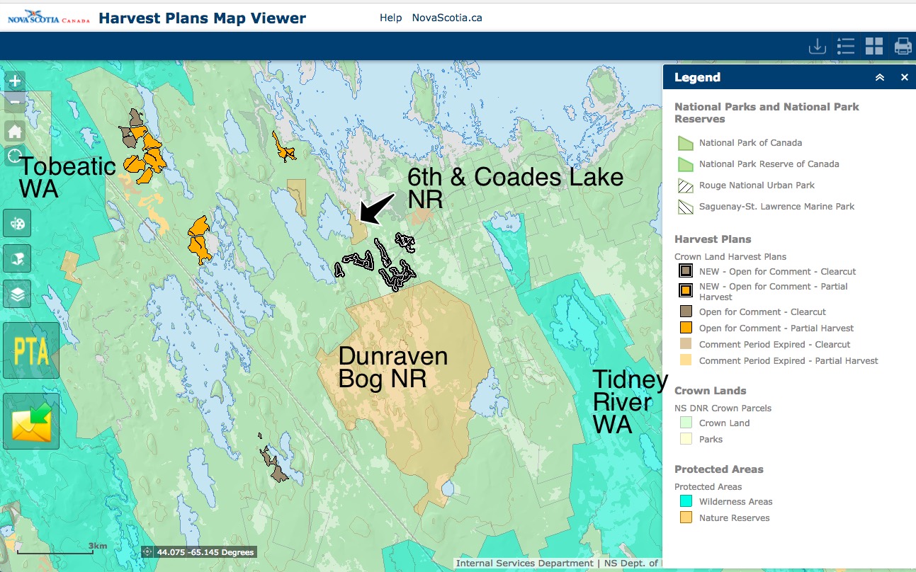
From the Harvest Plan Map Viewer (with names of Protected Areas and Nature Reserves added)
The latest DNR notification (Feb 23, 2018) of newly proposed Crown land harvests are for clearcuts on 457 ha, partial cuts on 39 ha distributed over 4 counties.
The cuts are quickly located on the HPMV. Those in Queens Co. can be seen next to a Nature Reserve, but to get the name of it you need to go to the NS Parks and Protected Areas map.
It is Dunraven Bog, a “Wetland of International Significance under the UN Ramsar Convention on Wetlands”. It is noted that “This nature reserve is located between Tobeatic and Tidney River wilderness areas. This facilitates movement of wildlife, such as endangered mainland moose, between protected areas and across the working forest landscape. Boundaries [of this 3464 hectare area] were simplified through the survey process to enable more efficient, on-going management of the reserve and adjacent lands.”
The cuts cover a significant part of the area between Dunraven Bog and much smaller the Sixth and Coades Lake Nature Reserve, about which there is not much info.
I went to Global Forest Watch to see how much prior cutting there has been in the area since 2001; not much. So this is a first significant foray with 86.6 ha on the block to go all-at-once; who knows what will follow. The big prize in SW Nova Scotia is the abundance of sites that have not been previously clearcut.
As I said, Ho-hum
Ho-hum Meaning in the Cambridge English Dictionary: “an expression used when someone is bored, or when they accept that something unpleasant cannot be stopped from happening”. In this case, it is the latter, but add “yet” after “cannot”.
———-
Two comments on Woods and Waters Nova Scotia (Feb 25, 2018):
DS: Doesn’t look that bad when they display it like this. But take a look at google earth and you soon realize that the black clearcut at the top of Dunraven bog takes in almost all the forest in that area that is on higher ground. The vast majority of hte rest is bog land. This leaves very little habitat in a huge swath of land. Go over to the other cuts and again it does not look like much on this but a quick look on google earth and you soon realize that most of those areas around these cuts have been recently harvested and this will take a great deal of what little mature forest that is left. This can’t keep happening! There is nothing left, when did our forests become a commodity for the use of one group.
JM: i hauled out of dunravin back in 05 or 06,,s&g roy cut in there,,,i’ll be surprised if they get any of their contractors that far off the beaten trail…seems their grumblin now over who’s gettin all the crown blocks closest to the mill,,guess the easiest push over will be up there