
Landscape level planning for biodiversity conservation appears to be lacking in Crown land harvest decisions
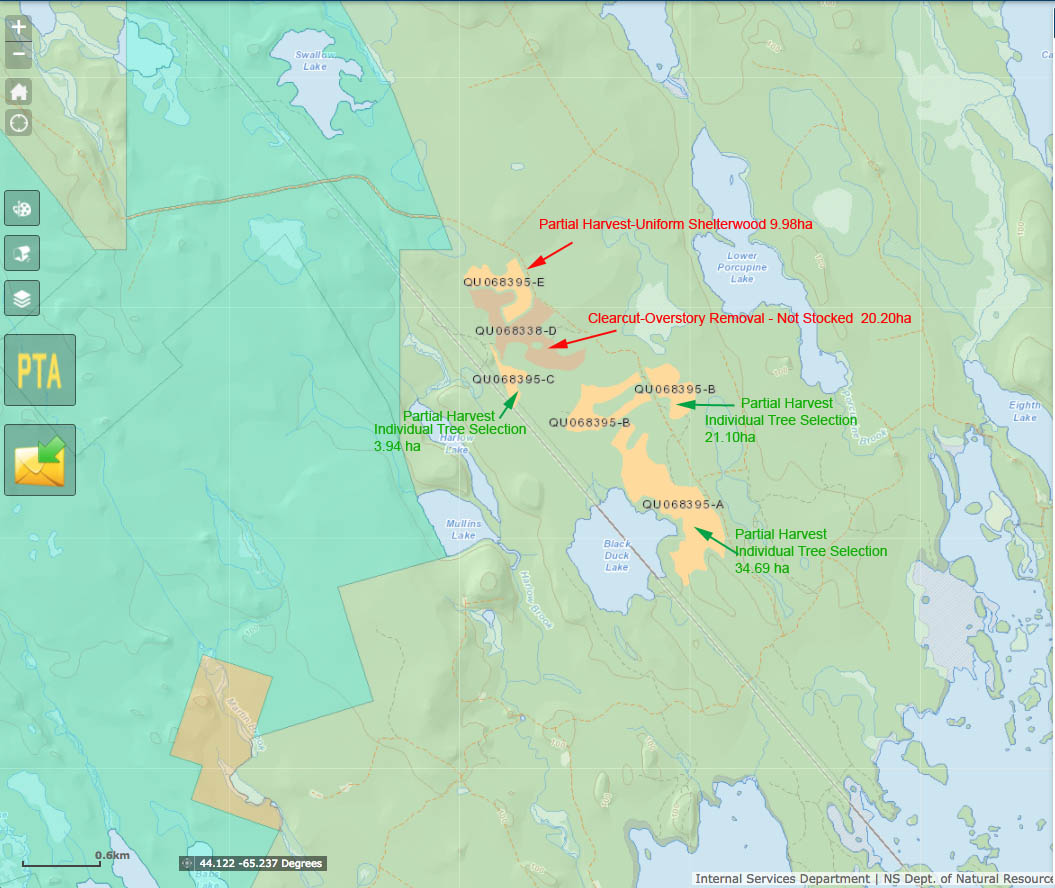
Proposed harvests as shown on Harvest Plan Map Viewer
Click on image for larger version
View Proposed clearcut near pending expansion of protected wilderness area sparks concern by Emma Smith, CBC News Oct 09, 2017.
The proposed cuts were posted July 24, 2017, with comments being accepted up to Sep 2, 2017. “At stake”, reads the CBC story, “is about 20 hectares of forest on the edge of a pending expansion to the Tobeatic Wilderness Area, a haven for endangered woodland moose that stretches into five counties around Kejimkujik National Park.”
Sandra Phinney, “an avid paddler from Canaan, N.S., who regularly explores the wilderness area by canoe” and member of several environmental groups says
…land that falls just outside the protected Tobeatic Wilderness Area — known as the Tobeatic wildlife management area — is too ecologically significant not to protect. “This is the time for the government to take that area and protect it,” she said. “Then it wouldn’t be a matter of whether they’re going to clearcut or not. This would be criminal if they clearcut in there. Absolutely criminal.”
CBC also reports that
Chris Miller of the Canadian Parks and Wilderness Society “wrote a letter to DNR in July asking the department not to approve the proposed harvests because of the potential impact on the Tobeatic’s ecosystem, which includes more than 100 lakes and habitat for several endangered species. Miller says he’s yet to receive a response. He wants the province to have a more informed plan for how it makes decisions on proposed cuts near protected areas. “The concern is that this is happening sort of haphazardly, that there’s no plan in place for it that deals with the particular impacts on the protected areas themselves,” he said.
The CBC contacted DNR Minister Margaret Miller:
“I have looked at the area and know and appreciate, certainly, what that area has,” said Miller on Oct. 3. “The Tobeatic area and the Kejimkujik area comprises almost 500,000 hectares in Nova Scotia that primarily is wilderness area. There is a small area of that land that is, however, available for harvesting purposes.”
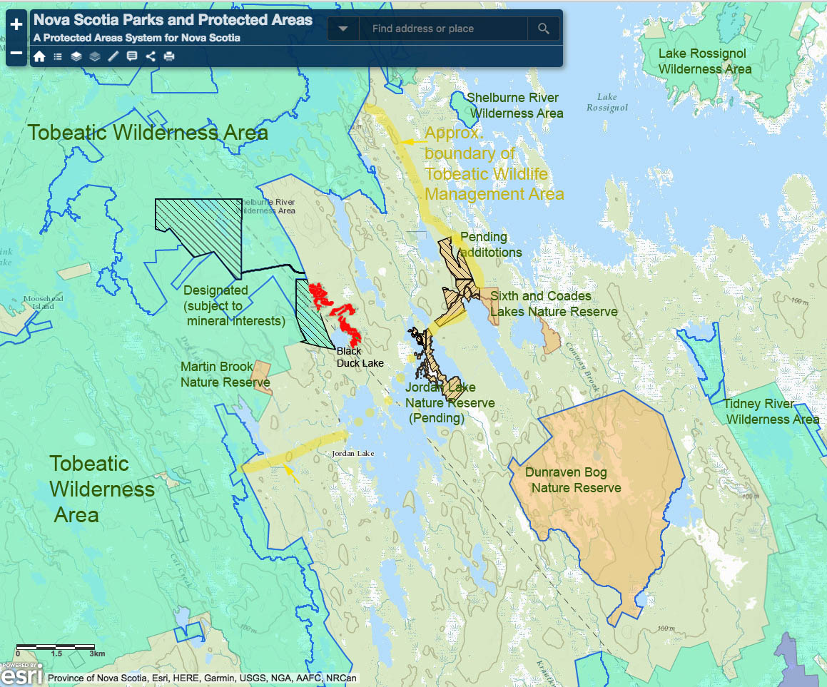
Map showing Protected Areas, Nature Reserves and approx. boundary for the Tobeatic Wildlife Management Area. Map modified from Nova Scotia Parks and Protected Areas Interactive Map; red patches are the proposed cuts.
What the Harvest Plan Map Viewer (HPMV) does not show is the location within the Tobeatic Wildlife Management Area immediately next to a designated addition to the Tobeatic Wilderness Area – see map at left.
Also, the HPMV does not show how much cutting has already occurred in the area, which is substantial, as revealed by The Canadian Forest Service/UBC/Canadian Space Agency Satellite Forest Monitoring map below:
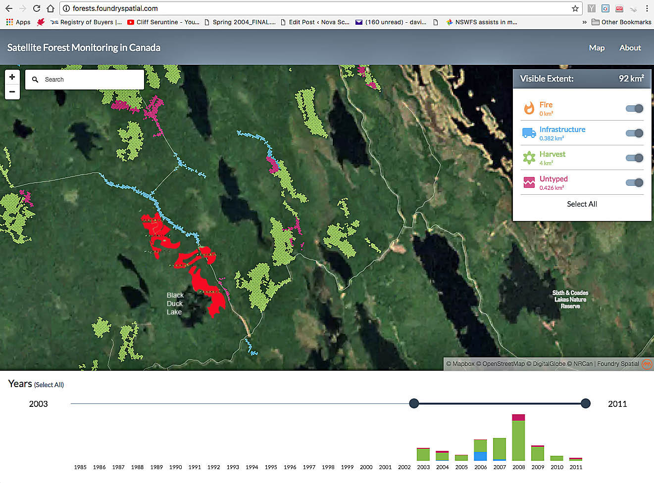
Canadian Forest Service/UBC/Canadian Space Agency Satellite Forest Monitoring map showing harvest 2002-2011 in the Black Duck lake Area. The red patches are the proposed crown land harvests (inserted). Reference to the Global Forest Watch Interactive Map indicates there was not much cutting 2011-2015.
The combination of a location close to several Protected Areas (including Nature Reserves) and previous cutting – not to mention future cutting – should trigger concerns about buffer zones and connectivity and be enough to require selection cutting for any harvest in this area.
In fact, “Partial Harvest – Individual Tree Selection” is proposed for three (total 59.7 ha) of the five separately identified blocks identified for havesting; one additional block of 9.98 ha is identified as “Partial Harvest- Uniform Shelterwood” (classified as a clearcut in the federal system). Only one block is identified as “Clearcut- Overstory Removal” (20.2 ha) which I gather is the second stage in a shelterwood cut, so the newly proposed shelterwood cut will likely go the same way, making 30 ha of clearcut in total.
I am guessing that the rationale for these clearcuts is that the stands are ‘not suitable for selection cuts’ according to NSDNR criteria, but there is another option: NO CUT!
Unfortunately, this story is a repeating one, circumstances being almost identical to those related to clearcuts on Crown land close to the pending Shingle Lake Nature Reserve, not far away. Both underscore the apparent lack of landscape level planning for biodiversity conservation in Crown land harvest decisions.
LINKS
Other recent cases of cutting near protected areas:
Show us the science behind clearcuts on Crown land close to the pending Shingle Lake Nature Reserve, Nova Scotia Post, Aug 9, 2017
Clearcut Nova Scotia continued..4July2017 & highgrading at the landscape level Post, July 6, 2017 – French River Wilderness Area
Clearcut Nova Scotia, continued..12June 2017 Post, June 17, 2017 – Margaree River Watershed Protected Area and the Ruiss Noir Protected Area.
CBC Mainstreet on clearcutting near Gully Lake Wilderness Area Post, May 25, 2017
More cutting near Nova Scotia Protected Areas…now Loon Lake Nature Reserve
Posted on May 24, 2017
Tobeatic Management Plan
NS Environment. From the plan, page 20: “Management activities will be reported at an annual workshop and public information session, hosted by Nova Scotia Environment and Labour. The purpose of this annual event is to review activities, advise of anticipated projects, and identify emerging priority actions.” I wonder when this last happened.