
Questions begging for answers
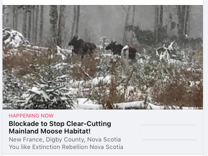 UPDATE Oct 22, 2020
“Extinction Rebellion Forest Protectors are camped out NOW, and are committed to stopping this clear cut.” Posted on Annapolis Royal & Area – Environment & Ecology late yesterday
Oct 23: Protesters block logging road over mainland moose protections (audio)
CBC Info AM
UPDATE Oct 20, a.m. related to comments about Irving in SW Nova Scotia, wood going to NB: I just had a phone call from Irving; an Irving rep said that they have no operations in Digby Co., and do not ship logs to N.B. She followed up with an e-mail which explains more precisely why she said the “references to Irving are not accurate”. In her post on a public Facebook group (which I copied verbatim), NN cited the info as “Local information also has it..” and commented “Perhaps it’s not true that Irving is taking the wood from Crown land in Southwest Nova straight to New Brunswick”, so I was Ok with citing it here without verifying it separately; in turn I appreciate the clarification from Irving, which came without agitation.
UPDATE Oct 20, a.m. (related to section below on “Cutting in Moose Habitat”):
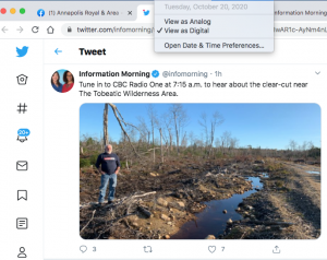
On CBC Info AM Today (Oct 18, 2020). Click on image for link to Info AM Twitter Page. Listen to archived interview
Also view
– “Richard Amero shows the moose track by the side of a logging road on crown land near the Tobeatic Wilderness Area.”
– “Picture of moose cow and calf taken by Richard Amero in Nov 2018, in this same area.”
– “Here’s a photo from Oct 12, 2020. Taken in the Tobeatic Wilderness Area! It’s been reported.”
—————-
ORIGINAL POST
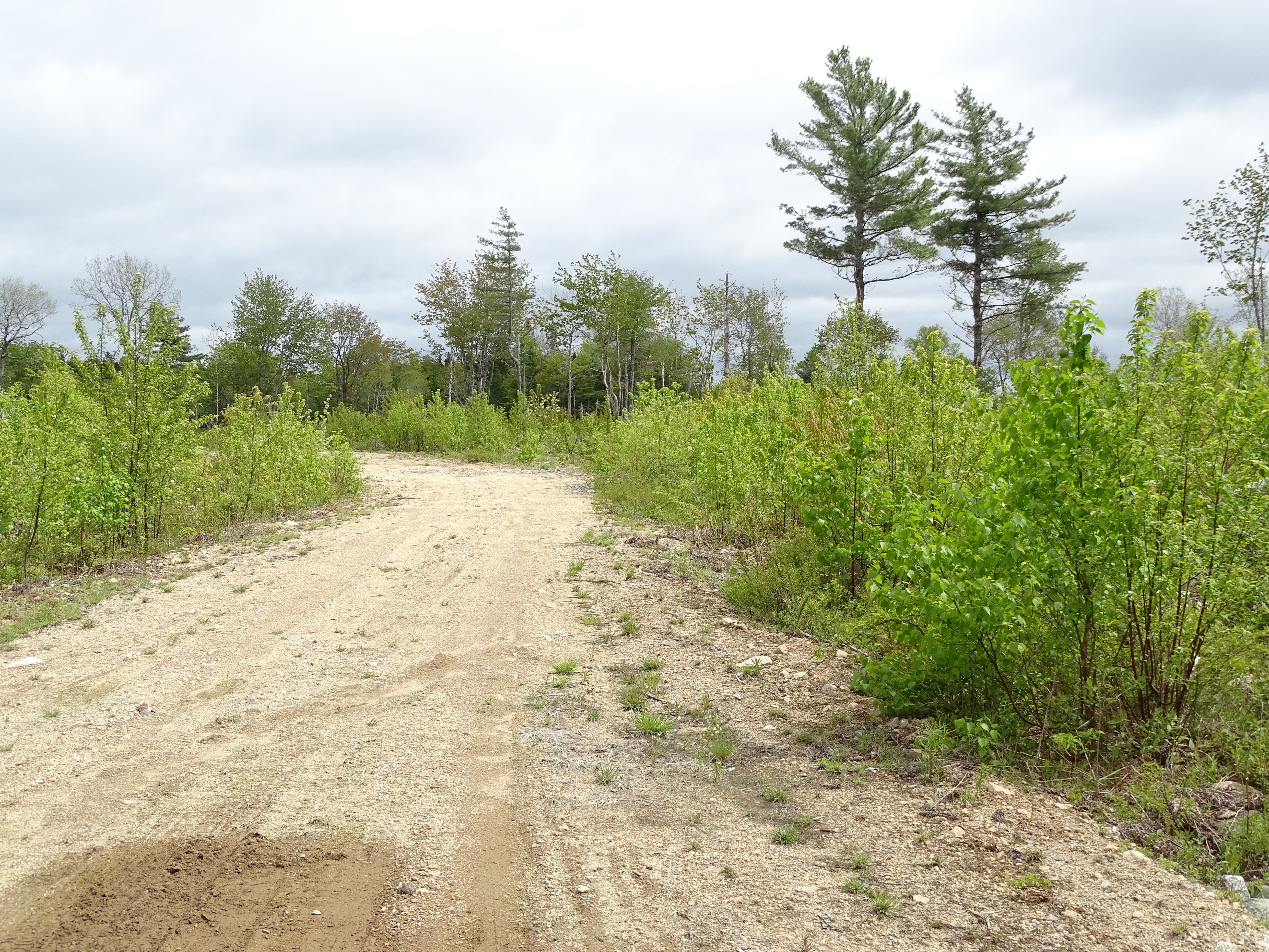
A common scene in Annapolis Co. (Photo in 2017).
Annapolis County shoulders a disproportionate share of the logging on Crown lands in southwest NS, with few of the benefits accruing to WestFor’s 13 member companies, none of them based in Annapolis Co.*
_______
*I went to the WestFor website to check the listing of company members and found a glossy new feel-good website but that it no longer provides that info. So I went to the web archive to check it – the item listing Members is for May 5, 2017.
Annapolis County Council has repeatedly tried to gain more say on logging within the County, requesting exclusion from Westfor logging, proposing that they manage an old forest block as a cloud forest with thinnings to be used for local heating, requesting an “Indefinite moratorium on glyphosate spraying for the entire county”, all to no avail. (In Ontario municipalities can specify cutting practices.)
Annapolis Co. folks have taken up the mantle, reviewing newly proposed Crown land harvests, highlighting issues related to old growth and migratory birds, protesting spraying and even buying up private land about to be clearcut. They have also actively supported local, sustainable logging.
A lot of the discussion of these issues has occurred on the public Facebook Group Annapolis Royal & Area – Environment & Ecology – I often refer to it as the “Annapolis Ecology Group” for short – created on October 29, 2018 by naturalist and Annapolis resident Bev Wigney.
The Annapolis Ecology Group has encouraged folks to visit proposed Crown land harvest sites that are not well known locally, and to post photo observations on iNaturalist. Their first such foray, to the The Corbett Lake Old Hardwood Forest, proved to be quite a story, revealing first that the site had been posted by L&F on their Harvest Plan Map Viewer by mistake, and second that the site has trees of Old Growth age and is a hotspot for biodiversity. Regardless, Minister Rankin drew a line in the sand on their and subsequently the County’s efforts to protect The Corbett Lake Old Hardwood Forest.
Two items have come up in discussions on the Annapolis Ecology Group recently that illustrate the growing frustration with the log-as-usual on Crown lands while we wait, seemingly endlessly, for L&F to figure out how to implement the Lahey Recommendations, and then to actually follow them.
The Godfrey Lake Parcels
This past summer BW became concerned about the intensity of proposed cutting in the Godfrey Lake area just south of West Dalhousie in Annapolis Co. and sent off a comment on one of the blocks (#AP068719C) to Forestry Maps.
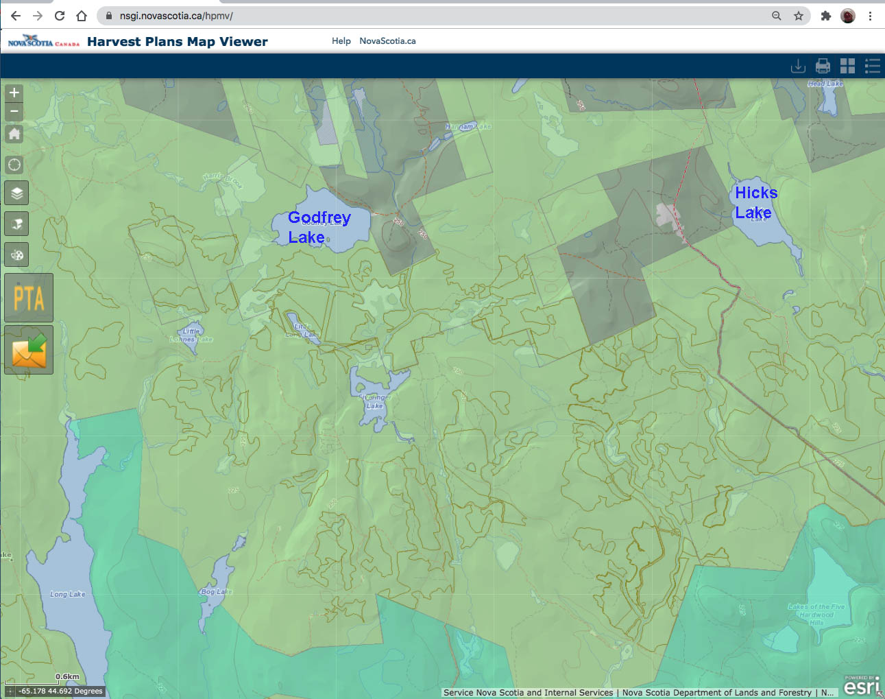
There are a lotta Approved Harvests southwest, south and southeast of Godfrey Lake. And there was more clearcutting to the east of Godfery Lake before these ones.The faint lines show harvests already approved over last 3-4 years, some already cut, as shown in the archive layer of the Harvest Plan Map Viewer. Click on image for larger version. View more maps.
BW noted that
“Under the Southwest Nova Scotia Habitat Conservation Strategy, an area that is encompassed by these parcels being referred to as “Godfrey Lake”, have been given a HIGH ranking in the Conservation Value Index (CVI) and a VERY HIGH ranking under Priority Habitat Composite (PHC). Considering that we are STILL WAITING to find out which forests will be designated as ECOLOGICAL MATRIX FORESTS under the Lahey Triad plan, why are you even considering doing any chopping up of an area which has a high CVI ranking?” Read more and view some maps under Godfrey Lake Parcels
Is some of the progress semantic? Top figure from DNR: An operational clearcut definition (2012), bottom from L&F Forestry Maps, 2019
L&F stopped using the term clearcut in 2019.
Click on image for larger version
In reply, Forestry Maps defended the intensity of harvesting generally, and came up with a new definition of clearcutting – a Variable Retention cut with 20% or less retention – which allows L&F to claim that clearcutting in NS has been reduced by 27% since the implementation of the Interim Retention Guide (Dec 2018).
The line between whats a clearcut and what’s not for Variable Retention harvests is not well defined, but one study by the federal and university researchers found that the pattern of cutting has a big influence on how it affects nitrogen cycling and that “High levels of retention (> 70%) were required to maintain uncut stand N-cycling characteristics.” So the question can be asked:
On what basis did L&F choose 20% VR as the cut off between clearcuts and non-clearcuts, noting that in the correspondence with BW there is no reference to how trees are removed and how they are retained, and no reference to any supporting documents?
I might also ask,
How does this new definition of a clearcut relate to the still-in-place (apparently) 2012 definition: “A clearcut is a forest harvest where less than 60% of the area is sufficiently occupied with trees taller than 1.3 metres”
As far as I can figure out, the cutoff line by that definition would be 60% retention, not 20%. But I could be mistaken. I will ask L&F for a clarification.
At least in the response to BW, L&F finally acknowledged that there is still some clearcutting going on- they stopped using the descriptor ‘clearcut’ shortly after they introduced their Interim Retention Guide – see Variable Retention on this website.
Another issue that BW raised: many ‘little cuts”:
What’s with all of these little cuts between already devastated forests that are now gone, like the parcels up for approval around Paradise Lake? Now you seem to be posting tons of these small stands – on one of the last Forestry Maps listings, about 1/3 of all the parcels were just small parcels — many just 2 ha. What are these? Why weren’t they cut down earlier? Were they left standing as wildlife shelter areas so that you COULD go ahead and cut down everything around them?
I went out and looked at some of them. They aren’t hard to find as they are the LAST and ONLY patches of forest left standing in between the *already devastated* parcels where there is NOTHING anymore. Where do you expect the wildlife to “move to” next when you cut down the very last parcels between the already clearcut areas?
Good Questions.
Cutting in Moose Habitat
Yesterday Annapolis resident NN posed some questions on the Annapolis Ecology group about logging on Crown lands lying between the Tobeatic Wilderness to the east and the Silver River Wilderness Area to the west:
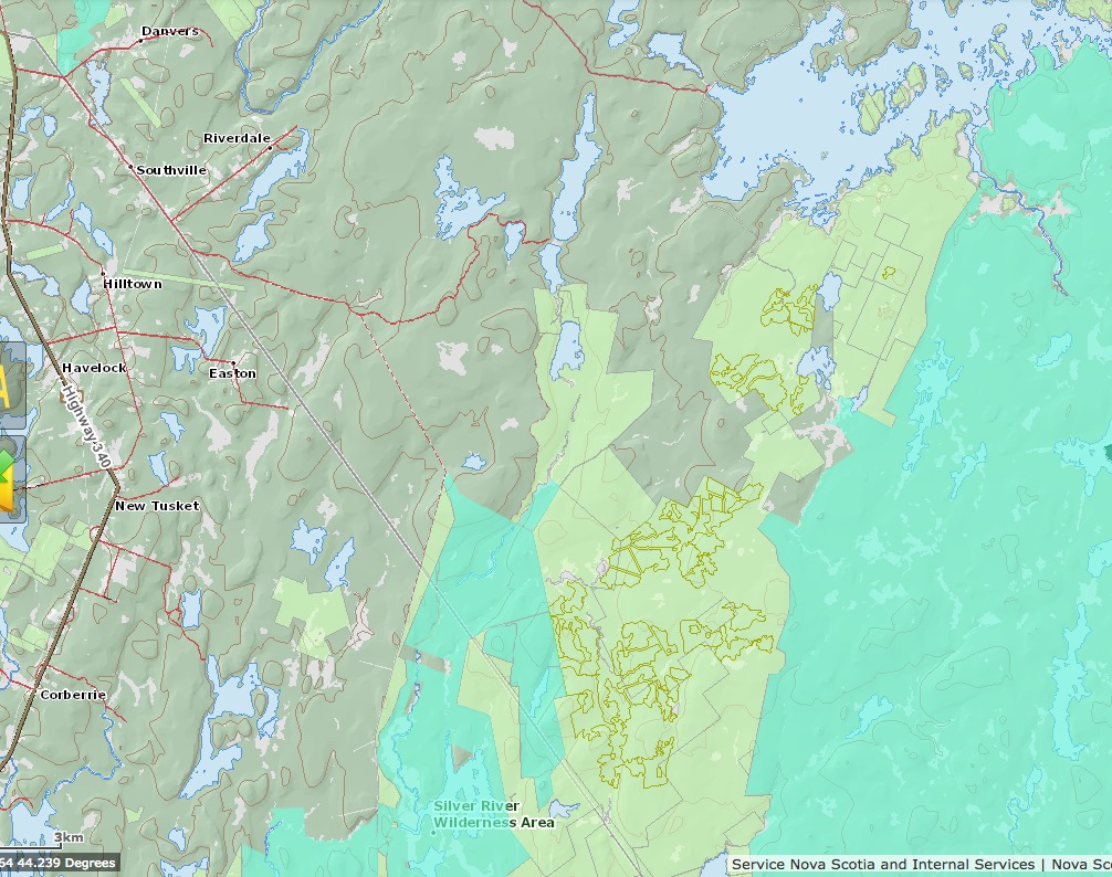
From NN’s post, reproduced on NSFN:
The pale green patches on this map are Crown Land. The grey-green is private land. The blue-green is the Tobeatic Wilderness to the east and the Silver River Wilderness Area to the west. The big lake to the north is Fourth Lake. This Crown Land is known habitat for the endangered Mainland Moose. Recently posted photographs of a Moose cow and her calf were taken in this area. The Nova Scotia Supreme Court ruled this summer that our provincial government has failed in its obligation to protect endangered species. Meanwhile, the federal government has committed to protecting 25% of Canada’s lands and oceans by 2025 and 30% by 2030.
So why not protect this whole area of Crown land?
See those olive lines outlining clusters of irregular shaped patches on the Crown land? Those are parcels that have been approved for cutting by the Department of Lands and Forestry in the last 4 years. Almost all the cuts shown are clearcuts (by various names). Some have already happened. Many have not, but they are about to. WestFor, the consortium that has the contract to harvest on our Crown land, included Northern Pulp. You might have thought the closure of Northern Pulp would give our over-harvested woods a break but no, the province is allowing Irving to cut Northern Pulp’s allocation.
So the government is encouraging clearcutting of this Crown land even though it is known moose habitat? There must be lots of jobs for Nova Scotians then.
BUT, notes NN,
According to local information in Digby County, Irving is bringing in 20-22 crews from New Brunswick and Quebec to clearcut Crown land all across the province. No jobs there. Are the workers coming in from Quebec quarantining for 14 days?
Local information also has it that the wood Irving cuts from our Crown lands is hauled straight to the ferry in Digby. Trucks unhitch their trailers and pick up empty ones. Meanwhile the full trailers are hitched up to trucks from New Brunswick and taken across the Bay. The trucks don’t even fill up with fuel in Nova Scotia.
Perhaps it’s not true that Irving is taking the wood from Crown land in Southwest Nova straight to New Brunswick. After all, it would be illegal to haul Hemlock out of the five county area, and saw logs cut by members of the Westfor consortium are supposed to go to Nova Scotia sawmills. Still we have to ask why?
Why is this Mainland Moose habitat not a top priority for protection? Why, when the single best and cheapest way to address the climate and ecological emergency is to keep natural forests standing, is our government encouraging the destruction of these forests?
More good questions.
We could use some answers.