
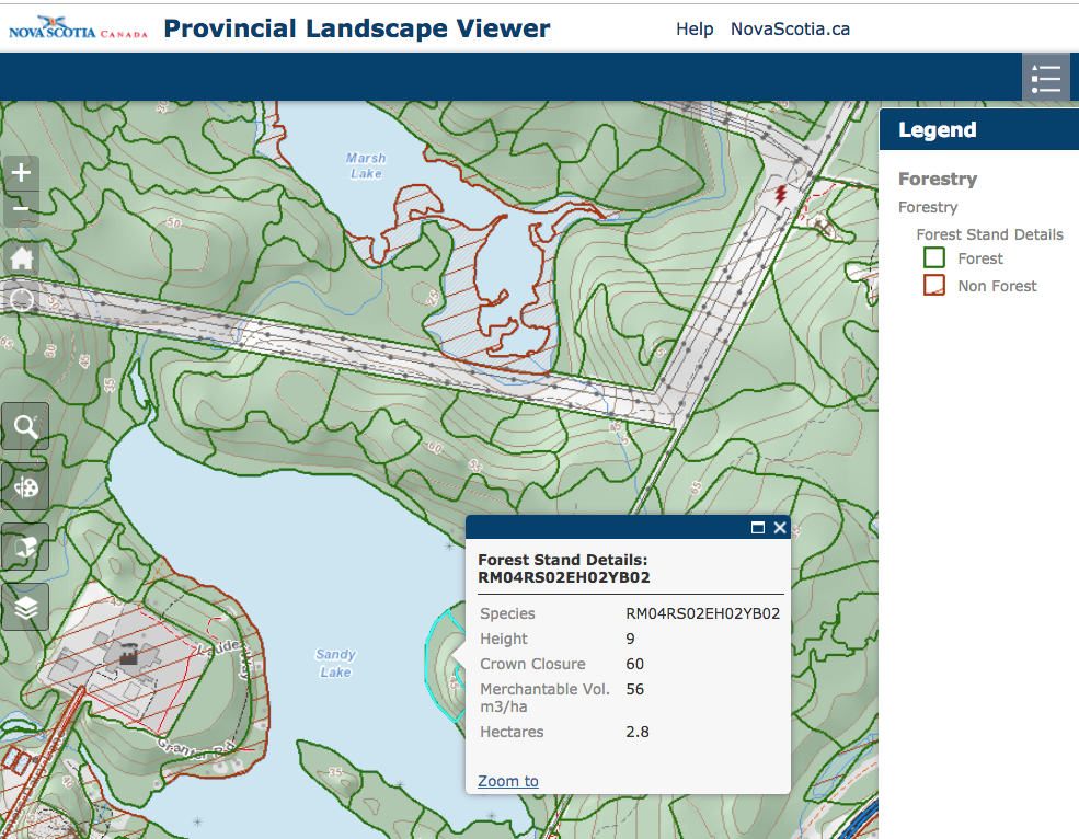
Forest Polygons in the Forest Stand Details layer on the Provincial Landscape Viewer. The box comes up when you click on an individual polygon and gives info stored in that particular layer.
An Old Growth stand in Nova Scotia does not necessarily a polygon make
There have been several instances recently of citizens recognizing that harvest plans posted on the HPMV include some Old Growth (e.g., Post Dec 18, 2019) this in spite of the lessons NSDNR said they learned earlier this year following Danny George’s highlighting of cuts of significant stands of Old Growth on FSC Certified Crown land in eastern Bova Scotia.
A constructive to and fro with L&F Minister Rankin on Social Media on the topic led to some acknowledgment that what’s generally being missed are patches of Old Growth smaller than whole Forest Polygons. The Minister promised some follow-up.
I have copied some of the discussion below.
EXTRACTS FROM A DISCUSSION initiated by Ken Burrows on The Healthy Forest Coalition. (Click on that link or here to go to view the full discussion.)
Some highlighting added.
January 15 at 11:38 PM
Ken Burrows shared a link.
https://data.novascotia.ca/Lands-Forests-and-Wildlife/Old-Forest-2006/wanf-acts
Are there any technical people here who can explain this map?

I think it ID’s Old Growth and potential Old Growth sites, however most of the polygons are in protected areas, the rest of the map when you take out the protected areas show very little potential Old Growth sites..
How can you develop more Old Growth if you are harvesting most of the “Mature ” wood and not allowing significant areas to become Old Growth eventually?
Am I looking at the wrong Map?
DGP (nsforestnotes): No, you are looking at the right map. That’s what they did, pick actual or potential OG sites within already protected areas as possible so there would be minimal impact on wood supply. The OF sites are also in the Provincial Landscape Viewer; I compiled a whole province view at http://nsforestnotes.ca/keeping-track/compiled-maps/.
BW: Here’s an example to show you how LITTLE that Lands and Forests CARE about their own data. I just made this screen grab of the Corbett-Dalhousie Lake peninsula using the Provincial Landscape Viewer (PLV).
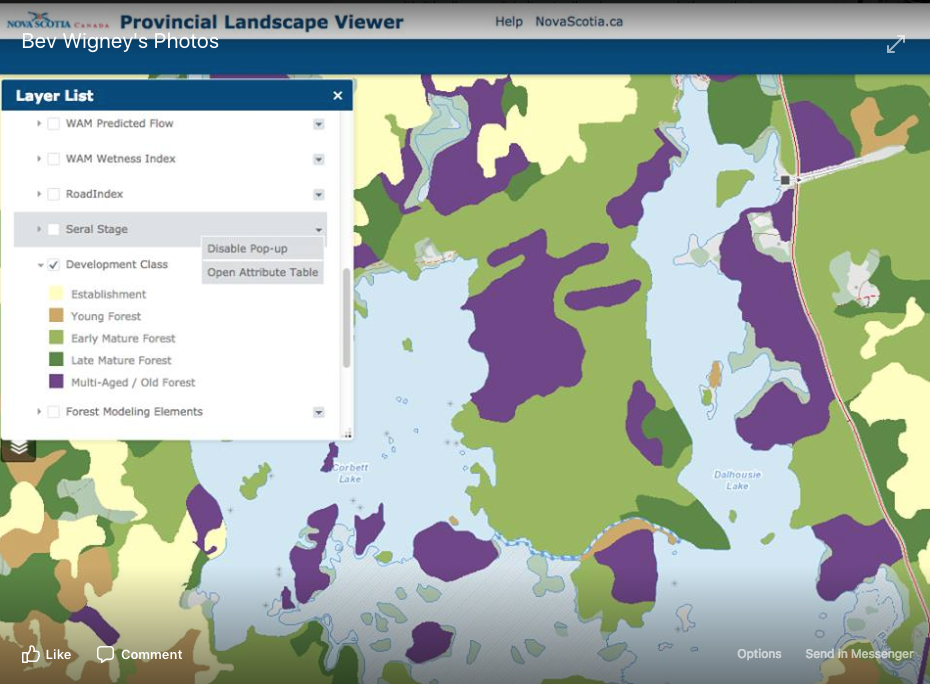
Take note of the dark purple area on the peninsula. Purple is “Multi-Aged/Old Forest. However, it is being harvested — has already begun — and will continue this spring. It is being given a Uniform Shelterwood Harvest – so they have begun by cutting out the middle aged trees – many of which were Yellow Birch. They also cut down some “old growth” trees that were hollow in the center and are now lying on the ground in a pile. I photographed them – they were pretty iced over, but even at that, you could see they probably had well over 100 years of growth rings and that isn’t even counting the hole in the middle which would have the denser growth rings. There is a LOT of young Balsam in spots in that forest. Without the big hardwoods to shade that stand, those are going to grow. Is that what they want? To turn a multi-age “OLD FOREST” stand — a terrific ecological stand — into a big patch of Balsam fir that have a comparatively short lifespan. I am so disgusted that LAF doesn’t even follow its own guidelines. EDIT: Here Mr. Iain Rankin – if you actually read posts on this forum — This is what you are allowing to take place in the Corbett-Dalhouse Lake forest … We are going to lose one of the ONLY OLD FOREST stands in this part of the Annapolis County – in a scenic area — on a canoe route in our Annapolis Country recreation department’s own publication of canoe routes. All because nobody bothered to do proper ground-truthing of this stand. Sorry to say, but this is an example of incompetence at its worst.
ML: It doesn’t take long to see how inadequate the data is as I could put at least 10 stands that I know are Old Growth from performing scoring personally. A big part of the problem is that LAF has not dedicated the required effort to ensure that Old Growth forests are not being harvested. There were two proposed harvest sites of untouched (never having been harvested) stands in December alone. The main reason that these sites get cancelled, if that happens at all, is because of members of the public going out and identifying them themselves.
DGP: It’s very sad to think of how many are going down (and how many have gone down since the Natural Resources Strategy recommendations (2011) when it should have stopped. By the time they get around to it, it could be 10 years later. Any wonder that people are very upset with ‘we need time to adjust, again… the wildlife can move to another location’.
Iain Rankin: The process of selection harvesting leaves long lived, shade tolerant species to mix in with the remaining and creates more mixed age forest. The purple section is “multi-age/old forest” there may be some old trees, but not old forest based on the department’s policy. My direction on this stand, based on public concern about a follow-up clear-cut, is that will not be permitted.
BW to Iain Rankin But will the rest of the stand north of the first part that was harvested in the autumn be given that treatment this spring — as a “first cut”. If so, I don’t think it will be giving proper respect to the ecology of this forest...I should add that I am not against harvests.. I understand the use of selective harvests. However, I would not call the first strips of harvest at the south part of the forest selective. This forest could probably be harvested in a low impact selective way, removing some good timber without damaging the basic matrix — but I don’t think that is what is intended — based on how the hardwood part of the forest work has begun.
DGP to Iain Rankin Thank you for joining the conversation Minister Rankin. Re “not old forest based on the department’s policy” My understanding is that it could overlap with the identified Old Forest policy stands (units, clusters, polygons); regardless most of those Old Forest policy stands are not Old Growth but rather potential Old Growth. In fact, you could expect quite a few patches of Old Growth within the purple sections, but they are not likely in most cases to fill a whole polygon, which is what is required for a stand to be formally classified as Old Growth under the DNR protocol and what people are mostly seeing on the ground are patches smaller than polygons; regardless, the patches should be conserved because they are nuclei. Thus I have suggested* that the PTA includes a set of questions related to possible presence of Old Growth in patches smaller than whole polygons to be answered in text form by the observer, e.g.:
– Give species and diameters for the 5 largest trees for each sampling point
– Did you observe any patches (versus whole stands) either in the sample areas or outside of them that you might describe as Old Growth
– Give coordinates, and approximate size of the patches
– What features of Old Growth were present (check list provided)
– Provide some photos
*http://nsforestnotes.ca/keeping-track/hpmv/
Iain Rankin to DGP: fair comments on the smaller than polygon potential ‘old growth’. I will discuss with staff and have them reach out to the licence holder about their plans for harvesting and retention areas.
BW to Iain Rankin – Thank you following up on our concerns.
DGP to Iain Rankin Thank you
———————–
REFLECTIONS ON POSITIVE INTERACTIONS WITH THE MINISTER
FROM A FOLLOWUP DISCUSSION initiated by Bev Wigney on Annapolis Royal & Area – Environment & Ecology, jan 17, 2019:
BW: NEWS!! NEWS!! NEWS!!
CORBETT-DALHOUSIE LAKE FOREST
While this isn’t what I would call cause for rejoicing, it is a somewhat hopeful development. Yesterday, after I posted the screen grab image of Corbett Forest’s “multi-age/Old forest” purple coded patch — along with my comments on Healthy Forest Coalition (I reposted it here yesterday morning — so look back to see my comment) — more discussion ensued last evening on Healthy Forest Coalition’s page. To my surprise, Minister of Lands and Forests, Iain Rankin, posted a couple of comments regarding our Corbett-Dalhousie Lake Forest…
CS: Bravo!
Bev Wigney Cheryl Stone — Well, not quite “bravo!” just yet as they still want to do the FIRST STAGE of the the Uniform Shelterwood harvest — as has been started at the south part of the parcel — and I believe that to be unacceptable for this type of forest — I can see where a “selective” harvest could be okay — but cutting strips through the forest does not seem acceptable to me — Anyhow, at least it won’t get the SECOND STAGE which is, in effect, the completion of a CLEAR CUT. We’ll have to see where things go from here.
Adele MacDonald Actually, I think Cheryl’s bravo should stand 🙂 We have to remember to take the small wins with the big wins – when they come. The Minister responded – he’s engaging with people critical of the departments’ approach – to me, that is a HUGE small win …See More
DGP TO AM: Agreed. We actually had a short, impromptu (more or less), fully transparent meeting with the Minister.. also emissions-free and achieved something. Now if only Forest Nova Scotia and some others would do more of their dealings with such transparency (and allowing others to participate), we could really get somewhere. A huge kudo to Minister Iain Rankin for his part in it all.
BW TO DGP — Totally agree. Kudos to Minister Iain Rankin for “meeting” with us. These kinds of discussions can actually be productive – and help to get past the frustration that many have been feeling.
SH: That put a spark of light in my belly…it’s rather beautiful.
SS: This is a slight light at the far end of the tunnel. We need to keep speaking
What is a “Forest Polygon”?
My definition (please improve): A polygon in GIS (Geographic Information Systems) is an area delineated on a digital map according to certain features or properties of the area and is used to store and provide access to related information. A “forest polygon” in the Nova Scotia mapping systems corresponds to a distinct forest stand that differs from distinct neighbouring stands, as inferred from “stereoscopic interpretation of true colour aerial photographs”.
Forest Polygons in the Forest Stand Details layer on the Provincial Landscape Viewer. The box comes up when you click on an individual polygon and gives info stored in that particular layer.
From DNR › Forestry › Forestry Program Areas › Forest Inventory Photo Interpretation:
“The Nova Scotia Department of Natural Resources (NSDNR) obtains aerial photos for 1/10 of the province each year. Using paired photographs, the interpreters can see in three dimensions. The interpreters use this perspective to delineate homogeneous stands of trees [the polygons] and interpret crown closure, stand height, species and land capability (an estimate of productivity). From these interpreted attributes, estimates such as stand basal area and volume are computed and form the basis of the forestry layer stored in NSDNR’s GIS database.
The NSDNR Photo Interpretation Specifications provides more details:
Every hectare of land and water in the province is viewed on aerial photography and classified into one or
more of 21 forest types or 18 non-forest types. For each forest stand or polygon tree species, average codominant tree height of the stand, tree crown closure and site capability to grow forests are recorded. These four attributes are used to derive additional individual stand attributes described in this document. Nonforested areas are also classified into a series of categories described in this document.From 1987 to 1996 the entire province was interpreted and the first version of the digital resources data base was created. The current photo interpretation process is a review and update of the original data base. The update process is designed to cover the province on a continuous repeat cycle of ten years.