
Issues with maps, databases and penetrating NSDNR’s “Specialized Skills Firewall”
UPDATE Feb 23, 2017: View Op-ed by Bob Bancroft Public forests should not be private resource (CH Feb 21, 2017), in which he responds to Marcus Zwicker’s Op-ed, cited below.
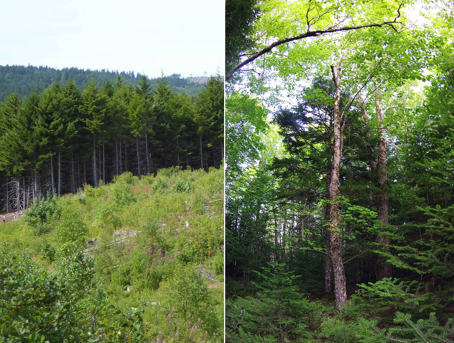
Choices: two woodlots, two approaches to forest management in Nova Scotia. Which one would our grandchildren’s grandchildren want us to choose?
Gary L. Saunders’ Managing forests is not that easy (CH Feb 11, 2017) is a bit of mixed or nuanced message on the for-or-‘agin-clearcutting front, as was a previous op-ed by GLS. “Every blowdown, every lightning-fired site, every pest-killed woodland tract is a kind of clear-cut. And in our moist Maritime climate, most will soon reseed to those softwood species so beloved of pulp company CEOs and biomass converts” he writes. As in his previous Op-ed, Previous op-ed Saunders is very clear that he doesn’t approve of biomass harvesting.
Saunders is quite complementary about Crossland (“At least Donna Crossland knows her forest ecology”) and her use of Global Forest Watch images to illustrate the intensity of clearcutting in Nova Scotia. Not so for Mark Zwicker in All tree loss isn’t due to clear-cutting (CH Feb 11, 2017).
Zwicker is identified as “a registered professional forester. He lives in Bridgewater”. Either Zwicker or the CH forgot to mention that he is also, according to his Linkedin profile, the “General Manager of WestFor Management Inc.”, the consortium of mill owners that is essentially being given the keys to the Western Crown Lands.
As part of the department’s [NSDNR] innovative approach to fibre allocations, the departent has engaged a group of forest businesses to come together to manage the western Crown lands. The consortium was incorporated in 2015 as WestFor, which will jointly hold one western Crown harvesting license. A Forest utilization License Agreement (FULA) negotiation began with WestFor in July 2015 and is expected to be completed by December 2016.
SOURCE:A new Approach, Appendix 1 in The path We Share. A Natural Resources Strategy for Nova Scotia 2011-2020 Five Year Progress Report (Aug. 2016)
A reader might conclude from Zwicker’s piece that Crossland was trying to confuse readers with her use of the term “forest loss” and made some pretty grievous errors in her use of the GFW images. I didn’t, and here are some of the reasons why.
The semantics
Mr. Zwicker equates Crossland’s “Forest loss” with deforestation, and goes on to explain that harvesting trees does not cause deforestation—which clearly was not what Crossland was describing, nor what is described on the Global Forest Watch (GFW) Maps she referenced where the term is “Tree Cover Loss”, not Forest Loss. To be consistent, Crossland should probably have used the term “Tree Cover Loss”, rather than forest loss, but then Zwicker himself does the same “If you look closely at the GFW data, it explains that forest loss…”
Really, the problematical term is “loss”, not “tree” or “forest”. “Loss” implies some kind of permanency, so could be construed as misleading (as Zwicker argues), but this use of the term (loss) originated with GFW, not Ms. Crossland.
Interestingly, the Feds recently hatched an interactive Satellite Forest Monitoring Map and avoided some of these semantic issues by using the term “Forest Change”, breaking it down into several components one of which is Harvesting. (Others: Fire, Infrastructure and Untyped).
A Glaring Omission
The GFW map that Crossland consulted presents both “Tree Cover Loss” and “Tree Cover Gain” (depending on how you query it). Zwicker is particularly critical of Crossland for citing Tree Cover Loss data but not Tree Cover Gain data which he notes was “about one third of the size of the area experiencing loss”. This is a “glaring omission he says, implying that Crossland was deliberately deceptive.
In my view, it is quite the reverse because most of the Tree Cover Gain is in areas harvested before the 2001-2014 interval covered by GFW for Nova Scotia (i.e. it is not growth in undisturbed forest). So in this sense Crossland was being conservative in her representation of the total area harvested.
Even GFW may have underestimated the Tree Cover Loss. I had previously used the GFW interactive map to examine a forested area which I know well, and its history. I found that it assigned land to the “Tree Cover Gain” category that I knew had been clearcut in 2004; I concluded that the GFW maps are not very accurate in assigning changes to one category or the other for the older part of the interval it represents (2001-2014), probably because of poorer satellite imagery in the earlier part of that interval.
The Western Crown lands
Zwicker cites stats for the Western Crown Lands saying that “In 2016, harvesting operations were conducted on about 2600 hectares of western Crown land out of the 550000 outside of Parks and Protected areas. This is only 0.5% of the total.”
He fails to mention that Westfor is just getting geared up to cut those lands… and that those lands are some of the last remaining Crown lands that have not been intensively exploited in recent years, not to mention his own position with Westfor.
Please Mr. Zwicker, tell us what your plans are for the next 10 years!
Zwicker also says that “Of those operations, about half were divided into various partial harvest operations that promote natural regrowth”. He does not say that most of the Partial Harvests were conducted in the context of even-aged management, which the National Forestry Database classifies as clearcuts!
What percentage, we could ask consisted of selection harvests designed to maintained a mixed, multi-aged Acadian forest? We won’t know unless he or NSDNR decide to tell us, but my guess based on cutting on other Crown lands in 2014, is that the figure is less than 10% of all cuts, a figure that is NOT consistent with NSDNR commitments to “ensure that all harvest treatments are aligned with the nature-based requirements of Nova Scotia’s lands.” (View NSDNR’s nature-based forestry)
The Specialized Skills Firewall
Mr. Zwicker is critical of Crossland’s use of the GFW data, when more accurate and specific data for Nova Scotia are available in a Nova Scotia Government Geographic Data Directory, and he is right, we should be using that source when exploring such issues. However, it requires specialized skills to access and use, so is not accessible to most (perhaps 99%?) of Nova Scotians.
The reason for using GFW data (and the reason it was created) is simply that they are readily accessible. Up until about 2000, to a lesser extent until 2008, the Nova Scotia government published Forest Inventory reports which provided detailed summaries of a lot of the information in those databases (or earlier versions) but has not done so since. Ms Crossland as a university graduate with science training could, in principle, take the time (a lot of time) to learn the specialized skills needed to access and compile stats from the NS Government Geographic Data Directory, so could I (and perhaps spend the $ needed to take courses and buy the software) but then what credibility would our representation of those numbers mean, if the other 99% of the population could not make some of their own interpretations from the same set of numbers? “Trust Me” or “Look at my credentials” is not enough to engender trust in 2017.
The other 99% can access GFW. The truth of the matter is that NSDNR (the NS Government) is not meeting its responsibility to provide Forest Inventory and related information to the public in a readily accessible form, and this is a large part of the reason there is a lot of mistrust around government use of the numbers drawn from their own sources.
An example of the selective use of numbers by of NSDNR: the figures cited by Minister of Natural Resources Lloyd Hines in response to concerns about clearcutting in Nova Scotia and on Crown land in particular. Hines cited numbers showing increases in percentages of land non-clearcut for the province as a whole, and showing much less clearcutting on crown land compared to the province as a whole. When I followed up on those numbers by reference to numbers in a readily accessible form in the National Forestry Database, I found yes, percentages did change as he described, BUT the data also showed that the total area of Crown land clearcut has actually been increasing, while it was decreasing on private lands! Hine’s use of the numbers was clearly selective. View: Has clearcutting on Crown land in Nova Scotia increased or decreased? (post on this website, Jan 22, 2017).
As Zwickers says “If data is going to be used to support a point of view, it is helpful that all data is considered. Nova Scotians expect and deserve the full story.” (I somehow suspect Hine’s doesn’t have the specialized skills either, so he was fed the numbers he needed to make his case.)
Another, to me a more egregious, example of the NSDNR hiding behind a specialized skills firewall: Linda Pannozzo’s documentation of her year-long struggle to access Forest Age Class data… first to be assured that it was all accessible in publicly available databases, and after a year to find that, Oh—the forest age class data no longer exist… There is a lot more to this story, please see: The case of the disappearing forest age class data (Halifax Examiner, Jan 12, 2017), and other articles in her series on Biomass, Freedom of Information, and the Silence of the DNR Company Men.
Fortunately, the feds are taking their responsibility to be forthright with the public more seriously, and do make a good chunk of data from such databases available in forms the public can access and query. I cited the National Forestry Database as one (Nova Scotia data last updated to only 2014 however); there is also the Natural Resources Canada Bioenergy GHG Calculator which I used to look at GHG emissions of Nova Scotia forest bioenergy schemes, and just recently I discovered the interactive Satellite Forest Monitoring Map which presents forest change data over the interval 1985-2011. As far as I could see from the latter, Nova Scotia has some of the most intensively harvested forests in Canada… but, as Mr Zwicker likely well knows, not yet in the Western Crown lands.
——-
That’s a long rant. I think we would all feel better if we were able to to spend more time in a mixed, multi-aged Acadian forest, and less on the computer and in clearcuts!