And some comments on Social Media from Minister Rankin raise more questions about what’s going on at L&F.
| “Nova Scotians want and expect an open and transparent process when it comes to the management of Crown lands,” said Natural Resources Minister Lloyd Hines. “This map viewer is part of our commitment to enhance public consultation, which will help to provide that transparency.“ NSDNR Press Release April 18, 2016 |

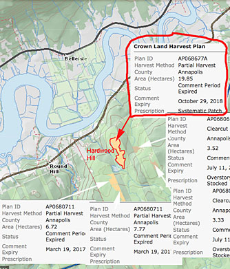
By the time local residents learned about the harvest proposed for their beloved Hardwood Hill, the comment period had expired. At least it was still posted on the HPMV. Now, such harvests will be removed once the comment period has expired “to simplify the mapping, speed up the application’s response time and adhere to the intention of the HPMV.” As well, the terminology has been chnaged to exclude the word “clearcut” altogether.
Two recent changes in the Harvest Plan Map Viewer (HPMV) and in the associated lists sent out to subscribers are causing significant doubt about that commitment to transparency and public consultation.
Most recently, L&F/Forestry Maps changed the description of harvests in a way that avoids mention of the word “clearcut” altogether (Post Feb 20, 2019). The change was introduced without explanation, and one wonders how it could have been done for any reason other than deliberately trying to hide the real extent of clearcutting in Nova Scotia, a major concern that led to two successive reviews of forestry in NS.
In the meantime, HPMV users try to figure out what in the new terminology corresponds to a clearcut under the older terminology. I have asked Forestry Maps/L&F for some clarifications.
Ironically, the change in terminology may make it very difficult for L&F to take credit for real changes in the extent of clearcutting/even aged management if and when that occurs. (L&F’s reticence about clearly distinguishing between even-aged and multi-aged management goes back even further – View post, Jan 23, 2017 and Question 2 in the NSDNR response to questions from HFN, Aug 24, 2018).
The other change was the announcement (Jan 30, 2019) that Forestry Maps would remove “harvest plans that are no longer open to comments” (View Post Jan 31, 2019).
Given that some controversial cuts had been identified in the fall of 2018 by nearby residents who saw the posts after the comment period had expired (and the government eventually responded to the concerns – view Post, Dec 17, 2019), there is widespread suspicion that this change was made to reduce difficulties for bureaucrats.
L&F offered the dubious explanation that removing harvest plans no longer open to comments was done “to simplify the mapping, speed up the application’s response time and adhere to the intention of the HPMV”. People had been asking for more information on the HPMV, not less! They had also asked for more specific communication with people in areas where cuts are proposed (e.g., by presenting the longer term plans for an area such as the Westfor map that appeared in a Shelburne County office) rather than to rely solely on the HPMV as the sole way to communicate.
Sometime back, even the locations of completed harvests were retained on the HPMV; those were removed in August of 2017 (View Post Aug 2, 2017), with the explanation (when I asked) that it was to “reduce clutter” on the map.
Both of those changes – removal of completed harvests, and removal of harvests once the comment period has closed – mean, of course, that when a new harvest is proposed, viewers cannot see on the HPMV what other harvests might have been conducted in the area recently, or at least from the time the HPMV was introduced in April of 2016.
Apparently such landscape level information is considered the business of the proponent forestry concerns and of L&F alone – yet both have clearly failed to carry out any significant landscape level planning, a major criticism of the Lahey Report and a key factor in the legal action being taken to enforce the Endangered Species Act.
Some inferences about past cutting on Crown lands and cutting on adjacent private lands can be made by viewing one or more of Google Earth, the Nova Scotia Provincial Landscape Viewer, Global Forest Watch Interactive Map, Google Timelapse, but often the most recent few years are not available on those tools and of course they do not identify specific Crown lands – such info resides with L&F alone! Why do they sit on it?
L&F’s explanation that they do not include such information in order to reduce clutter is simply not believable, as the HPMV already makes use of “layers”; the default presentation could exclude such information, while making it available in separate layers.*
_______________
*View also What you get and some of what you do not get on the Harvest Plan Map Viewer
A couple of posts by Minister Rankin on Social Media provide some glimpses into what’s going on currently at L&F (extracts of discussions are appended at the end of this post):
(i) Prof Lahey is now working within L&F on implementation of his recommendations.
(ii) The Independent committee of Technical Experts recommended by Lahey has indeed been formed.
(iii) Some sort of attention is being given to providing more info to the public about what’s going on in L&F (“I have discussed how we can provide regular updates with staff this morning. We have teams already assembled for the priority items.” and “I plan on sharing what our teams are focused on this week to the public and have a more structured way to ensure the public is informed of the progress”).
(iv) Minister Rankin was concerned enough about the issues raised by the Annapolis Facebook group surrounding L&F’s mistaken posting of at Corbett-Dalhousie Lake forest that Minister Rankin himself visited the site, specifically to look at how his department is handling identification of Old Growth in proposed harvests.
Given all of that, I find it even more difficult to understand how the recent changes in the HPMV could have occurred, as they seem totally at variance with the spirit of the Lahey Report and with specific recommendations of the Lahey Report.
Certainly they have not helped to reduce public concerns about clearcutting or helped to increase trust in L&F, with citizens now preparing to do more ground-truthing of proposed harvests.
To know that Prof Lahey is now working behind the scenes does not help either; rather, without any reports to the public 6 months after the Lahey report was submitted and with the actions by L&F in regard to the HPMV it adds to the sense of unease about what is going on within L&F and raises more questions. Were the changes in terminology discussed with the Independent Committee of Technical Experts or with Prof Lahey or even with Minister Rankin? Who is on that Committee, what are its terms of reference?
It all seems incredible given that the HPMV is the only vehicle for ongoing interaction/discussion between L&F and Nova Scotians at large about Crown land harvests, those harvests being identified and proposed not by L&F but by the forestry concerns that stand to benefit directly from the harvests.
=========================================================
EXTRACTS FROM TWO SOCIAL MEDIA DISCUSSIONS FOR REFERENCE
- From a discussion following a post on the Healthy Forest Coalition Facebook page on Feb 4, 2019
I was wondering whether an “independent committee of technical experts” been formed within L&F as recommended by Prof Lahey.
Minister Rankin responded
the recommendation on the evaluation was accepted, as per our response. It is being lead by Prof Lahey himself and staff have recently met with him to go over what the framework for evaluation will look like. I have discussed how we can provide regular updates with staff this morning. We have teams already assembled for the priority items.
2. From a discussion following a post by Michael A. Gerrior on the Healthy Forest Facebook page Feb 11, 2019:
MAG: “Good day everyone. As the HPMV is no longer useful to view what has happened on the ground, what other resources are available to view or find out what happens to Crown lands after a harvest proposal goes past the expiry date for comment and is removed from the map?…”
BW to MAG: Bev Wigney Michael A. Gerrior – That’s a good question. So far as I know, there is no way to know what is happening anymore. I’ve asked for some kind of update on the Corbett-Dalhousie Lake forest — the hardwood parcel — and have written to Iain Rankin asking about the outcome of his discussion with his staff and the licensee with regards to what they propose to do with that forest…
Iain Rankin: [I have broken IR’s lengthy post into shorter paragraphs (which you can’t do on Facebook) to make it a little easter to follow]
Hi Bev. My official response should be sent soon. I had the discussion with staff, and West for onsite on Feb 1st and provided notes to be drafted in our correspondence which is important to track officially.We toured the area [in the Corbett-Dalhousie Lake forest] that has been harvested, and the area that is approved with the same treatment. I brought our old growth specialist and we reviewed the areas retained for quality and biodiversity considerations.
As you mentioned I made it explicitly clear that this area should not be followed up with an overstory removal, but I will say that Westfor did not intend for that and is committing to multi-aged management in these stands.
In relation to Mr Patriquin’s concerns of old growth bring [being] included in Pre-Treatment Assessments (PTAs)*, we currently include the flag for identification that Old Forest Scoring is required if a certain threshold of larger diameter trees are present. I have learned that this has been only in place since June of 2017. So, if there are a lot of large diameter trees, then old forest scoring must be completed to determine if it is old growth. If the scoring identifies a forest stand where 30% or more of the basal area is in trees 125 years or older, at least half of the basal area is composed of climax species, and not had any recent harvesting, it will be set aside for conservation.
_______________
*Minister Rankin was referring to an exchange on documented in a Post Jan 18, 2019. I appreciate Minister Rankin acknowledging my concerns, however, the comment he makes above does not relate to the point I was making, which was that under the protocol he is describing, which involves sampling and decisions based on whole NSDNR/L&F identified stands or polygons, they are likely to miss most remaining patches of Old Growth in NS which occur in sizes smaller than whole polygons and/or are not otherwise aligned with polygons. View The Polygon Problem.Dr Peter Bush and others are also working on improvement of the PTA flag – The diameter threshold currently being used in the PTA is being evaluated by a student at Saint Mary’s University through a grant from the department. This research was a recommendation in the Department evaluation of Lawlor Lake Old Forest Assessment Report (Spring 2018).
I wanted to see this area personally and better understand how the promotion of older long-lived species and multi-ages will be sustained over time. I plan on sharing what our teams are focused on this week to the public and have a more structured way to ensure the public is informed of the progress.
——————————————
Please comment on NSFN content via WWNS; you can simply reference the content or URL* on NSFN in a post on WWNS. *For this post the URLis http://nsforestnotes.ca/2019/02/24/recent-changes-jan-30-feb-20-2019-in-harvest-plan-map-viewer-increase-concerns-about-clearcutting-in-the-nova-scotia/
