
Given the Lahey Report & Recommendations, why are we still making harvest decisions on Crown lands based on a narrow spectrum of highly specialized information that few can critique and on a process that has essentially been discredited?
UPDATE Jan 8, 2019: No response to comments submitted from ForestryMaps. View COMMENTS SUBMITTED below
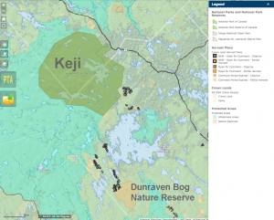
Screen shot of Harvest Plan Map Viewer, Sep 20, 2018. Titles added for Keji and Dunraven Nature Reserve
A bit of a rant so here’s a table of contents:
– Introduction
– Why is Biodiverse Southwest Nova Scotia is at Risk?
– Two major issues from a biodiversity perspective
– (i) Connectivity of habitat
– (ii) Soil nutrient depletion/severe acidification of surface waters
– A few links
– Some related comments on WWNS and HFC Facebook Pages
Introduction
The proverbial 40 days and 40 nights have passed for comments on forest harvest plans on Crown lands in SW Nova Scotia/Queens Co. announced Sep 19, 2018.
And little has changed one year plus since the Independent Review was initiated and two months and running since Prof Lahey delivered his report.
Crown land harvest decisions are still being made on a stand by stand basis with next to no landscape level planning (i.e. no reference to earlier and planned cuts on Crown and private lands in the area and how those affect ecosystems and species) and the only possible brakes on the process depend on reviews of the posted plans by Nova Scotians, those to be provided within 40 days. The plans we are to review consist of locations and the type of harvest on the HPMV (Harvest Plan Map Viewer), and the spread sheet PTA (Pre-treatment Assessment) results which are provided only if you specifically request them*.
Few Nova Scotians would likely be familiar with the precise sites a priori, fewer still would have the time and be able to visit them, and fewer still would have the type of expertise required to interpret the PTAs and site conditions and conclude all is OK or otherwise convince NSDNR/L&F in their language and on their terms that the harvests are inappropriate and comment on how they might be adjusted.
___________________
*There’s a dearth of related info on the HPMV such as the history of cutting in the area and info on volumes, species, forest development stage etc. some of which is provided on the NS Landscape Map Viewer, but no reference is made to that set of info., nor are comments on specific harvests by L&F’s regional biologists given.
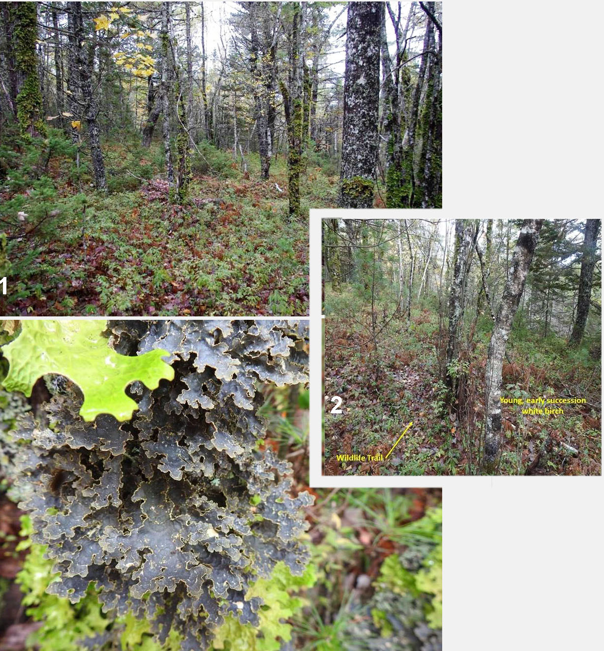
Photos by B.B. and D.C. 1: Proposed clearcut south of Kejimkujik National Park and National Historic Site with poor understory flora from nutrient depletion.
2: Another proposed clearcut by WestFor in young forest barely starting to mature.
3: Despite poor soils, some stands proposed for clearcutting feature lichens that are rarely seen in other parts of North America, such as Yellow specklebelly (Psuedocyphellaria perpetua). This lichen is destined to disappear along with the trees it grows upon.
A couple of people in the Healthy Forest Coalition actually visited some of the sites close to Keji Park and commented on the low wood volumes and lichens (left) and poor soil (below).
Will those comments and perhaps others submitted to L&F change any decisions? Based on past history, there’s a pretty low probability of that happening, and if they are changed, don’t expect any announcements about it or explanations to be provided by L&F.
Value laden comments (e.g. there is just too much clearcutting) hold no sway in the stand-level decisions.
The Lahey Report (as the Report on the Independent Review of Forest Practices is colloquially known) addressed the broad concerns expressed by many Nova Scotians and found that most are scientifically and socially justified. Prof. Lahey made very specific recommendations on how they should be addressed.
For a brief moment, it looked as though the Government/L&F would be moving promptly on the Recommendations, but they quickly backed off. (Also view Post, Sep 19, 2018).
So we return to the battleground as it was a year ago, restating all of the arguments about forests and forestry that were stated over and over again while the Independent Review proceeded and otherwise attempting to address current plans on Crown land on a stand by stand basis.
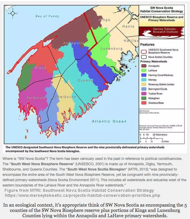
I use term “Southwest Nova Scotia” as synonymous with the Southwest Nova Scotia Bioregion as defined by MTRI (2013), i.e. the 5 counties included in the SW Nova Biosphere Reserve plus portions of Kings and Lunenburg Counties lying within the Annapolis and LaHave primary watersheds. Click on image for larger version and more explanation.
So here’s my version of why we need to move quickly on the Recommendations of the Lahey Report to prevent massive loss of biodiversity, ecosystem services and carbon storage in SW Nova Scotia; and with such losses, loss of a lot of what makes SW Nova Scotia an attractive place to reside and to visit and that supports many livliehoods.
Why is Biodiverse Southwest Nova Scotia is at Risk?
South West Nova Scotia is a biodiversity hotspot, a fact long known to ecologists and recognized by UNESCO’s designation of the South West Nova Biosphere Reserve in 2001.
Southwest Nova Scotia is “home to 75% of Nova Scotia’s species at risk” and includes a high concentration of Crown land and Parks and Protected Areas:
For sources, view NS Parks and Protected Areas Interactive Map, Southwest Nova Biosphere Reserve, and Southwest Nova Scotia Habitat Conservation Strategy Click on image for larger version.
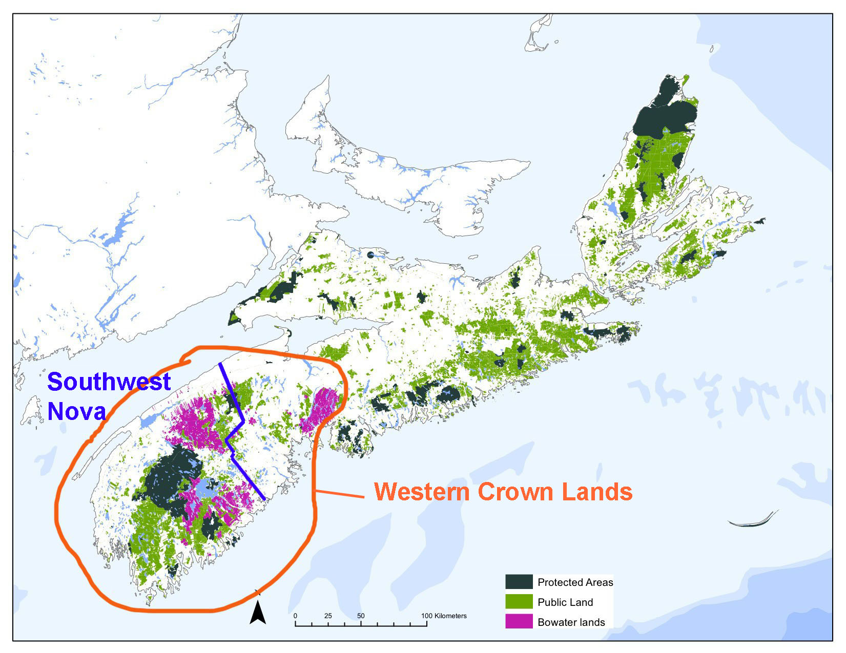
Western Crown lands, modified from CPAWS map (2012). The Bowater Lands, purchased in 2012 by the province for $117.7 million, are now part of our Crown lands
It’s also a hotspot for Industrial Forestry, especially on the Western Crown lands where WestFor operates.
These two interests are increasingly in conflict, the Lahey Report (which was supposed to sort it all out) notwithstanding, at least as yet while we wait for a government response to the Report.
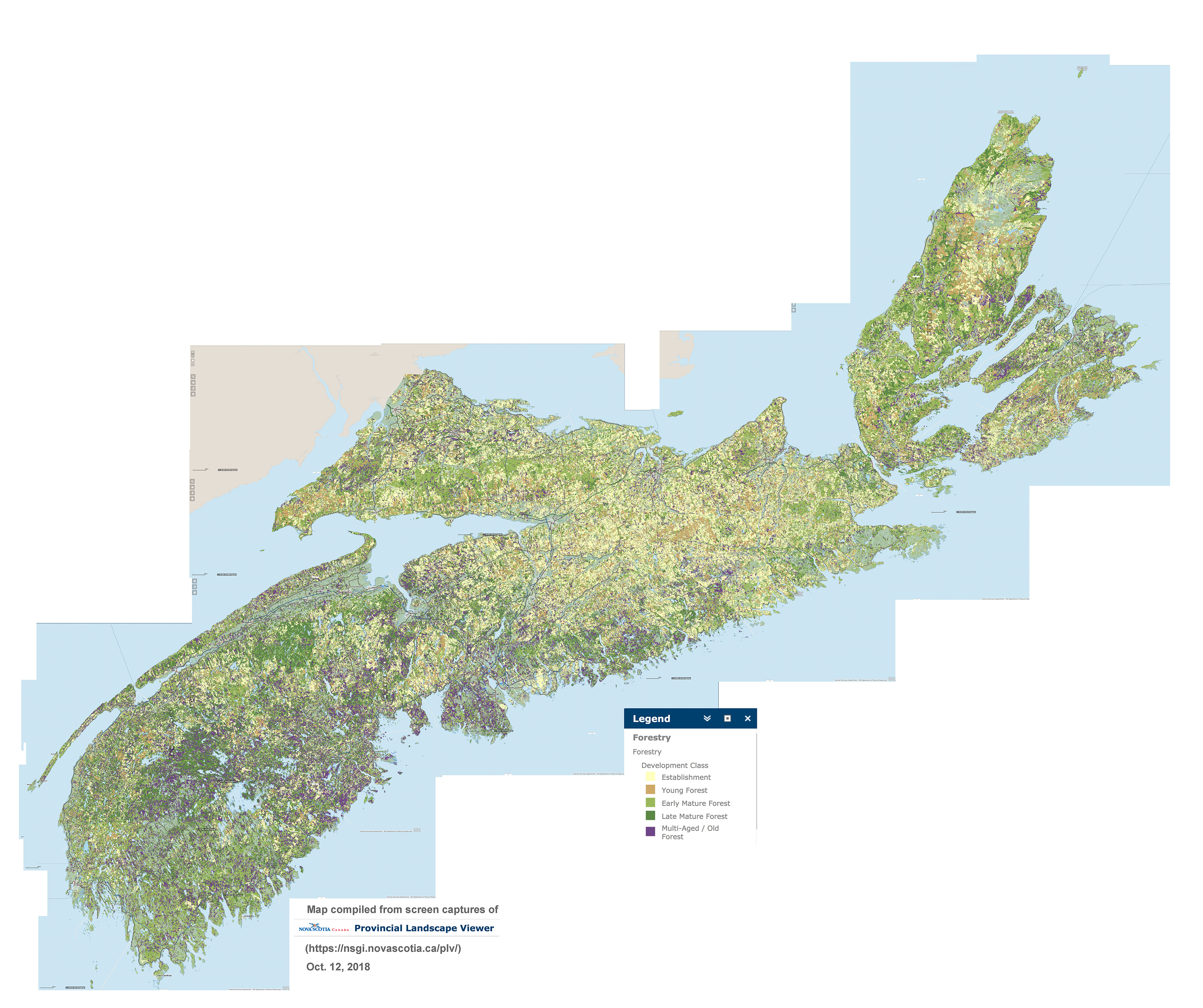
The map view below explains a lot about this conflict. It shows the distribution of multi-aged/old forest across Nova Scotia.
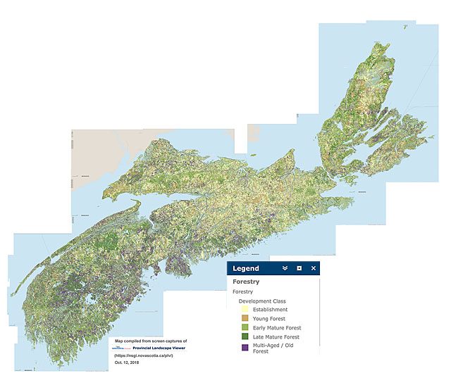
Distribution of forest in 5 development stages across Nova Scotia, compiled from NS Landscape Map Viewer. Purple = Multi-aged/Old Forest. View larger versions of the map: 2000 px | 4000 px.
(You may have to Save the larger image and open it on your device to view at full size).
More or less (and mostly more), the purple patches are also the forest stands with the highest wood volumes.
Below is a map of forest biomass in living merchantable trees prepared by NSDNR in 2008, showing the much greater overall wood volumes in SW Nova (2002-2006) compared to the rest of the province.
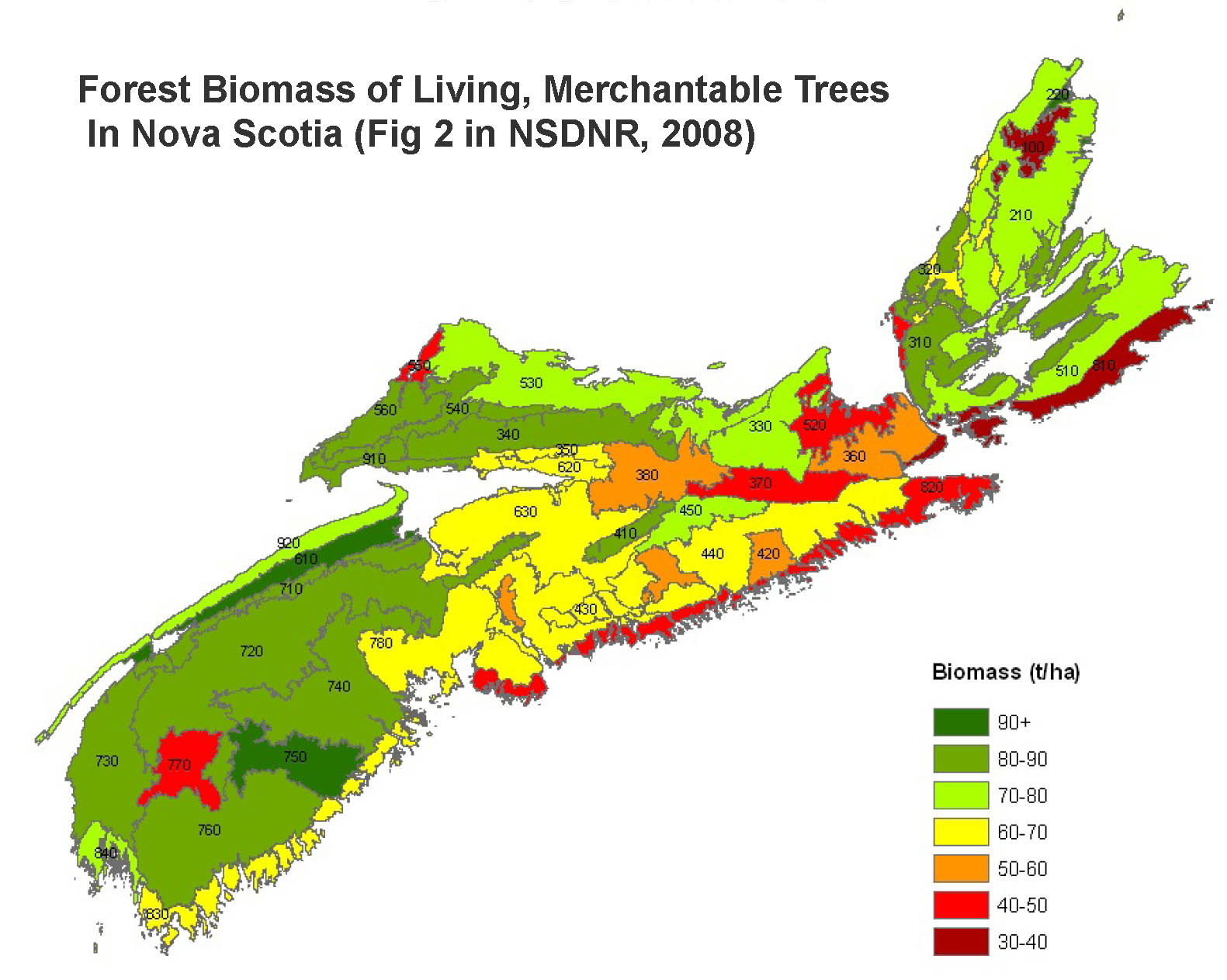
Map from Forest Biomass of Living, Merchantable Trees In Nova Scotia, NSDNR Report by Peter Townsend, 2008
SW Nova has been relatively lightly harvested since that time, particularly in comparison to central and northern NS:

Source: Global Forest Watch Interactive Map. Click on image for larger version. The red patches are mostly clearcuts conducted 2006 to 2017. Purple patches are mainly stands recovering from earlier clearcuts.
So… no wonder Industrial Forestry in NS wants access to SW Nova Scotia and especially the Crown lands, which occupy a large proportion of the area and have been described as the “the last great wood basket” not committed to pulp companies.
But isn’t it OK to harvest on patches of Crown land outside of those PPAs (Parks and protected Areas).. after all there are a lot of them, so what’s the fuss?
There are two major issues from a biodiversity perspective:
(i) Connectivity of habitat
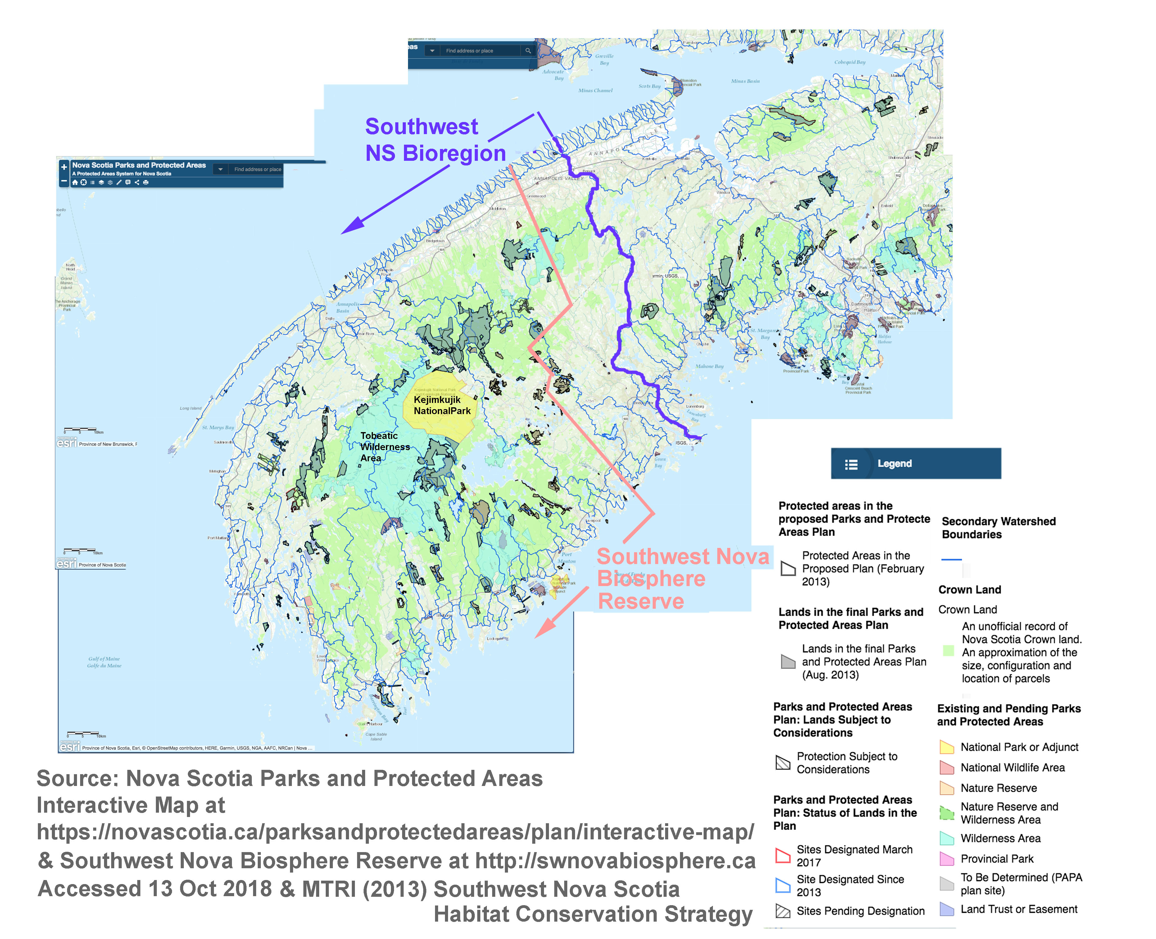
There is a large core area provided by Keji and the Tobeatic Wilderness Area, but outside of that, the PPAs are highly fragmented. This means that connectivity via “corridors of natural habitat” has to be provided to ensure that populations of different species in the fragments – and in the core – do not become highly inbred, or cannot be replaced if they are “extirpated” (go locally extinct).
Think of zoos as an analogy. Breeding stock is brought in from or sent to other zoos as necessary; and if a zoo loses a certain species, e.g., because there are only 5 individuals and they die from a disease, those can be replaced by imports from other zoos. Isolated patches of habitat are much the same as zoos except no one is going to monitor all of the species and move them back and forth… so we need a certain level of connectivity to ensure such exchanges can occur naturally.
Industrial Harvesting – including clearcuts and other even-aged management that maintains forest stands on short rotations – removes Old Forest habitat (the purple on the map above) which means that many species that depend on Old Forest habitat in the PPAs can be come isolated and in danger of extirpation. There is also the direct loss of the Old Forest habitat that is harvested, and the populations it supports.
So at minimum, when we conduct clearcuts/even aged management, we have to ensure that we conserve corridors of natural habitat. At least we need to do so if we want to maintain the integrity of our PPAs and ensure survival of our wildlife. Sensitively conducted, selective harvest of old forest on the other hand conserves most of the habitat.
‘Trouble is, consideration of landscape level issues does not happen when clearcut/2-stage clearcut harvests are proposed by Industrial Forestry; nor does it happen when the proposals are reviewed and finally approved.
The Lahey Report addressed this issue in several ways, notably through recommendations to
- make harvest decisions that favour uneven-aged management in the matrix (non-industrial/extensive forest management component) of the triad system* and more specifically in restricting clearcuts/even-aged management adjacent to boundaries of PPAs; (Recs 7, 9,10)
- improve abundance and conservation of old forests (Rec 17);
- expand the PTAs to encompass and address relevant wildlife issues (Rec 11);
- assess work underway for landscape-level planning (Rec 13) and more specifically to establish a land-use planning process for the Western Crown lamds (Rec 36);
- ensure the Endangered Species Act is fully implemented on Crown land (Rec 18) and private lands (Rec 29);
- review adequacy of and how to better address the ecological rationale for wildlife clumps and riparian zones (Recs 25, 26);
- provide incentives for private landowners to participate in the triad model of ecological forestry (Rec 31) and opportunities for carbon credits (Recs 32,33).
_____________________________
* Rec #4:”Nova Scotia should explicitly and strongly embrace and robustly implement the triad model of ecological forestry and seriously develop each of its three legs: the conservation leg, the high
production leg, and the intervening landscape (or matrix) where conservation and production objectives are both applicable and combined.”
Note added Oct 31, 2018: The World Wildlife Fund released its latest Living Plant Index on Oct 29, 2018. It shows a decline of 58% in populations of mammals, birds, reptiles, amphibians and fish across the globe between 1970 and 2012, with habitat loss and fragmentation a major cause. “If current trends continue”, says the WWF, “the decline could reach two-thirds by 2020”. For Canada:
Also view: Protect the last of the wild, by James E. M. Watson et al. in Nature, Oct 31, 2018: “Global conservation policy must stop the disappearance of Earth’s few intact ecosystems, warn James E. M. Watson, James R. Allan and colleagues.” |
(ii) Soil nutrient depletion/severe acidification of surface waters
Southwest Nova Scotia is ground zero for soil nutrient depletion (especially calcium) and severe acidification of surface waters.
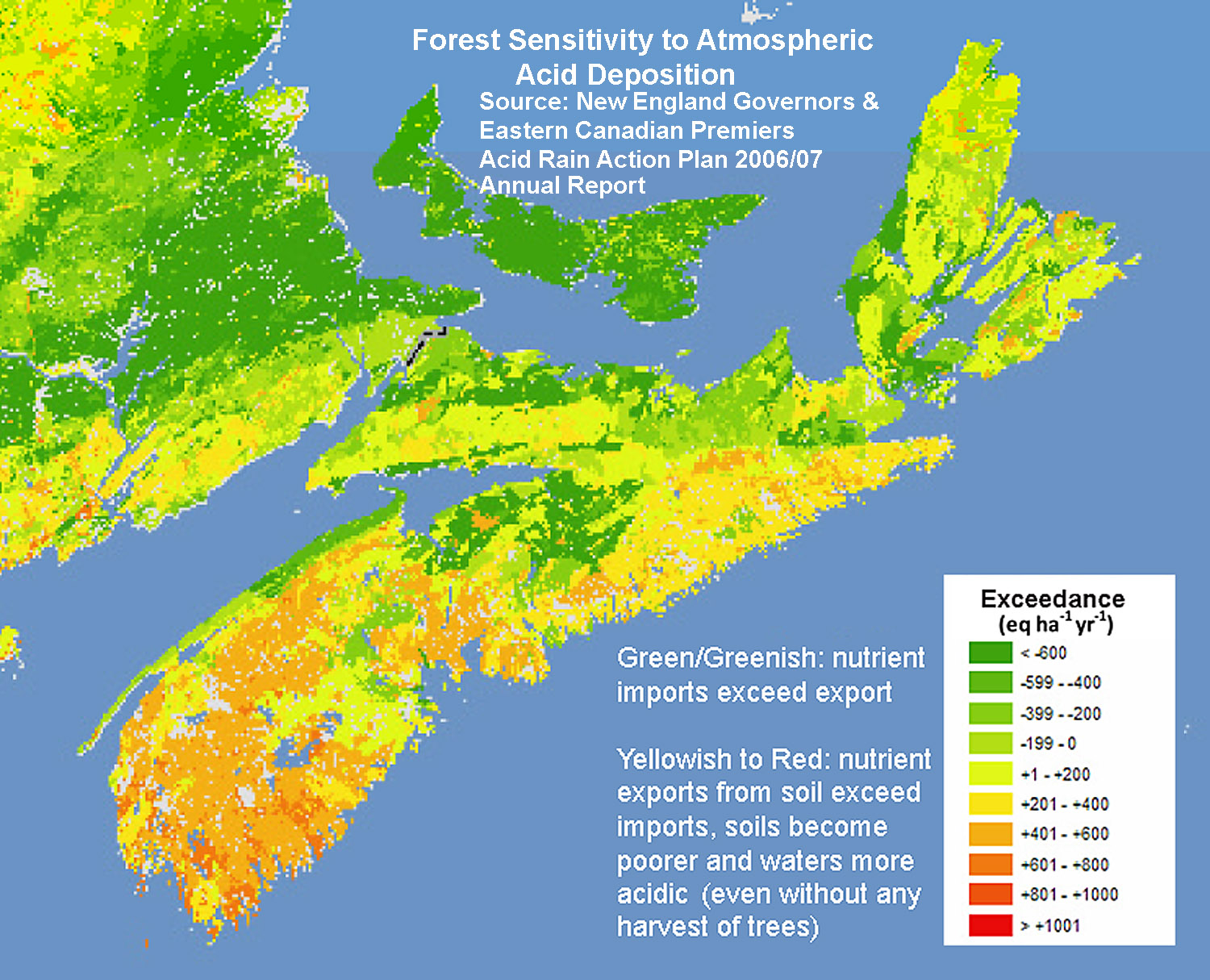 Click on image for larger version At left above: The overall pattern of nutrient depletion in NS’s forest soils was clear over 10 years ago as shown in this figure (adapted from Miller, E. et al. 2007. Mapping Forest Sensitivity to Atmospheric Acid Deposition. Conference of New England Governors and Eastern Canadian Premiers Forest Mapping Group Report). The brighter the colour the poorer the soils, a result of the inherently poor buffering capacity of the soils developed on hard, nutrient poor rock (they are amongst if the not the most nutrient-poor forest soils in N.A.), and acid rain. Those patterns have been confirmed and mapped in more detail by Kevin Keys of L&F, and Keys et al. (2016) concluded that clearcutting contributes to further nutrient depletion and soil acidification. |
 Click on the image for a larger version and source. At right above: Nutrient depletion of the soils has resulted in severe acidification of surface waters. The Map shows watersheds of the endangered Southern Upland salmon populations and the average pH of surface waters. Salmon populations in SW Nova Scotia have been the most severely impacted by acid rain. “Salmon populations in extremely acidified systems ([RED] pH <4.7) are thought to be extirpated (13 rivers), reduced by 90% in moderately impacted systems ([YELLOW] pH = 4.7-5.0; 20 rivers), reduced by about 10% in slightly impacted systems (pH = 5.1-5.4; 14 rivers), and apparently unaffected when pH >5.4 (13 rivers) based on research in the 1980s.” |
Much more than salmon are affected. Brook trout and a suite of aquatic invertebrates are seriously threatened, and acidification increases the toxicity of mercury, a big issue for loons and some other higher level predators of aquatic life. Declines in calcium under forests have diverse adverse effects either through calcium deficiency directly or indirectly through increased acidity, aluminum mobilization and enhanced mercury toxicity e.g., on cold tolerance of red spruce, sugar maple decline, forest salamanders and snails, forest herbs, invertebrates and song birds. (View 2014 letter for references.)
While Keys and Co. have conducted exceptionally rigorous science related to this issue, L&F has not highlighted this work on its website or in other publications (e.g., in the last State of the Forest report), and has not introduced soil acidification/nutrient depletion as a factor to be considered in the PTAs/Harvest Decisions, the excuse being that they still have to improve the model. I have argued that we don’t need stand level nutrient budgeting to apply what we know at least in a precautionary way and that clearcutting should be severely restricted in watersheds known to be excessively acidified (which is well documented). It is an argument that was apparently accepted by the Independent Review:
There is a strong argument to be made for managing forestry very carefully in watersheds with poor buffering capacity. Positive efforts should include limiting clearcutting wherever possible and ensuring that harvest cycles are sufficiently long for nutrients to be replenished by natural processes. From The Addendum Ch 6 Ecological Considerations Related to Forestry by Malcolm Hunter and Chris Wedeles
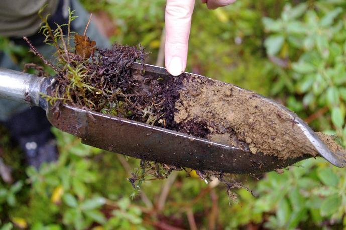
“Soil sample augured in one of the proposed clearcuts near Keji. The humus layer is less than a finger width before reaching the nutrient deprived layer below. The moss growing on top was about all that could be supported.” Photo and description courtesy of BB and DC
The areas proposed for harvest outside of Keji and Dunraven are situated in these highly nutrient deficient landscapes. Not only is the calcium deficient, but the organic layer at one stand examined by BB & DC was vanishingly thin.
Prof. Lahey’s recommendations on this score are also a little thin in my view, but the one Recommendation that is made is clear that this is an issue to be addressed on Crown lands in the Western Region (bolding mine):
16. DNR, with Crown licensees, must take immediate and sustained action – including by conducting or commissioning appropriate scientific research, engaging interested parties in collaborative problem‐solving forums, and adopting precautionary measures to be responsive to concerns about the potential adverse impact of forestry on Crown lands on the following interests:
a. Sensitive soils, particularly on Crown lands in the western region
b. Bird populations
c. Tourism operations and developmental plans
d. Outdoor recreation activities, including established trails
e. Protected Areas
I could go on but this enough of a rant already, and it’s hardly presenting anything new.
Have a look at Southwest Nova Scotia Habitat Conservation Strategy on the MTRI website and the associated 2013 Report (228 pages) for a lot more info on what needs to be protected in SW Nova Scotia. Have a look at the mapping of the Conservation Value Index (Fig 37 in the report, also at the bottom of the page for the Southwest Nova Scotia Habitat Conservation Strategy). It illustrates very well why we need landscape level planning now!
So given these concerns and given the Lahey Report/Recommendations, why are we still making harvest decisions on Crown lands based on a narrow spectrum of highly specialized information that few can critique and on a process that has essentially been discredited?
The longer we delay, the more we lose; I have little doubt that given the capabilities of modern Industrial Forestry, SW Nova Scotia would go the way of much of northern, central and eastern Nova Scotia within 10 years, and with it a rich natural heritage.
COMMENTS SUBMITTED
I forwarded these comments to ForestryMaps@novascotia.ca as input on the harvests proposed near Keji Park & Dunraven Nature Reserve as posted on the Harvest Plan Map Viewer on Sep 19, 2018. UPDATE Jan 8, 2019: No acknowledgment, no response to my comments. If they don’t like what comes in at ForestryMaps or feel they can’t address the concerns, they simply ignore it. Apparently.
——————–
A few links
Southwest Nova Scotia Habitat Conservation Strategy
MTRI, cited above.
Western Crown Land Planning Process – Updated August 2015
– Conceptual plan
– Guidelines for Biodiversity-Rich Landscapes (2015)
– Map (Large Scale)
The Northern Appalachian / Acadian Ecoregion: Conservation Assessment Status and Trends: 2006
Nature Conservancy
“John Pictou Carry”, Sporting Lake Stream, oil on birch panel by Mark Brennan, posted with permission of Mark Brennan.
Queens County clearcuts create concern
Nicole Munro in the Chronicle Herald, Sep 26, 2018
Ho Hum, more cutting near Nature Reserve in SW Nova Scotia
Post Feb 26, 2018
The legacy of Nova Scotia’s Tobeatic wilderness
Guest Post by Alain Belliveau, Oct 22, 2017
Clearcut Nova Scotia continued..17July2017 & how much wood can be harvested from one hectare
Post, July 21, 2017
——–
Some related comments on Woods and Waters Nova Scotia and Healthy Forest Coalition Facebook Pages
For the Record
HFC
Sep 19, 2018
ML: Check out the latest updates for the Harvest Map Viewer.
Queens County is getting the largest area harvested at just over 740 ha, or 1828 acres. 399 of those ha (985.5 acres) are clearcuts, the equivalent of just under 746 American football fields, for perspective.
So, the good news is that almost 50% of the harvests for Queens County are some form of partial harvests and that that 37% of the partial harvests are slated for individual tree selection. Unfortunately, the majority are uniform or strip shelterwoods, which some (including the National Forest Database) would call 2 stage clearcuts.
The bad news (besides, you know, an area not too shy of 2,000 acres getting clearcut in one county alone) is that around 100 ha (247 acres) of the clearcuts will occur within 3 km of Keji’s south-east border, many of them occurring roughly 1 km away. A further some 240 ha (592.8 acres) is also slated for clearcut across the province.
It seems to me that the Department of Lands and Forestry may want to hold the reins in a little more on the clearcutting at this point. The Lahey report outlines the concerns that many share; the general loss of faith in the forestry policy decisions being made at the Department of Lands and Forestry, their objectivity, and claims of ecologically-based forestry.
It saddens me to think of the lost potential of these lands.
Please submit your comments to ForestryMaps@novascotia.ca. We have until Oct. 29th to submit feedback.
Comments
NH: Thanks for bring that to attention, ML. Clearcutting in the riparian areas of Paddy Brook is of concern as this is critical habitat for the Threatened Eastern Ribbon Snake. This species will be beginning to make its seasonal move out of wetland hunting areas to find overwinter dens (hibernacula). Harvesting in the watershed of Keji is harvesting in what should be the buffer area of a Biosphere Reserve or barring that in the case of Keji, in the Cooperation Area where the local community works w conservation and industry to come up with agreeable solutions.
DGP: Also, some cuts are right up to the border of the Dunraven Bog Nature Reserve (to the south of Keji)
————–
Woods and Waters Nova Scotia
Correspondence between SH and Jonathan Porter at Dept. of Lands & Forestry re. clearcutting & moose
Letter to Jonathan Porter from SH
October 17, 2018
Subject:
RE: Harvest Plans Map Viewer Update
Dear Jon,
According to this article:
https://www.cbc.ca/…/nova-scotia-forestry-clear-cutting-mai…
Lands and Forestry Minister Iain Rankin says that if there are moose in the area designated for cutting, it would be considered in any approvals.
What does it mean that, “it would be considered in any approvals?”
QUOTE:
“That’s something our biologists look at and our whole integrated resources team, and then if there are known travelers in that area then we would specify special management conditions on the people that are harvesting,” he said in an interview at Province House.
My question is: 1. If there are moose in the area designated for harvest, what action is taken by your department?
We had a mainland moose in Ingomar, not far from where I live. I reported it to DNR – but there was no response. 2. Where are sightings recorded? 3. When people report sightings of species at risk etc, are harvests cancelled?
Thank you for your time.
Warmest,
SH
……………………………………………………………
Jonathan Porter response to SH
October 24, 2018
Subject: RE: Harvest Plans Map Viewer Update
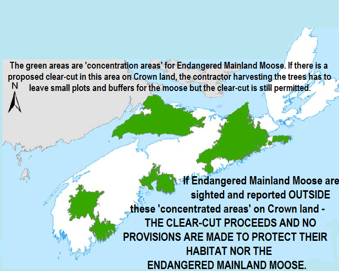
Moose are a very wide ranging species, and although they may be seen in a given location on one day, they may move on soon afterwards. Our biologists have used the available location data to map areas where we would manage especially for them. Although moose can be found at low densities anywhere on the mainland, these “concentration areas” are used to determine where our efforts may be of the most benefit.
When harvests are planned in one of these areas, the special management practices apply, which enable some harvesting but also require that specified areas be left for moose shelter. These procedures are available online and I encourage you to view them for your information (https://www.novascotia.ca/…/terr…/pdf/SMP_Mainland_Moose.pdf ).
I hope you find this information helpful.
Jon
……………………………………………………….
SH response to Jonathan Porter-
October 25, 2018
Dear Jon,
So this makes absolutely no sense to me from a conservation of an endangered species perspective.
It appears obvious that the only ‘managing’ (not protecting) of mainland moose that is occurring in the province is of the moose that “happen” to be living in a “concentrated area” and your department even permits harvests in concentrated areas! That’s not taking care of the endangered mainland moose population – that is allowing licensees access to resources at a cost to moose and their habitat.
Leaving buffers and plots in concentrated areas? Your department came up with that as a strategy to protect and recover endangered mainland moose? The entire concentrated area should be OFF LIMITS of harvesting! Give them an eco-system to live, thrive, reproduce – without threats – accessible logging roads and removal of habitat!
And if I have interpreted this correctly – what you are saying is that if an individual endangered mainland moose is spotted and reported on Crown land where there is a proposed harvest – outside the concentrated area – absolutely NOTHING is done to protect that moose? The forest is just completely removed and trucked off – with no regard for this endangered animal?
That’s just absolutely backwards! So this approach is not about saving and restoring moose numbers – it is a way for DNR to permit WestFor and Port Hawkesbury Paper to have access to all Crown land in Nova Scotia to harvest – with the exception of “concentrated areas” – where you STILL allow harvesting – leaving three hectare plots of land and some buffers for the moose to live…pathetic strategy Mr. Porter! How can protection get better than that?
This is absolutely a crazy way to PROTECT endangered animals!!! We can see who is the priority! The 13 mills including Northern Pulp – and not the moose! Your department is not working to save the moose – they are working to find a way to cut down more trees!
From June to October 16, 2018, 15,151.01 acres of Crown land are proposed for harvest. I bet within these 15,151 acres there are endangered mainland moose. – and NOTHING is being done to protect them.
That – is sickening. And this is nothing new…you already know this – your own people point this out in this article!
https://atlantic.ctvnews.ca/can-nova-scotia-s-mainland-moos…
So my question is: What are you and your department doing about the issues raised in this 2014 article to protect their habitat? Clear-cutting it is not a solution Jon.
– SH
Some Comments on WWNS:
RG: I travel the Joggins shore every day where they are now down to twigs they’re clearcutting. This is a concentrated area. The buffer zones they leave are very pathetic a start dying off themselves as their buffer zones have been removed. Natural forest develops in layers, remove the outlying layers and what you expose dies in many cases. This practice is totally ineffective and just not acceptable.
DAK: and…if they say the moose are travelling…where do they think they are travelling to if they keep clearcutting…and I have seen some so called buffers…wouldn’t support a squirrel some of them..
DS: And who is going to report any sighting? The only people that are allowed where they are cutting work for the company. Are they going to put their job on the line?
SM: Why are the roads gated and locked? So that the public ( who own the land) can’t see the damage done to the land and wildlife. Nothing trumps the money being made by the business who are clear cutting public lands.The “government employees ” are the not looking out for the public interest, but for the interests of the companies who profit from our resources.
———
An earlier post by SH on Healthy Forest Coalition website:
SH
October 20 at 4:16 PM
I’ve got to say – my heart has been heavy all day as I learned that an excavator has moved on site to prep an entrance to this forest to be clearcut in Shelburne County. NO HUNTING – TOTAL HARVEST signs have been posted. WestFor is moving south. AND WHAT ABOUT THAT LAHEY FORESTRY REVIEW? This is what I asked FORESTRY MAPS – and their response:
To: Forestry Maps <ForestryMaps@novascotia.ca>
Subject: So what has changed?
I recently received the harvest map dated October 16, 2018.
What has changed since the release of the Lahey report?
When are the harvests going to reflect ecological forestry and protection of species at risk?
Or is government just going to wipe their arse with the report and do nothing.
I am against all the harvests in this plan and all the plans proceeding it.
I could list all the reasons – but they have already been mentioned THOUSANDS OF TIMES…
-SH
RESPONSE FROM FORESTRY MAPS:
Ms. SH
Professor Lahey has completed a substantial report, and we are thankful for his invaluable work in leading this review. The department is studying the report in detail and hope to provide an initial public response to the report soon.
Forestry Maps
————and in the meantime————the clear-cuts continue.
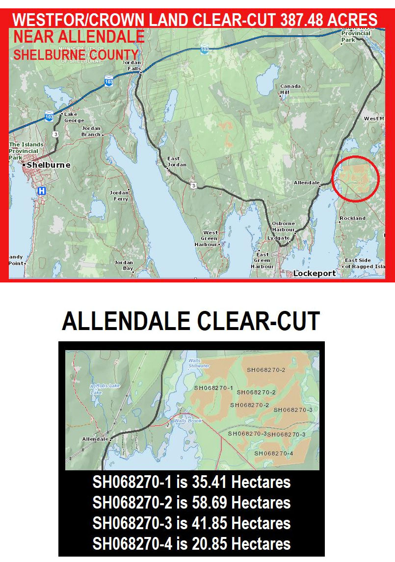
SH also commented: “We learned last August of an archaeological site VERY near this harvest and reported it to Heather Macleod-Leslie, Senior Archaeologist with Mi’kmaq Rights Initiative. It’s been a year and there was no follow up. We contacted them again to let them know that WestFor has started prepping the area. Is there anyone else this should be reported to?”
—–
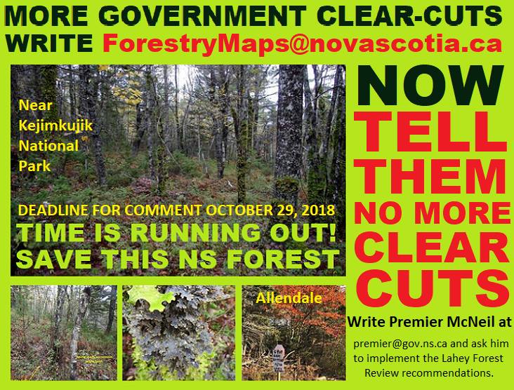
SHARE AND TAKE ACTION FOR OUR FOREST!!!!!!! DEADLINE TOMORROW – OCTOBER 29, 2018!!!!!!
THIS FOREST CAN’T TELL GOVERNMENT “”””NO MORE CLEAR-CUTTING”””” BUT WE CAN!!!!! —– AND IT IS URGENT THAT WE DO!!!!! E-MAIL ADDRESSES HERE: THE DEPARTMENT OF LANDS AND FORESTRY: ForestryMaps@novascotia.ca
AND PREMIER STEPHEN McNEIL:
premier@gov.ns.ca
Received this today!
More clear-cutting in the southwest- Quick! You can help stop reckless forestry!
Too young to die! Some of the latest public forests proposed for clearcutting are only 35-50 years old, far too young to be harvested, but poor direction from Lands & Forestry and corporate greed are ready to mow down more forests in the southwest. Some of these forests are located close to Kejimkujik National Park and National Historic Site and the Tobeatic Wildlife Sanctuary, while others are scattered on remote dirt roads with few to witness and record their untimely demise.
YOU can help stop this! These are your forests. Submit comments against the latest clearcuts (circled in black and easily found on Harvest Plans Map Viewer) prior to Oct 29th. Time is running out.
Lands and Forestry will facilitate more clear-cuts in our public forests, robbing young, nutrient-starved trees of a chance to advance through natural forest succession, to build soil and, to eventually grow better quality, healthier trees. They are also reducing future wealth, and robbing the next generation of its forests.
No computer? 1) Write or phone your local MLA; or2) phone a Lands and Forestry office and ask them where you can send your concerns; or 3) write the Premier and ask him to implement the Lahey Forest Review recommendations.
Figure 1 Proposed clear-cut south of Kejimkujik National Park and National Historic Site with poor understory flora from nutrient depletion. Photo: Bob Bancroft
WestFor has many clearcuts already approved, as they rapidly clearcut their way across the southwest.
BB and DC visited some of the stands about to be harvested near Kejimkujik, West Dalhousie, and Cherryfield and were surprised at the young, low quality forests that are about to be slashed. It is evident that much will simply be chipped. Described as “too young to die”, most have been recovering from human-caused forest fires that depleted soil nutrients long ago. Trees grow slowly, with poor, acid-loving plants like lamb-kill, bracken fern, and blueberry in the understory. Despite growing on the poorest and most fragile soils of eastern North America, these forests support wildlife and are useful habitat to deer, mainland moose, nesting birds, and other species. These forests provide vital buffering to streams that support trout populations.
———
BW on WWNS on oct 29, 2018 commenting on this NSFN post:
I’ve posted my submissions to the Harvest Map Plan site, and also the email I sent to the premier. I’ve just finished reading the linked article on NS Forest Notes — and looking at the photos of the forest which are about as I had expected for that area. Before I made my comments on the HMP, I looked up the maps and data for the Maritime Bird Atlas. All 4 squares of the area between the boundary of Keji and the lake to the south, seem to show quite rich bird habitat with many species respresented. It makes me quite disgusted to think that the forests in that area would be logged for such a pathetic amount of wood when they are providing habitat for so many species of birds, and no doubt for other creatures such as amphibians, reptiles, and mammals — and for understory woodland plants, lichens and fungi. I have often hiked in such places and they are usually abundant in all sort of creatures. Anyhow, what’s going on is just appalling — those in charge of this should be ashamed to want to log such immature forests growing on soil that is very unlikely to regenerate another forest in a human generation or two, or three, or more…. >:
——–
Oct 30, 2018: And I have seen a letter commenting on the specific sites and the PTAs and providing lots of reason in L&F’s language and on their terms why the current plans need to be changed, substantially.
Perhaps that will be enough, but more clearcuts are proposed… who can keep with them? It would be nice if L&F did, but in the public interest.