
Says Bev Wigney, “Why don’t you leave something for dessert?”
Or, just perhaps, for the Next Seven Generations.
Bev Wigney, today, on Annapolis Royal & Area – Environment & Ecology, a public Facebook Group. (Bolding inserted):
Hello Forestry Maps Entity,
I wish to comment on Parcel # IN205583 by email and not via the HPMV as I am including several maps and there is no way to do so using the HPMV platform. I’m including some maps as they are relevant to my comment.
While there are a number of reasons that this proposed harvest is objectionable, I’m going to focus on a matter that greatly concerns me and that has to do with the arboreal landscape mining that is taking place in the Cape Breton Highlands. Parcel # IN205583 provides a good example.
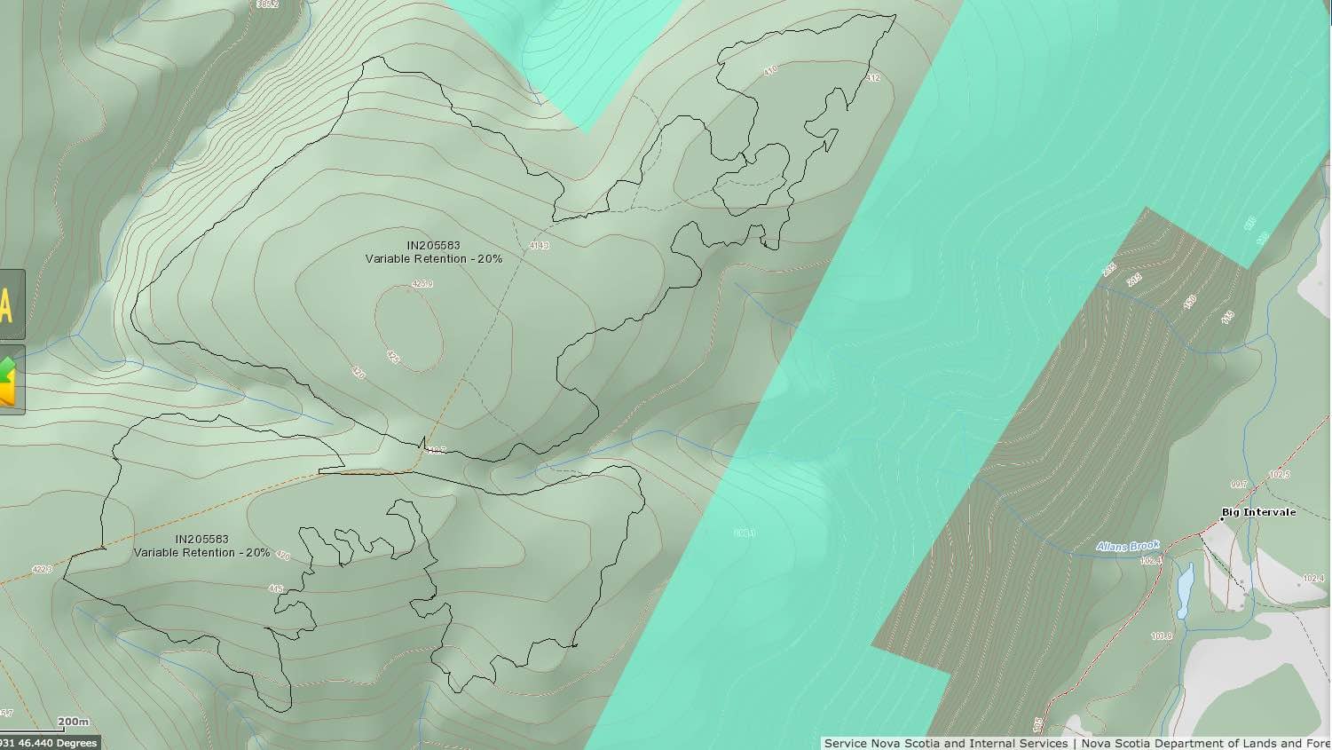
It consists of two adjoining sections which, when I consult the topographic layer on the HPMV, are located on what seem to be the highest points in the landscape — peaking at about 425 metres if the map is correct (I’ve made a screen capture and included that as an attachment).
Now, if we back off a bit and look at the other topographic map capture which I have sent — one which includes more area of the map — , we can see how compressed the topographic lines are to the east of the parcel — with a brook coursing through there too — Allan’s Brook — which flows down into the Northeast Branch of the Margaree River between Skye Lodge Pool and Wards Pool.
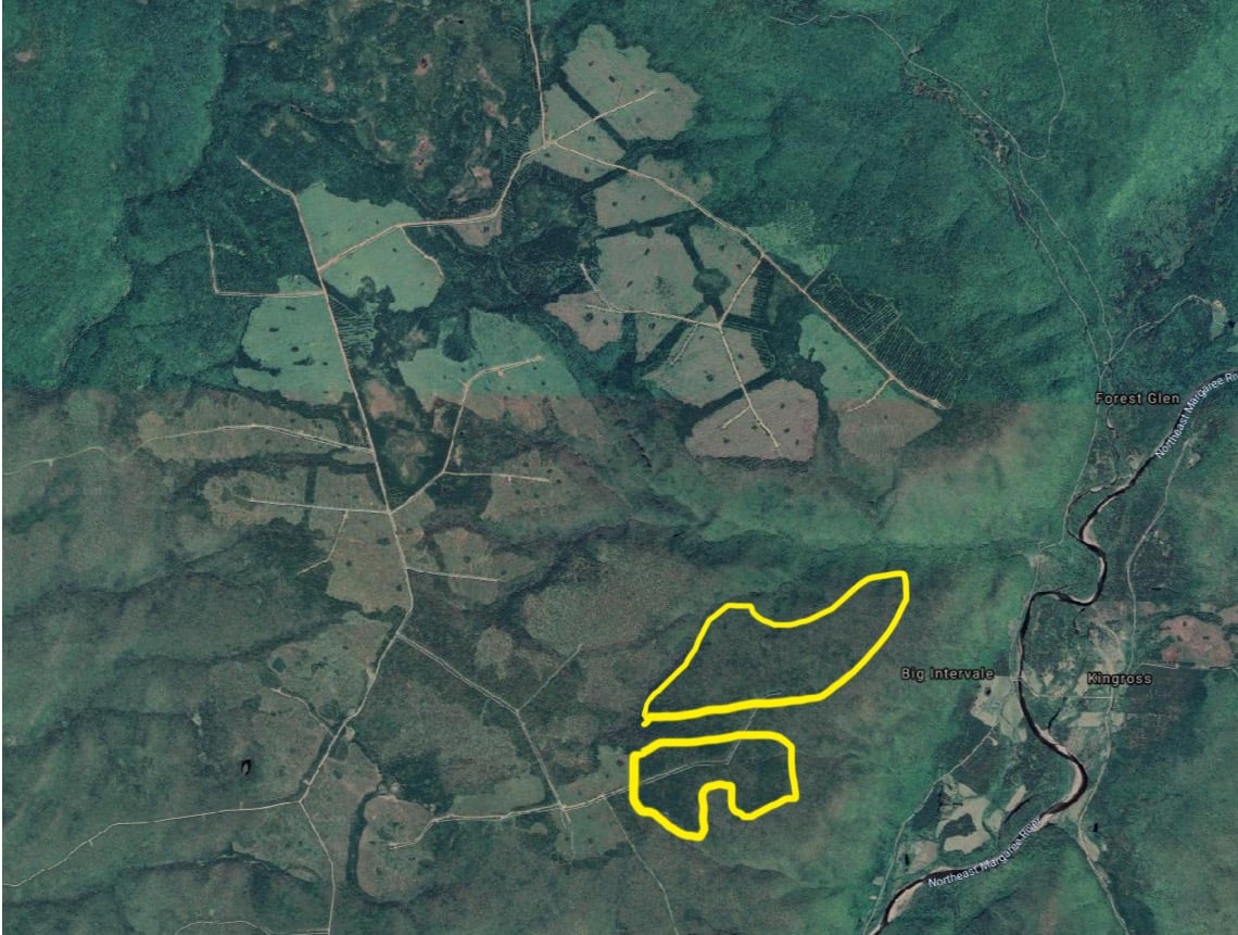
You know, I probably don’t have to tell you this, but the Margaree River has, for generations, been considered the greatest Salmon river of Nova Scotia — and, in fact, considered to be a world class Salmon River. The health of Salmon rivers is very dependent on good clean water, not too much acidity, not too much sediment. When I look at these topographic maps, and then at the other maps which I’ve attached — showing satellite views of the whole area surrounding these parcels — frankly, I don’t feel very optimistic about what’s going on in that area and its impact on Salmon. It seems to me that the way that industrial forestry is mining the forests on the very top of the highlands above the Margaree is playing with the future of the Salmon.
Now, take a look at those satellite maps. The IN205583 stand seems to be about all that is left up on the crests of those highlands to the west of that section of the Margaree RIver above Big Intervale. It looks like a lot has been clear cut with tiny wildlife “dots” here and there. Some looks like it was cut with no patches. Some looks to be variable retention leaving maybe 10 or at most 20% standing — and I’m assuming some are shelterwood cuts which will be “finished off” and cut down on a return visit.
As for the actual IN205583 parcel, when I inspect it closer with the Google satellite view, it looks like it may already have been harvested at some time in the past as the forest looks rather thin except a couple of patches in the more southerly of the two sections of the parcel and in the “hollow” — a gap through which Allan’s Brook flows between the two high points on the topographic maps, and that the greatest concentration of trees are on the north slope alongside the brook. So what’s up there left to be cut? Will you be removing the trees on the north slope facing into the hollow at Allan’s Brook?
Given all of the above, I’m really wondering *why* this parcel is being cut as a 20% retention. If you take out another 80% of what is left on the top of that highland, it’s going to leave very little forest remaining. It is also going to subject the landscape to erosion — into the brook which must obviously descend rather steeply into the Northeast Margaree River. It will also leave a very meagre tree cover up on top of the highest elevation above the river — and it will probably very subject to windthrow — which would then pretty much wipe out what remains of that forest. That won’t be good for the Margaree River and it will not be good for any wildlife in that area.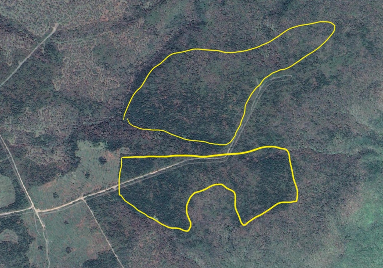
Anyhow, that’s my two cents worth about this parcel. I know that we commoners aren’t really listened to anymore, but I can’t help but speak up when I see such an egregious harvest plan come up for comment on the HPMV listing.
regards,
Bev Wigney
————-
And another comment sent to Forestry Maps just now::
PARCEL # IN205446 – Inverness County above the Northeast Margaree River
Hello Forestry Maps Entity,
Here is another comment — this one pertaining to Parcel # IN205446 in Inverness County, which is also above the Margaree River watershed. I am attaching a couple of maps with this comment.
I’m going to say pretty much what I said in my earlier comment about Parcel # 205583, about the perils of cutting 90% of the trees off the top of a very steep highland ridge. I’m attaching a topo map just in case you would like to refresh your memory of what that particular point of land looks like — the nearby peak of which it seems to be a part even has a name — MacLeod’s Mountain.
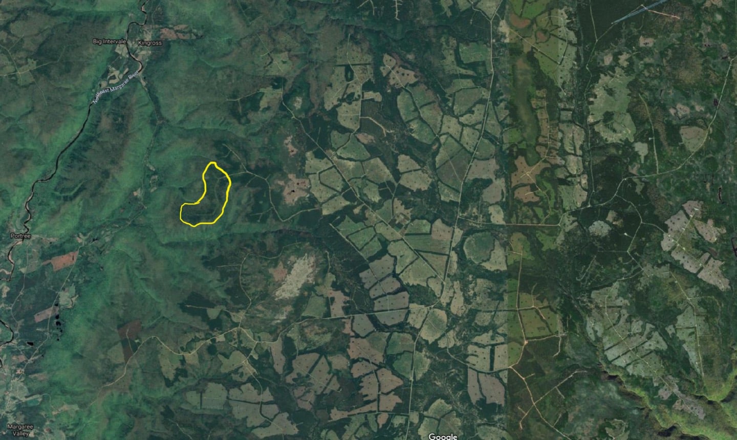
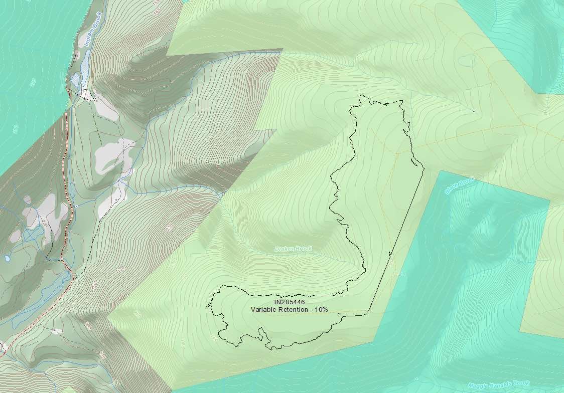
It looks like that ridge might have already had some logging done up there. Trees look thin in spots. On the satellite view, it even looks like there might be a bare landing in the road where logs may have been stacked on the crest of the peak. As you’ll see, the topo lines are very crowded coming down the west side where the drainage goes into Drakes Brook and on into Ingram Brook which meanders down to where it joins the Margaree at the spot called HATCHERY POOL. Wonder how it got that name? Must have something to do with SALMON, I would think.
I’ve also included a satellite view of the surrounding area, with Parcel # IN205446 marked in yellow. I will point out that you’ve already harvested very heavily in the whole surrounding area east of MacLeod’s Mountain. Now you’re going to take 90 percent of the trees on one of the last parcels between where you have already cut, and the Margaree Valley below.
Some people might say something like, “Haven’t you taken enough yet?” Where I come from, we have a saying that seems to fit this situation. “Why don’t you leave something for dessert?”
And in the regular news…
Jan 24, 2021:
– Fighting for forests in Cape Breton
Jessica Smith for Chronicle Herald. Subscription required. “Teacher concerned about how clearcutting affects wildlife. Large swaths of green. And dotted throughout: patches of beige, which show sections of cut forests. This is what can be seen in drone images from Sentinel Explorer, which indicate sections of the Cape Breton Highlands that have been impacted by clearcutting. …Adam Malcolm, a high school science teacher who runs the Stop Clearcutting Unama’ki Facebook group. …concern is that clearcutting heavily impacts forest creatures that won’t leave the canopy out into the open. So wide clear cuts, as seen in the drone images, with no connectivity between different sections of forest, create serious barriers to populations that would naturally have some genetic flow between them….”
– Clearcutting in Cape Breton: Where it’s happening and what’s being impacted
Jessica Smith for Cape Breton Pots. Subscription required/ “Clearcutting is a topic at the heart of Nova Scotia’s forestry industry, with a long, controversial history. In Cape Breton, the sector is vast and spans both Crown-managed lands and private woodland suppliers….”