
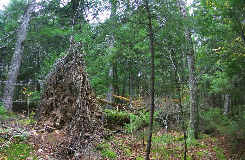
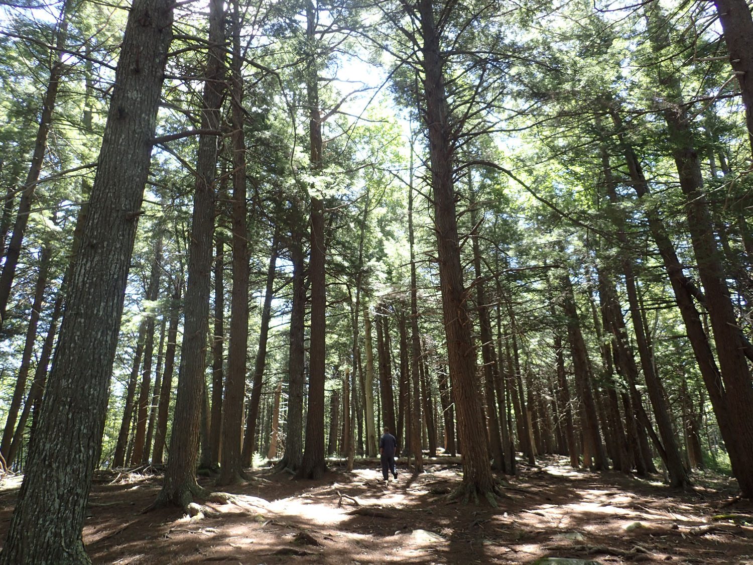
A pit and mound-forming tipover of a big old hemlock near Grand Lake, NS
Click on image for larger version.
Hurricane Teddy is tracking northward and “is expected to impact Atlantic Canada and the Gulf of St. Lawrence region Tuesday and Wednesday as a “very dangerous” post-tropical storm as it moves through the region, bringing strong winds, heavy rain, storm surge and pounding waves” (CBC Sep 19, 2020).
They might have added tree falls (tipovers, windthrows) to that list.
My spouse looks out the window at our urban forest and at a towering tree on a street one block to the north; she worries that it may fall to the southwest and on our house and asked me what I thought. “I don’t think we have to worry, at least this time around” I said. “Why”, she asked. I said “Because I looked at the tree, it is about 3.5 ft diameter and looks very healthy; it has already survived Juan and Dorian and right now it looks as though this storm will not be worse than Dorian and nowhere near Juan in ferocity; and even if the winds blow it over, it is likely to fall towards the west or north and not towards us.”
“Why do you think it wouldn’t fall in our direction?” she asked. “I have been thinking about windblown NS forests” I said.
—–
Unlike a lot or most of Canada, for which wind disturbance is not cited ( 21 Sep 2020) amongst the top natural disturbances of our forests, wind is a significant “natural disturbance” of forests in NS. (Fires and insects are the big ones for the boreal forest.)
The just published review of natural disturbances in NS forests by A.R. Taylor et al. (2020) cites 2 major categories of wind disturbance: windstorms and hurricanes. Following is a Coles Notes summary of some of the info on wind disturbances and their frequency in NS from that paper.
1. Windstorms
Wind intensity 50 -100 km per hour. Three types:
– Extra-tropical Cyclones (ETC), formed over ocean in mid-latitude temperate zones (30-45 deg); track west to east; most intense Nov-Mar; commonly called “noreasters” in Atlantic Canada, some with gusts of 100 km/hr, often accompanied by rain or snow and can cause widespread forest damage (e.g. White Juan), but most are of lower intensity.
– Tropical Storms (tropical cyclones), form over ocean in tropics (0-30 deg); generally track east to west but often veer north; most intense in Atlantic Canada during late summer to early autumn; max sustained winds 56-104 km/hr (above that the are classed as hurricanes); 1900-2019 average 1 every 4years; since 2000 four have landed, Dorian in 2019 was the most powerful with 65 km sustained winds and caused damage province-wide
– Convective Storms, produced over land, produce strong vertical downdrafts that track with with regional airflow; can cause narrow bands (1-10 km wide) of windthrow extending for kilometers, possibly small dispersed patches (100-1000 m2) of downed trees to widespread high severity windthrow over 100s of square kilometers.
The temporal aspects of natural disturbances are commonly described by Mean Annual Disturbance Rate (MADR) which is the average percent of the area that is disturbed in one year. The reciprocal of that is the Return Interval which refers to the time in years between two successive disturbances in a designated area (in this case the area encompassed by all of the forests of NS). So, for example, a MADR of 1% means that on average 1% of the forest area is disturbed each year, and the Return Interval is 100 years.
Disturbance Rates by Windstorms based on data from NS Permanent Sampling Plots 2009-2017 – Taylor et al., cite the following values:
– High Severity (>60% downed tree biomass) and Moderate Severity (30-60%) Windthrow had a MADR of 0.02% per year, equivalent to a 5000 year Return Interval
– Low Severity Windthrow (5-30%) was most common with a MADR of 1.4%/year or a 71-year Return Interval
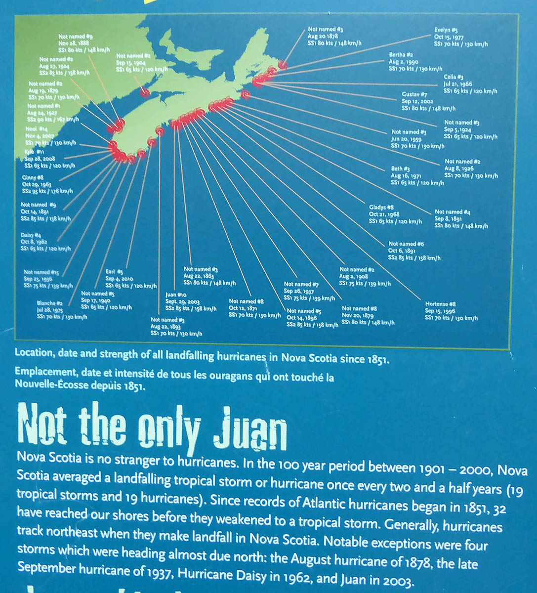
From an outdoor panel display at the Maritime Museum of the Atlantic on Nov 4, 2017
Click on image for larger version.
2. Hurricanes
Wind intensity 104 km/hr and greater.
Over the years 1900-2019, 13 SS1 hurricanes (104-134 km/hr) and 4 SS2 (135-154 km/hr) made landfall over NS; damage from hurricane Juan is best documented: 91, 484 ha of windthrow, 25% High Severity, 49% Moderate Severity and 29% Low Severity.
Disturbance Rates based on average 7 hurricanes per year and Juan type damage:
– High Severity (>60% downed tree biomass) MADR 0.08%/year or a 1250 year Return Interval.
– Moderate Severity (30-60%) MADR 0.14%, 714 year Return Interval
– Low Severity (probably underestimated): MADT 0.09%/year or a Return Interval of 1111 years
The disturbance rates in summary; I have added estimates from the paper for fire and spruce budworm outbreaks.
| TYPE OF DISTURBANCE | DISTURBANCE RATE | RETURN INTERVAL |
| High and Moderate Severity Windstorms (>30% windthrow) | 0.02% | 5000 years |
| Low Severity Windstorms (5-30% windthrow) | 1.4% | 71 years |
| High Severity Hurricane (>60% downed tree biomass) | 0.08% | 1250 years |
| Moderate Severity Hurricane | 0.14% | 714 years |
| Low Severity Hurricane (probably underestimated) | 0.09% | 1111 years |
| Moderate to High Severity Fire | 0.17%-0.4% | 250-600 years |
| Spruce Budworm Outbreaks | – | < 50 years |
So the type of natural disturbance we most commonly see in NS is Low Severity Windthrow. In general those create ‘gaps’ within our Acadian forests, and are characteristic of multi-aged forests. (Spruce budworm outbreaks have a lower Return Interval but they are much more restricted in their occurrence than wind disturbances in NS).
Every now and then, there is a larger scale, stand-levelling disturbance by fire or wind, and a successional process takes off after the disturbance has passed. Trees are initially even aged; eventually with bigger, older trees, a gap process and “stand re-initiation” begin and a multi-aged, multi-storied forest starts to develop (see Forest Dynamics).
Until Hurricane Juan came along in 2003, we had kind of forgotten about hurricanes in NS.
“Those of us that are under 50 years of age, and perhaps others, do not have the experience of what forest devastation can be caused by serious hurricanes such as Edna approximately 50 years ago. Most people seem to agree that we did not expect anything remotely like the intensity and damage caused by Juan. With respect to hurricanes, we have been lulled into a sense of false security. However, if we had been listening to some climate experts, we would have realized that in terms of climate history, we were overdue for a “big blow.” – From L&F: Impact of Hurrricane Juan on Nova Scotia’s Woodlands
One of the reasons, apparently, that it surprised even the storm modellers was that they had not factored in the effect of a 3 degree Celsius increase in the temperature of seawater water hugging the Atlantic Coast of NS.
More work will be done in order to quantify the influence of ocean surface water temperature on the intensity of hurricanes in Atlantic Canada. If the seemingly small departure of water temperature from 15°C to 18°C makes a significant impact on storm strength like we believe, then we should be very concerned about long-term trends in ocean temperatures. This could happen in an increasingly warmer climate or with changes in the dynamics of the warm Gulf Stream that may allow warmer waters to move toward Nova Scotia. – Environment and Climate Change Canada
So we can probably anticipate a greater frequency of Juans in future.
Regardless, our forests themselves provide visible records of past hurricanes in the form of “pit and mound” topography.
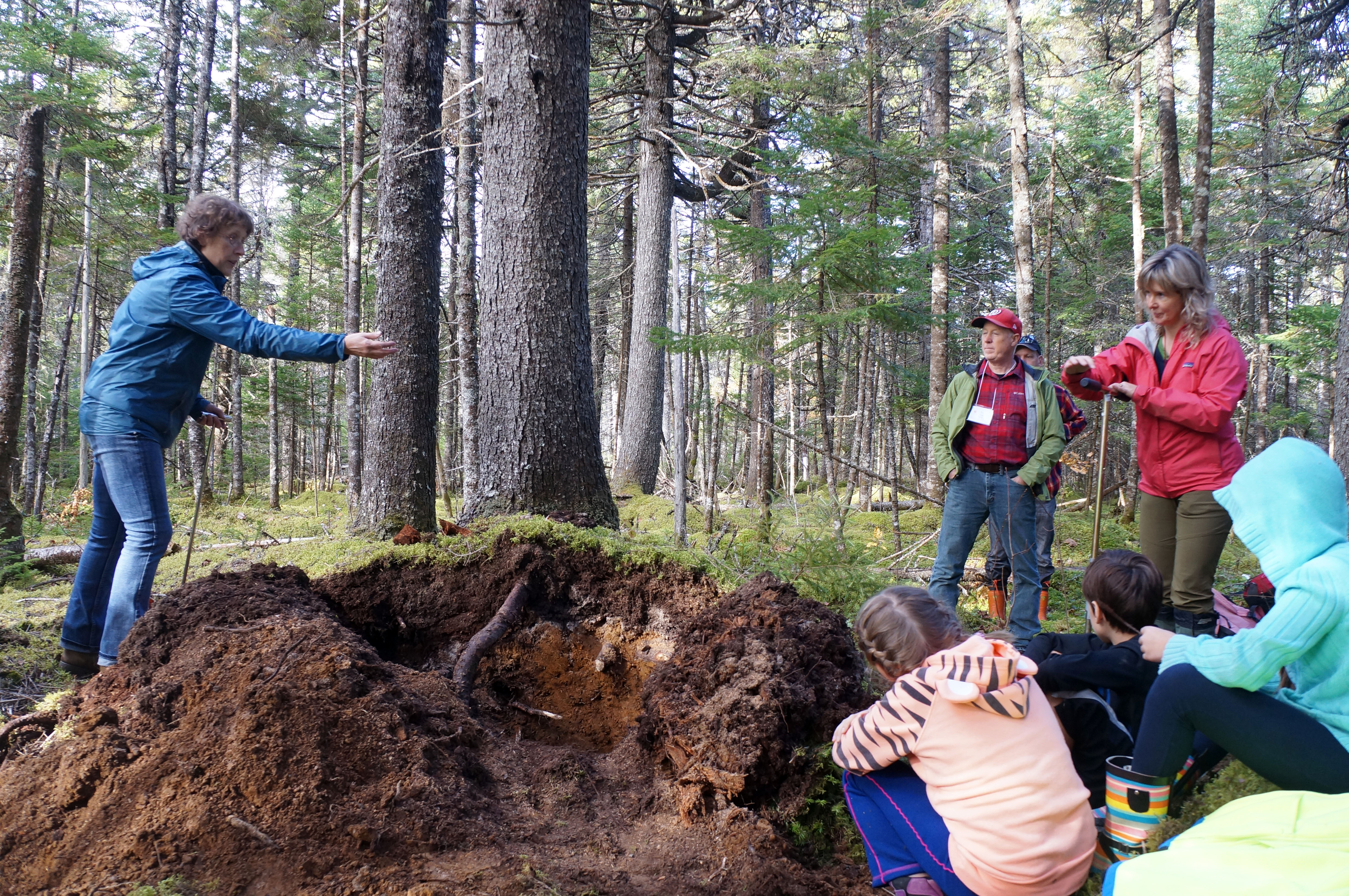
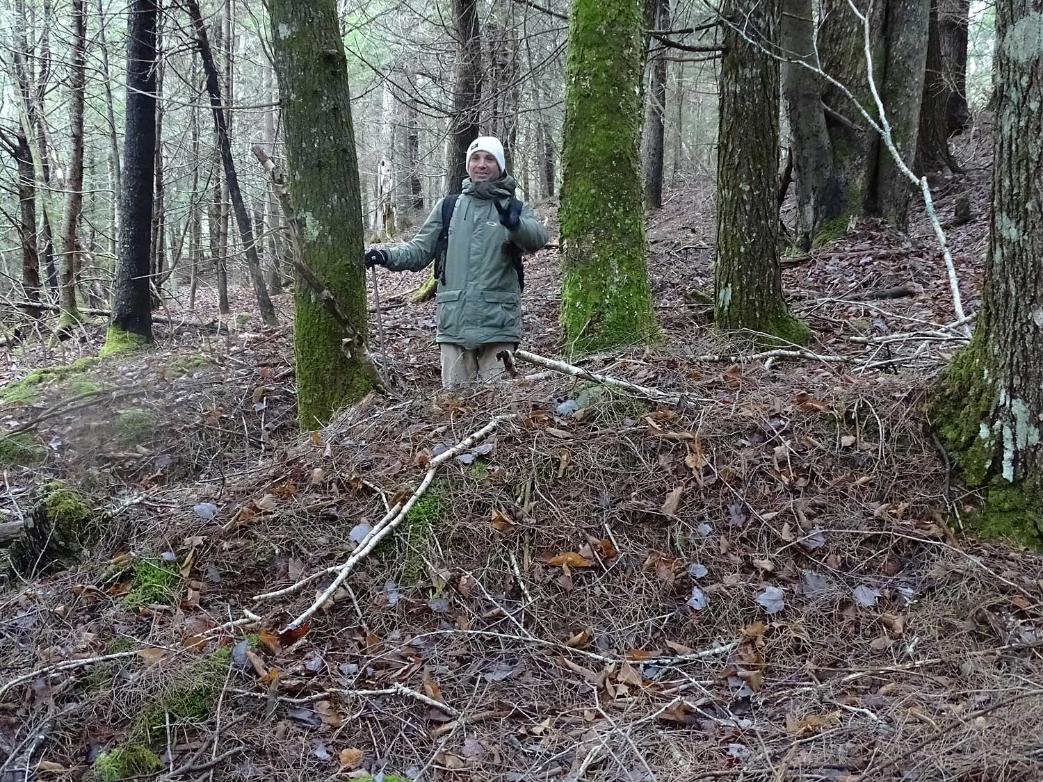
Dr. Elena Ponomarenko shows participants in the MTRI Old Forest Conference (Oct 19-21, 2016) how to read the forest floor to uncover past disturbances and forest types.
Click on image for larger version.
I became aware of the significance of pit and mound topography in NS forests when I participated in a MTRI sponsored Old Forests Conservation Science Conference at Debert in October of 2016. Elena Ponomarenko and Donna Crossland told us about the “pit and mound” topography that is found in a lot of old forests in NS, and how the mounds were formed by tip-over of very large, typically old growth trees in severe wind events 70 + years ago, and perhaps 100s of years ago in some cases; and how citizen scientists can collect useful data on the directions of the winds that caused the tipovers by looking at the orientation of the pits and mounds.
After that, I began to notice a lot of pit and mound topography in old forests I had walked in the past without particular notice of the topography, other than that there was a bit, or a lot, of ups and downs. Indeed, the more I looked, the more pit and mound topography seemed to be the rule in our old forests, except on very rough topography where there are a lot of outcrops and glacial erratics.
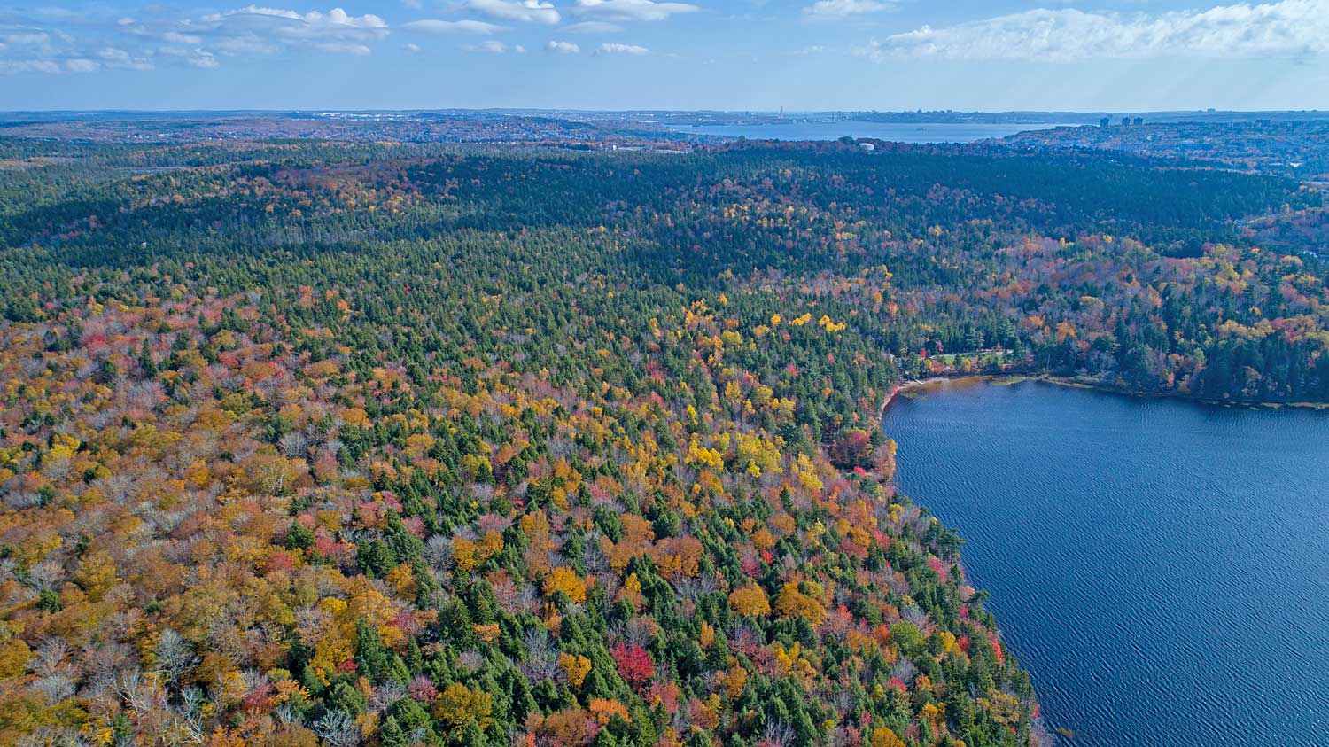
Forest by Sandy Lake on Oct 9, 2017; Bedford Basin in the distance.
Click on image for larger version.
By happenstance, in the summer of 2017 I was asked if I would do a floral survey of the landscape around Sandy Lake near Bedford, NS, for a group seeking protection of more of tho lands in the Sandy lake watershed, the biggest subwatershed of the Sackville River watershed. I said ‘I don’t do floral surveys of the sort you want, because I don’t know the rarer graminoids (sedges, rushes, grasses) well enough, but I will have a look at it to see if I think there are other features that might add to the conservation value of those lands.’
I met my contact person at the lake. He had a camp/cottage there…and right next to it was a stand with some very big, old hemlock/yellow birch – and pronounced pit and mound topography!
Cathedral-like grove of hemlock.
Click on image for larger version.
We paddled across the lake to “The Peninsula” with a cathedral-like grove of hemlocks, some over 200 years of age, and again pit and mound topography. We walked north along the shore through mixed Acadian forest, with patches of big old trees and pit and mound topography.
I was sold on looking further and spent the rest of the summer and fall traversing the area and I am still at it. I observed a lot more of the pit and mound topography in old forests variously dominated by white pine/red spruce, hemlock/yellow birch, sugar maple/yellow birch, and mixed woods.
Pit and Mound topography in hemlock/yellow birch forest by Sandy Lake. Based on the ages of the oldest trees, I speculate that they were formed following a massive windfall during the Saxby Gale (1869) or the Great Storm (1873).
Click on image for larger version.
In places, the pit and mound topography was like a series of waves across the landscape, all oriented in the same general direction. I measured the orientation of the tipovers that formed the mounds as I had learned to do at Debert, also of recent tree-falls including one swath which was likely initiated by Hurricane Juan.
I was surprised at the results. The tipover directions were mostly in the sector from about 285 degrees west through true north to 30 degrees east (~W to NNE), i.e. the winds came mainly from 105 degrees to 201 degrees (~E to SSW) but I figured they should be mostly in the north to east quadrat if the storms originated from hurricanes coming up from the south along the U.S. seaboard (winds from south to south west – also see Fig 5 in Taylor et al., 2020). I sent my graph to Donna Crossland, and she told me that Bob Guscott – a retired DNR forest pest specialist and also a “graduate” of the Debert pit and mound sessions – had done similar observations at Grand Lake about 40 km away. Well guess what he told me – he had found pretty well the same distribution of inferred directions of the treefalls that formed mounds he was looking at.
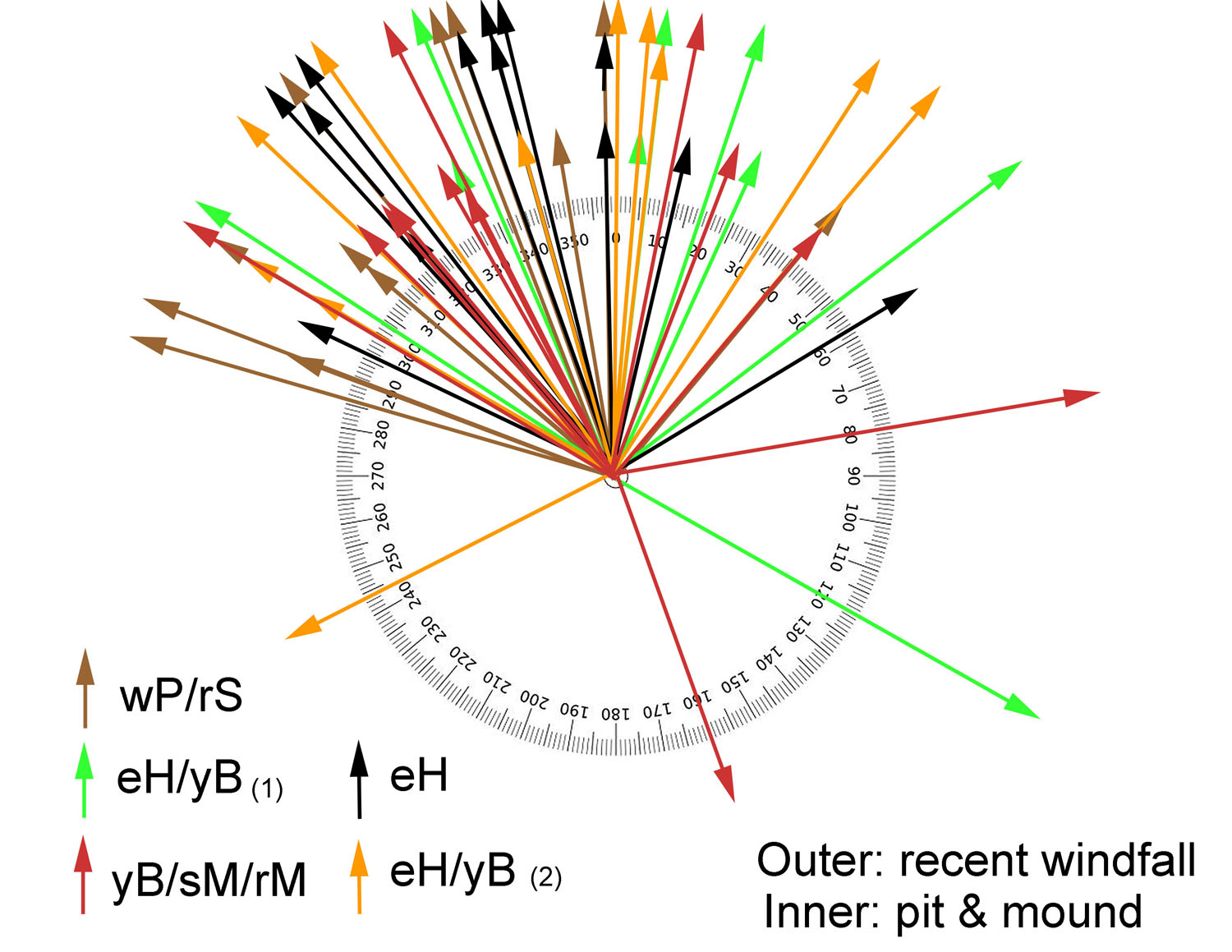
Inferred directions of fall of the tipovers that formed mounds, and of recent windfalls in forest by Sandy lake (Bedford, NS) . More about the observations here.
There’s more to my fascination with pits and mounds at Sandy Lake, some of which is reported on sandylakebedford.ca under Forests and its subpages.
Leaning about pits and mounds changed the way I looked at and experience old forests in NS. Now when I walk through a forest with pit and mound topography, I feel it is a bit like walking through a graveyard, the graves being the mounds containing the bases of big old trees that blew down in the past. But there is a more direct connection with subsequent generations than we have to our graveyards, as the tip-overs and in turn the mounds that they form are favoured sites for many trees species to get established; most of the big trees of today in these forests are growing on top of mounds, not in the pits. So I would describe the feeling as more like walking amongst the elders, or being very aware of the previous generations of trees and their influence, and of the big influence of hurricanes on our forests over time scales of a hundred + years.
Besides forming good habitat for tree establishment, there are other ecological benefits derived from tipovers and pit and mound topography. For example, the big tipovers are often used as hibenacula by bears. The pits often form vernal pools for a period, perhaps 10-25 years (until they get filled with leaf fall etc.) providing habitat for amphibians and other organisms requiring water for part of their life cycle. As the trees grow old and mounds erode, the tree roots are exposed creating cavities for wildlife between the roots and the trunk. The windfalls and formation of pits and mounds rework the soil, maintaining higher levels of productivity than would otherwise be the case.
Most of the pit and mound topography is disrupted when we clearcut, and high-grading (selective harvesting of the largest trees) also disrupts the process, so forests managed intensively for any length of time will tend to lose them. Interestingly, pit and mound topography is now relatively rare in new England forests which overall are far more intact and older now than our NS forests – that’s because most of the land was cleared for agriculture at one time but then abandoned in the late 1800s.
The Big Tree, a Tilia species.
Click on image for larger version.
So the common occurrence of pit and mound topography in NS forests, and the prominence of wind in our disturbance regimes (also in PEI and NB) compared to most of Canada are very special. I also think they have significant implications for how we practice Ecological Forestry in NS, e.g. in regard to salvage harvests, and how we designate stands as Old Growth.
Right now, however, I am turning my thoughts to Hurricane Teddy and wonder just how intense it will be when it hits NS – and whether that very big tree one street over will still be standing 48 hours from now.
UPDATE Sep 23 ~ 2pm: Weather warnings end in Halifax as Teddy heads to Cape Breton By: Meghan Groff in Halifax Today. Winds
Some related links and posts
A review of natural disturbances to inform implementation of ecological forestry in Nova Scotia, Canada
by Anthony R. Taylor et al., in Environmental Reviews Aug. 18, 2020
Digital Wind Exposure Map for Nova Scotia
K. Keys et al., 2017 DNR document
NOAA Historical Hurricane Tracks
Interactive map showing 150 years of historical hurricane landfalls
From Identification of Hurricane Juan Blow-Down Using Aerial Photography.
Click on image for larger version.
Identification of Hurricane Juan Blow-Down Using Aerial Photography
Renewable Resources Branch, Forestry Division Forest Inventory Section, July 2004 20 page document with photos and maps.
Images of Hurricane Juan’s Aftermath
On L&F website
Patterns of pedoturbation by tree uprooting in forest soils
Bobrovsky M.V., Loyko S.V. Russian Journal of Ecosystem Ecology Vol. 1 (1). 2016. A descriptive article with photos. It references classic research by E.V. Ponomarenko who has been working in Nova Scotia recently.
 Woodlands shaped by past Hurricanes
By David Dwyer, NSDNR Forester (originally published in Forest Times November 1979).
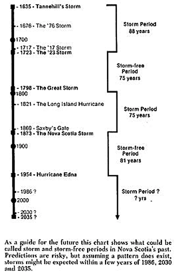
“Many of our forest stands in Nova Scotia are a result of past hurricanes. Mounds on the forest floor -the result of uprooted trees – indicate this. The age of trees growing on these mounds give a good indication of when the storm occurred. These stand ages compare well with the written records of past storms…”
Dyer (1929-2004) was perhaps the first to highlight and describe the pits and mounds of NS and to put together a related history of storms in NS. His diagram (at right) was a bit prophetic, forecasting our current period to be one of a relatively high frequency intense storms.
Forest structure more important than topography in determining windthrow during Hurricane Juan in Canada’s Acadian Forest
Anthony R.Taylor et al., 2019. Forest Ecology and Management Volume 434, 28 February 2019, Pages 255-263
Wind is an important driver of forest dynamics in eastern Canada, but knowledge of variables that predispose forest stands to windthrow remains unclear. This is of particular concern as climate change is expected to alter the frequency of strong wind events that affect eastern Canada. In this study, we used widescale forest survey data from Nova Scotia, Canada, of wind damage caused by Hurricane Juan, to investigate variables that influence stand vulnerability to windthrow. Juan made landfall as a category SS2 hurricane with sustained winds of 158 km/h and damaged over 600,000 ha of forest. The damage zone was surveyed using aerial photography and satellite imagery, delineated according to level of wind damage, and digitized as a 15 × 15 m resolution spatial raster layer. We selected a random sample of 50,000 cells classified as intact forest and 50,000 cells classified as stand-replacing windthrow from the raster layer and used boosted regression tree analysis to explore the influence of various meteorological, topographic, soil, and forest structural variables on the occurrence of windthrow. Wind speed and forest structure, specifically stand height and species composition, were most influential in determining windthrow. Sustained winds of at least 95 km/h or gusts of 130 km/h caused >50% probability of windthrow. Taller stands were most vulnerable, especially those dominated by spruce (Picea spp.) and balsam fir (Abies balsamea), whereas higher hardwood and pine abundance reduced windthrow. Interestingly, topographical exposure (Topex) ranked low in overall influence; however, a clear relationship between increased exposure and windthrow was observed. Contrary to expectations, mesic soils were most vulnerable to windthrow.
If an Old Growth stand in Nova Scotia blows down, is it still Old Growth?
Post on NSFN, Dec 4, 2019. My answer, Yes, if the blowdown is not removed (e.g. as a salvage harvest). Also view Estimating retention benchmarks for salvage logging to protect biodiversity by Simon Thorn et al., 2020 in Nature Communications – Thx to a N.R., a reader of this blog, for telling me about it; she sent a link with this question, “Do we do salvage logging in N.S.?” (Answer: yes, a lot).
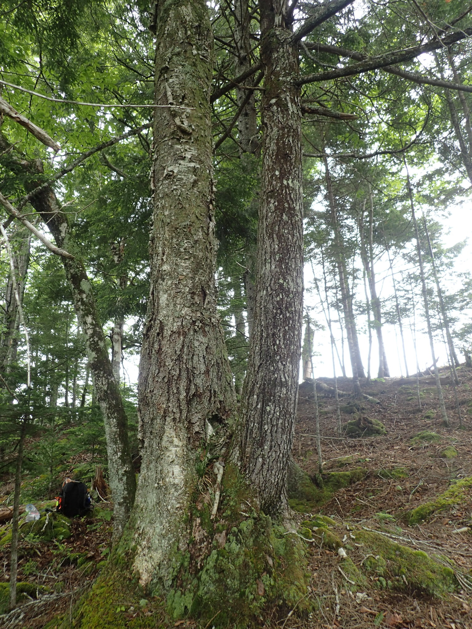
Yellow birch and eastern hemlock on a mound – the “Acadian Forest Love Affair”. It is situated in an unharvested, sloping riparian buffer area amidst a clearcut.
Click on image for larger version.
Thanks for sensitive management of an old forest in Nova Scotia
Post on NSFN, Oct 8, 2018. I visit an “overmature” forest in central NS and find many “pits and mounds”
Acadian Forest Love Affair
by David P (Jan 26, 2018) on sandylakebedford.ca. The physical intimacy of yellow birch and hemlock often observed on mounds in old forests is more than a coincidence.
Was this Woodlot once Farmland? Pit and Mound Formation will tell you
by Mike & Debbie Hickey in their From the Woodlot video series, N.B. Posted May 5, 2020. Nice description of a recent windfall, and showing an area of pits and mounds in their woodlot which they contrast with flat topography over most of the area.
Uneven Ground
Bt Akiva Silver, Chelsea Green Publishing, 2019. “An excerpt from my book Trees of Power published by Chelsea Green” It begins: “Here in upstate NY there are hills everywhere but the ground upon them is flat. The fields of our hillsides are easily mowed and grazed. They were smoothed out a long time ago when they were first cleared and plowed. It did not always look like neat rolling hills here. Ancient hardwood forests created a ground so uneven, textured, and three dimensional, that it resembled mogul ski runs. These types of forest floors still exist today on the steepest hillsides that have been woods for centuries. Walking in an old forest around here is more like climbing up and down pits and mounds of soil than strolling down a trail. The topography is so intricate that one hillside is actually made up of thousands of micro hills and valleys.”