
Are there links between extensive clearcutting near headwaters and increased flooding downstream? Bev Wigney thinks so.
Click on image for larger version
——
Way back in late November, BC learned about what one-would-think-would-be-an-obvious-link-between-extensive-clearcutting-and-flooding the hard way.
It seems equally obvious that such links would apply to NS. Bob Bancroft has been talking about our “Broken Rivers’ for years but what do we hear about it from DNR/L&F/NRR?
Bev Wigney, looking out her back door at a raging stream fed by waters emanating from the south mountain in Annapolis Co. and at recent Crown land harvest proposals, thinks the link is pretty clear. She wrote yesterday:
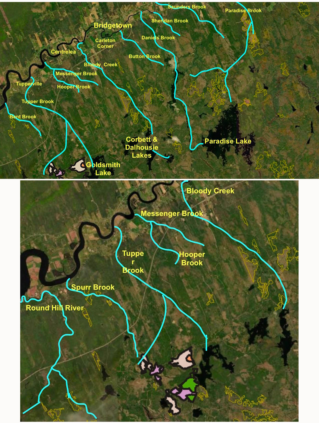
ANNAPOLIS PEOPLE:: This morning, I spent some time making these two maps for us to look at. As some will know, yesterday, the Dept. of Natural Resources and Renewables sent out the latest list of proposed (INTENDED) parcels for harvesting.
It’s a cluster of parcels that lie on the west side of Goldsmith Lake — you’ll see them on the map as green and purple patches outlined in black. What I wanted to comment on and discuss — is that ONCE AGAIN, this is MORE CUTTING of forests that are on the headwaters of several of the brooks that come down off the South Mountain, go under the 101 and then under the 201 – and then empty into the Annapolis River.
As most of you are aware, pretty much ALL of these brooks have, in the past few years, become subject to turning into RAGING TORRENTS after every rain that is anything more than a shower. The situation is rapidly worsening. Just a couple or so weeks ago, the Round Hill River got so messed up that it was outside of it banks and blasting over a neighbour’s lawn with a 2 foot standing wave. Totally nuts. That took days to subside. And, as just about everyone knows, Route 201 became impassable in SEVERAL places – basically almost EVERY SPOT where one of the brooks flows down from the South Mountain.Now SOME flooding is to be expected, but a LOT of people who have lived here much longer than me (like, people who have been here 30 to 50 years) said they’d never seen it like this before. So, what are we to make of this?
Well, take a look at these maps and see what’s up on top of the South Mountain — at the bottom of these maps. For your convenience, I’ve drawn in the major brooks in blue all along the 201 from about Round Hill or Tupperville to around Paradise. What do you see up on those headwater areas? What do you think might be the CAUSE of all of the flooding down below? Do you think the DNRR should continue handing out more parcels of forest to be chopped down on the headwaters above our roads, houses and farms?
Also posted on social media yesterday (Mar 15, 2022) by R.R:
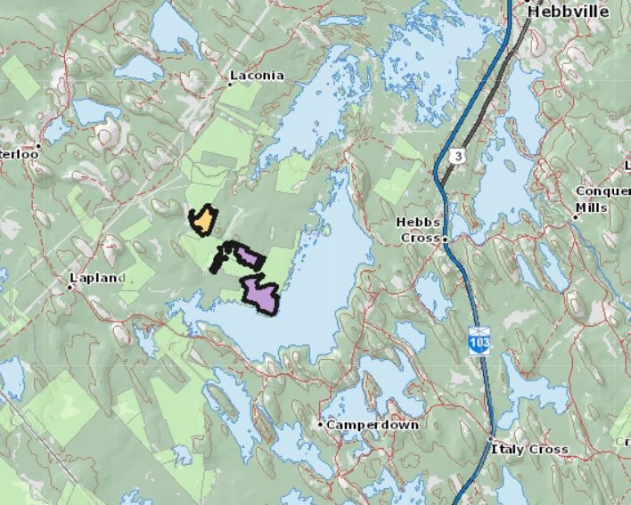
Here is a proposed harvest plan from WESTFOR. This is located in the Town of Bridgewater Watershed. The watershed consists of 3 large lakes and this lake system is the only known habitat on the PLANET for the endangered Atlantic Whitefish. How can this be possible that Natural Resources and Renewables would even consider harvesting any forest in this watershed ?
Makes one wonder.
| UPDATE mar 16 10 pm from Geoge Buranyi: WestFor and the Department of Natural Resources and Renewables demonstrate a complete and utter disregard for common sense in a decision to propose a 100 hectare harvest off Minamkeak Lake which is part of the Bridgewater water supply and home to the planets only whitefish population. Please repost widely. Cue the video to minute 8 where Paul Withers does an excellent report on the proposed WestFor cut off Minamkeak Lake and the threat to the planets only whitefish: view CBC Also: Loggers want to move into home of critically endangered Atlantic Whitefish Paul Withers · CBC News · Posted: Mar 17, 2022 |
An extensive search failed to reveal any cautions about possible impacts of clearcutting on downstream flooding on the NRR website. Could it be that this possibility has never been discussed at The Bunker?
I did manage to find otherwise this very relevant paper by researchers in Department of Plant, Food and Environmental Science, Faculty of Agriculture, Dalhousie University, Halifax, Canada & Department of Applied Mathematics, University of Manitoba, Winnipeg, Canada:
Modeling Reforestation’s Role in Climate-Proofing Watersheds from Flooding and Soil Erosion
Robert L. France et al., 2019 in American Journal of Climate ChangeAbstract (bolding inserted)
The mitigation potential of reforestation for offsetting the deleterious effects of increased flooding and soil erosion projected to occur in Atlantic Canada through future climate change was investigated. Modelling determined a strong but non-linear relationship between extent of vegetative cover and runoff volume and discharge rate for a Nova Scotian watershed, suggesting that reforestation will reduce, but not completely prevent, flooding. Predicted erosion rates were found to be progressively reduced in relation to the extent of upland reforestation. Of three scenarios examined in which 60%, 65%, and 85% of the entire watershed are randomly reforested, only the latter would reduce the elevated erosion expected to occur through climate change back to present-day existing levels. Additional modelling revealed that comparable mitigation of soil erosion can ensue through implementation of 70 m streamside buffer strips, which would only take up 19% of the total surface area. Prioritizing riparian zones for reforestation will therefore subsume less of the overall productive land area and therefore enact a less severe socio-economic impact on agriculture and forestry.
Clearcutting is cited as a factor in the degradation of the watershed modelled in the paper.
What would it take to adopt a minimum of 70 m streamside buffer strips in Nova Scotia? Amongst the recommendations of Prof Lahey that L&F/NRR have evidently not even begun to address was this:
25. The efficacy and adequacy of a 20 metre riparian zone that is only varied on the basis of slope conditions, currently required by the Wildlife Habitat and Watercourse Protection Regulations, should be independently studied with a view to determining (a) if it should be changed and (b) how it should be changed to better address the ecological rationale for riparian buffer zones.
See also conclusions 67, 68 pp30 to 31 in Ind Rev.
Why am I doubtful that any meaningful action on “this file” will happen any time soon?
SOME RELATED LINKS
British Columbia
– B.C. Flood Devastation Linked to Logging Practices ‘Without Question’, Experts Warn
In www.theenergymix.com/ Nov 23, 2021
– Connecting the dots between B.C.’s floods, landslides and the clearcut logging of old forests
By Judith Lavoie in The Narwhal, Nov 17, 2021:
–We can’t ignore the role deforestation plays in triggering devastating floods
P K. contributed to Globe and Mail, Nov 19, 2021:
–Over-exploitation of BC forests is flooding the province with physical chaos and human misery
By David Broadland in Focus on Victoria Nov 18, 2021 “Climate change helped transport the water from there to here, but the extent of the damage done is mainly the responsibility of BC’s out-of-control logging industry. ”
-Grand Forks flooding victims file class-action lawsuit against B.C. government, forestry companies
Ben Parfitt in The Narwhal Sep 14, 2020 “Excessive logging in British Columbia interior…”
Officials, experts warn logging in BC could worsen spring flooding
by Lyle Adriano In https://www.insurancebusinessmag.com/ 06 Jan 2020
New Brunswick
– Of forests and floods: Devastatingly high water raises clearcut questions
Shane Fowler for CBC News Jun 18, 2018: “Some researchers say clear-cutting can boost the severity of floods, such as the one province [New Brunswick] just suffered.”
Also: Did clear-cutting contribute to this year’s record flooding?
Information Morning – Fredericton June 18, 2018 12min/56 secs
Bob Bancroft on “Broken Rivers”
– Mending Nova Scotia’s broken rivers
Bob Bancroft for Nova Scotia Naturally column in the Chronicle Herald Nov 25, 2012
– 2001 at NS Legislature Standing Committee on Resources
Large clearcuts create drastic ground level climate changes that few forest-dwelling wildlife species can tolerate. Shady, moist, comparatively cool environments under forests are suddenly open to direct sunlight, higher air temperatures and the drying effects of winds.
Rainfall is absorbed by leaves, needles, tree roots and damp soils. After clearcutting, heavy rains hit dry, hard ground that has often been compacted by heavy machinery. Runoff rushes over bare ground. Organics and nutrients leach from the upper soil layers and wash away. Instead of slow forest absorption then gradual release of water, clear cuts flush like toilets into brooks, streams and rivers, creating increased erosion. Stream banks, torn asunder by floods, topple trees that shaded the waterway. Soil carbon begins to migrate into the atmosphere.
Silt clogs spawning beds in stream channels, causing fish eggs to suffocate and die. After heavy rains repeatedly rip their way downstream, stream channels are left wide and shallow. Summer water levels become very low. Increased amounts of sunlight overheat the water, increasing evaporation and causing cold water species like salmon and trout to suffocate for lack of oxygen in the water. (For more information on how streams and rivers fall apart with poor land use, see Saltscapes Volume 1, No. 3, 2000, entitled “Cry Me a River”.)
Bob Bancroft in Clearcutting & wildlife don’t mix – Saltscapes Magazine
From the recent scientific lit
– Fifty years of runoff response to conversion of old-growth forest to planted forest in the H. J. Andrews Forest, Oregon, USA
Crampe et al, 2021 in Hydrological Processes “. Hydrologic processes altered by harvest of old-growth conifer forest more than 50 years ago (transpiration, interception, snowmelt, and flow routing) continued to modify streamflow, with no clear evidence of hydrologic recovery.”
– Evaluating the effects of timber harvest on hydrologically sensitive areas and hydrologic response
MengqiZhao et al., 2021 Journal of Hydrology
Highlights
• Timber harvest effects vary with changing topography, climate, and harvest regimes.
• Thinning on low runoff probability areas cut peak flow up to 40% from clearcutting.
• Logging in areas of high runoff probability led to higher peak flows.
• Harvest in low runoff probability areas caused large peak flow in snowmelt events.
• Timber harvest planning can be improved based on hydrological response analysis.
– Modeling Reforestation’s Role in Climate-Proofing Watersheds from Flooding and Soil Erosion
Robert L. France et al., 2019 in American Journal of Climate Change – NS watershed modelled, see above.