
A discovery by the Annapolis Co. Nova Scotia folks that harvesting on Crown lands proposed for harvest had, apparently, already begun, preceded by construction of some pretty massive roads including a 19 meter “Road to Nowhere”
-Update Dec 31, 2018: UPDATED: Voice in the wilderness – Citizens discover some proposed Annapolis County harvests may already be complete
Lawrence Powell In the Annapolis County Spectator
-Update Dec 31, 2018: Nova Scotia Crown land Harvest Plan Map Viewer folks made a mistake; no apology
Post NSFN
-Update Dec 30, 2018: On WWNS Discussion of the road
-UPDATE Dec 30, 2018: CORBETT–DALHOUSIE LAKES: FIFTH POST AND PROBABLY FINAL POST
-UPDATE Dec 29, p.m. : Letter sent to Premier Stephen McNeil, others
———-
 Six days ago, I wrote a post about Annapolis Co. Nova Scotia folks investigating more Crown land cuts
Now they have done some ground-truthing of a proposed Crown Land harvest of the “Dalhousie-Corbett Lakes parcels”. Their first venture took place on Boxing day, with a dozen plus participants, and there was a follow-up by a smaller group yesterday. What they have been seeing and thinking are given in four posts on Annapolis Royal & Area – Environment & Ecology (Facebook Public Group):
CORBETT – DALHOUSIE LAKES — FIRST POST
CORBETT – DALHOUSIE LAKES — SECOND POST
CORBETT — DALHOUSIE LAKES — THIRD POST
CORBETT–DALHOUSIE LAKES: FOURTH POST
They read like an enticing novel – with an upsetting plot: The discovery, apparently, that harvesting on Crown lands proposed for harvest had, apparently, already begun, preceded by construction of some pretty massive roads including the 19 meter “Road to Nowhere”.
From BW’s Fourth Post:
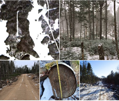
There is still plenty more to be said about the “proposed” harvest parcels that we visited on Boxing Day — out on the peninsula between Corbett and Dalhousie Lakes. Something that has come up since our visit was that a few of us started looking at some of the satellite mapping apps that let you examine a tract of land over a period of time. A couple of you provided maps that showed the “new” road that was constructed — near as we can tell — somewhere west of the boundary of the north parcel — so actually “within” the parcel. The road first “appears” on satellite maps in mid- July 2018. I’m posting one of the maps provided to me (thanks Sue!). Please note the very straight line going north-south down the peninsula. This map was made from a satellite view from December 2018.
Now, there’s something else to note — something that surprised us very much after our walk around the area on Boxing Day. Due to cold weather and time constraints, and difficult footing — we never continued southward to see what had taken place inside the “south parcel”. Well, once we saw the satellite maps, it was clear that there had been heavier harvesting down there — again, on a parcel that has just appeared on the “proposed” parcels sent to us in the notifications from the HPMV site. You can see that down at the bottom left of the peninsula — a sort of scratchy looking grey area. As you might suppose, this was a somewhat disturbing revelation.
So, today, braving the snow and cold, a couple of intrepid souls returned to the site and walked in to take a look around at what is now there — on that scratchy grey part of the map. I’ve included a photo that is fairly representative of what it looks like in there — NOW. It’s really nothing like what we found a bit further north — and if this were to be done to the “north parcel” with all of those large old hardwood and Red Spruce — well, that would be disturbing in the extreme. In this case, there was more softwood — a lot of young balsam fir, and there were larger Red Spruce which were logged off, and some hardwood. There is much less remaining standing than in the parcel to the north. So, there you have it. An area of “proposed” harvest – 18.9 hectares in size – that now looks like this. Based on satellite images, it’s been like this since early September. I guess it’s probably TOO LATE to bother making a submission to the HPMV before their SUBMISSION DEADLINE on January 19, 2019. What do you think?
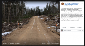
Now, about that road! Isn’t it something? A road leading toward the end of a peninsula. Let’s give it a name. I kind of like the sound of “Road-To-Nowhere”. It was measured today and the average width was roughly 19 meters — I believe that includes the surface and some of the shoulder area. I should be able to elaborate on those figures soon — so maybe watch for an edit to this post tomorrow. I’ve posted a photo of the road to give you a better look, but there were some photos in my second post. In fact, I’ll repost one of them to remind you of how long and wide it was. Well, let’s compare the “Road-To-Nowhere” with Neaves Road — the road that runs east -west in from Morse Road, crossing a bridge over the dam before continuing on past the north end of the “proposed” harvest parcels. Neaves Road is only 9 meters across. Go figure.
EDIT: I am now adding in the measurements and notes for observations of both Neaves Road (the main road that comes in off Morse Road to get into this area), and also the “Road-To-Nowhere” that turns south off of Neaves and goes down into the peninsula to access an 18.9 hectare parcel of softwood. There is a turnaround and area to pile logs at the south end. Based on the sizes stated for this two west side parcels, and the buffers and what remains of the forest on the east side (not part of this harvest), there might be a total of 100 hectares of forest on this whole peninsula. I should mention that this road has nowhere it can go to as there is a waterway area and a marshy area south of the peninsula, so this all it can ever be.
——–
MEASUREMENTS:ROAD-TO-NOWHERE: *4.9 m road base* (the built up flat portion)- and a *19.5 m cut width* (where trees have been cleared away along the sides of the road).
NEAVES ROAD: *5.3 m road base* (built portion)- and *9 m cut width*
NOTES ADDED TO THIS EDIT: So the striking thing is that while the built portion of each road was very similar, the cut swath was highly *exaggerated by roughly 10.5 meters or more*.
MY NOTE: Why? I have seen logging roads in Oregon and California where truly monster sized Redwood, Douglas Fir, Ponderosa Pine, and Sitka Spruce are brought out on huge trucks — often through really rugged terrain — and I have rarely seen roads cleared off to either side to this extent — except where there are switch-backs to get down from mountain passes or turn onto busy roadways. Even then, I doubt most were cleared this wide. Such wide clearances just provide more disturbed ground for invasive brush like (goddamned!) Glossy European Buckthorn or other plants. Okay, enough ranting. Back to the continuation of my original post.
——–So, this long, very wide “Road-To-Nowhere” was made through the north parcel of hardwood forest — which had to be cut down and kicked out of the way to make way for the road. Just by chance, I happened to notice a section of Birch log in the slash and debris from the road construction. I shot a photo of it while climbing over slash to go into the woods to photograph other trees. You’ll see my photo here. The section of log was 16 inches in diameter — the rest of it was gone but it looked like the remnants of what was probably a pretty nice tree at one time — nice and solid and not hollow inside. Yessir! Someone got a good Birch log when they were clearing the way for that road! I figure there were probably quite a number of other damned annoying logs that had to be gotten rid of to build the road. I wonder how many hectares that would be if you calculate the width and the length? Maybe some smarty-pants among you will be able to figure that out sometime.
Well, enough for tonight. I just wanted to post about these more recent findings that were based on examining satellite images and a bit more ground-truthing. Thanks to Donna and Randy for going back out on what turned out to be a very wet, slippery and treacherous day after it began to snow. Enjoy the photos. I will probably have another post ready sometime tomorrow. Stay tuned. In the meantime — SHARE — SHARE — SHARE — these posts! Thank you.
Some of the Comments:
KB: That was interesting, what a nice group you have in your county. They get paid for putting the roads in.. more road more money? The minister should respond to how his departments monitoring system did not pick up on the pre approval work. I was told all cuts would be monitored by dnr staff, (minister Hines) . They should then have records of all their site visits.
This was in contrast to a call to the local office at the time, I was told to contact Westfor as they had nothing to do with Forestry any more. The whole thing has been hard to figure out. What a mess…I have absolutely no idea how any of this works. To me, the whole thing is truly bizarre.SS: Wow I dare not write anything tonight. This is a sad tale of they do what they want and NO one is over seeing them at all.
KB: ou should hear some of the stories of how DNR was shut out of their own crown land, by locked gates after the first year of cutting got started..
ME: Is it legal to harvest crown land before a proposal has been approved?
BW: Well, there’s supposed to be this system where parcels go through a process of approvals. Part of the process is for them to be listed so that the public can make submissions if there is something that should be considered – like maybe a population of Species at Risk in that location — or that removing the forest could cause serious erosion in an unstable area, etc… Then there’s some other stage as well. I don’t really know what happens in such a situation. Obviously, it’s never supposed to happen. Now we have to wonder how often it actually does happen. 🙁 . …And, now we’re heard from a couple of locals that there are Blandings Turtles in around that location — not yet confirmed, of course, but that would have to be considered in the approval process — which never happened.

Eyes on the ground help
To be continued, I am sure in more places than one in Nova Scotia.
Thx Thx Thx Annapolis Royal & Area – Environment & Ecology for being our Eyes on the Ground
——–
Some Comments on WWNS:
AF: i did not see any hardwood trees that would make a sawlog all firewood low grade hardwood and lots of overmuture spruce…this road is logging road size log trucks are a standard size so are loging roads.anything smaller would not be usaable the neavs road seems narower but only becous the ditch and shouldr have had time to grow back…westfor has to much power and the top level of dnr is not working for the people but the work done on this lot was exactly what the layhe review was calling for…i have been told by a reiliable sours that this cut appered on the dnr list of cuts for aproval befor this road was put in
BW: Thanks, AF. It’s good to have some input. Quite a few who went out for the walk felt the road was pretty large, especially as it can only ever service an area of what would probably amount to 100 hectares (at the most, I think), and it cannot be made into a through road as there is a marshy expanse on the other side of a small waterway. I can see the need for a turnaround and a place to stack logs. As for having been on the DNR list, we’ll have to wait on that. It appeared on the Dec. 10th with another proposed harvest over near Allen Lakes — so what are we to make of that? Maybe DNR needs to design a better system of describing parcels. The way it is right now, all we see is what gets put up on the HPMV — and that isn’t much at all.
BW: By the way, yes, I think in particular, the south parcel is probably done as it should be. I think the north parcel probably was (or will be?) — we’re not sure what is left to do, so kind of hard to make that call as yet. That’s not what concerns us the most. It’s the system of notification and that there is really no point in putting these proposed harvests on the HPMV for us to submit comments if they aren’t even considered anyhow. Really, why create the illusion that any of us actually has any say in things. It would be better to set up a different system — maybe with a county forest group who meet to consider proposed tracts very early on in the approval process so that everyone’s thoughts and ideas for management of a property are taken into consideration at that stage. To just have these proposed harvests suddenly posted on a website that most of the people in a county can’t even figure out how to use — and with a 40 day comment period — it’s just asking for trouble as far as making people frustrated and angry.
BW: I should also mention that we’ve heard that a tract that many people in this county worked hard to have removed from the harvests just a short few years ago, may be getting listed again — there is activity happening around it. See, this is the kind of thing that makes people in a community extremely angry — because the only notice we will probably have (if this comes to pass) is that the parcel will suddenly show up on the HPMV notification list once more and we’ll all have to fight the damned thing again. This isn’t fair to the residents to keep pulling this on us.
DGP: Thanks for the clarification Adam. This is not a criticism of your comment: I assume they could use smaller equipment that could function on narrower roads, cause less compaction, and have less impact on future productivity (correct, AF?) but that would employ more people and cost more and we need to provide cheap pulp to China so they can make cheap toilet paper and other products and export it back to us so that our minimally paid workers can afford it and those not minimally paid still have lots of $ to buy far more than they need so we can keep the planet warm.
AF: much smaller equipment could be used in the woods but roads are a must have eaven if useing horses
BRL: What I’ve noticed when driving around is that they cut and leave large hardwood on the ground. They drop it to access the softwood. Maybe it depends on the company who is working the area but I have seen so much waste it makes you sick. All the fire roads are looking exactly the same with their big roads in Kings County as well.
BW: To me, the weirdest part is that I’ve seen much narrower logging roads and this one is just a straight shot in to a turnaround. There are only — at the very most about 100 hectares of available forest (in total) on that peninsula. I look at that road and wonder what that cost to build — for what — to harvest 20 hectares of spruce and balsam — and cut down a bunch of hardwood forest to get to it — although I assume that at least went for firewood. It’s not like this is some complicated, hilly, winding road. I’ve been in logging roads in the California Redwoods and Oregon Siskiyous where they are hauling out truly big logs on roads not as fixed up as this one. This one can’t even go somewhere as there is water and marsh on the other side of the south parcel. I’m sorry, but with the condition of other public roads in this area that could use some fixing up, I’m just kind of amazed that a road of that type was built to get in to harvest 19 hectares of softwood.
DC: I’ve been noticing for some time that extraction roads seem to get wider when the timber is more valuable. I am not sure whether we have a specified minimum-max width for Crown logging roads, but it is time to put some in place if we don’t have them. This short dead-end road does not need to be wide to meet its intended purpose, but it is a FULL 10.5 m wider than the Neaves Road (a main artery road that connects Morse Rod to many km of cutover). The width of harvest road: 4.9 m road base (the built up flat portion)- 19.5 m cut width (ginormous). Compared to
Road width- Neaves Rd: 5.3 m road base (built portion)- 9 m cut width. If a 9 m cut width is good enough for the MAIN road that all trucks must pass over, the small deadend rd on the peninsula does not need to be wider than this.
BW: Agree. As I wrote below, I have been in on logging roads in California and the Siskiyous in Oregon – where they have very large trucks hauling wood that makes ours look like toothpicks, and by those standards, the amount of wood removed as clearance here looks pretty grandiose. I can fully understand cutting back more forest at a bend, or a junction where a truck has to clear beyond the edge of the road — in California and Oregon, you see that on the switchbacks where they must ascend and descend through forest on mountain passes or into canyons on very steep angles. But on the straight stretches, it’s sort of done like a regular road — nothing special.
AF: no one makes roads biger just for fun the roads are ditched and the matreals from the ditch are used to billed the road the neavese road would have measered the same as this one except it has had time to grow back along the ditch and shoulders
Manage
DC to AF The road base is roughly similar to elsewhere. so you are correct. But the point is that the CUT width is wider than it needed to be, a full 10.5 m of cut trees wider, and going through a nice dry piece of land among trees that have stood the test of time. It’s ridiculous. The wider the cut swath, the more blowdown incurred. But I get it, there are folks we need to defend-buddies that built the road, etc. No one wants to go after the little contractor. The gov’t oversees all this and that’s where the blame lies.
———–
UPDATE, From Healthy Forest Coalition (Facebook Public Group) post: Letter sent to Premier and others
ML: Faith in the process with which the Department of Lands and Forestry manages our public forests has taken another blow over the holidays:
Parcels AP068637B and D – Corbett Lake (Annapolis County) – appear to have been harvested while the public consultation period is still in effect. These parcels are supposed to be open for comment until Jan. 19, 2019 but it looks like they have already been harvested.
Regardless of how this occurred, be it an honest mistake or an egregious and complete disregard of the already-limited public consultation process, this is bad. Real bad.
I said it just a few weeks ago (when what was likely to be some of the oldest forests in the Maritimes was up for harvest) and I’ll say it again: If you are waiting to see concrete evidence that the systems on which we depend to manage our public forests need to change, this is it. Broad changes within LAF are needed and they can’t seem to reform themselves.
The following letter, composed by Donna Crossland and Bev Wigney was sent to Premier Stephen McNeil, Minister of Lands and Forestry – Iain Rankin, Warden of Annapolis County – Timothy Habinski, and Gregory Heming –
Chairman Forestry Advisory Committee for Annapolis County Council:“December 27, 2018
“Out of courtesy, we inform you of a serious breach of government process that has occurred with regards to forest harvests on the peninsula between Dalhousie and Corbett lakes on Neaves Road near West Dalhousie (AP068637B & D). Media reporting is already in progress and social media is circulating this widely.
“On Boxing Day, a group of 18 concerned citizens from a range of backgrounds and locations within Annapolis County joined us on a field reconnaissance to the proposed harvest parcels mentioned above (Figures 1 a, b). The comment period remains open until January 19 th, 2019. To our surprise, a wide and well-constructed access road has already been built within the last 3-4 months, slicing much of natural forest on this peninsula in half (Figs. 2 and 3). Access roads are part and parcel of any proposed harvest and cannot be considered separately, nor pre-empt public process. The road incurred the removal of a substantial volume of public forest, owing to its exceedingly wide width (wider than the Neaves road, Figs 3 and 4); that itself is a waste of public funds.
“Further exploration revealed that a substantial portion of the uniform shelterwood had already taken place (Fig. 4). There are few intact public forests remaining in Annapolis County and this natural patch is of public interest, being located on a canoe route and holding ecological significance with old growth legacy trees of yellow birch, sugar maple and other late successional species dominating of various ages.
“Harvesting and road construction prior to public opportunity to participate in the process demonstrates that the government process is broken, and it further validates why we cannot trust the Department of Lands and Forestry (LAF). We have repeatedly requested that a serious re-organization in personnel is urgently required to enable this department to carry out true reform and better forestry. The public knows that LAF is incapable of changing its practices and that higher leadership is essential. We urge you to take forestry reform more seriously, and please wisely choose this violation as ‘just cause’ to immediately clean up LAF and its conflicts of interest, as an essential step to implementing Dr Lahey’s forestry recommendations and restoring public confidence.
“In the process of adopting the TRIAD approach to forestry, it is worthy of note that the uniform shelterwood prescribed for this land would not constitute ecological forestry as it ultimately results in a complete overstory removal (in some respects it’s worse than the recently adopted interim clearcut retention measures). The resultant clearcut (as per National Forestry Database definition) is not only unacceptable, but contributes NO FINANCIAL benefits for Annapolis County, while we pay through our local ecology for both the cut and road construction as well incur expensive damage on our paved roads. The third leg of the TRIAD, intensive forestry is already full and over-flowing, as witnessed in Fig. 5. We need true ecological forestry in Annapolis County now and waiting another year for better forestry by LAF will incur incalculable losses. Their interim measures are inadequate. Public unrest grows daily.“We are available if you would like to further discuss our concerns.”
Update Dec 30, 2018: On WWNS Discussion of the road
WWNS: From the W&WNS ‘Grapevine’:
“Seè all the controversy over the road by Corbett lake , and I must say that the people doing the complaining are either grasping at straws or are completely unaware of any construction or road building and really should get some insight and facts before posting.
Here are some facts about road building. Any road right of way cut on crown has a width that can be cut out , the area that is cut allows room for excavators and dozers to dig fill out for road base and allows room for stumps and rocks to be placed off the side and buried as much as possible . If anyone knew anything about road building they would see that same practice taking place on main highways being built for the province . By comparing the old road to new has no bearing. If these so called experts would walk off the sides of old roads they would find old burrow pits where fill was dug out and used to build road ( walk along old DOT roads or old wood roads ) which means they were cut as wide then as today The width of the right of way is needed to get the base of the road. Once that is accomplished that area off the side is allowed to grow in and only bushes then need to be trimmed ( unless trailers get longer then some turns need to be widened) This is a common practice on any road construction and used on woods roads or on major 100 series highways . As for a little wider in places , machinery comes from the woods and drive in ditches and piles out to road so trucks can pickup wood.This is done to save destroying the new road from machinery; also a safety issue for the public as machine operators cannot see vehicles or off road vehicles or pedestrians that may decide to pass or go around a machine that is unloading wood . If a piece of wood falls off or comes out of clam and falls then someone could be seriously hurt or killed
But let’s face facts , roads will always be built in the province whether woods roads or major highways , so if you want them cut only to a certain width that prohibits construction, than be prepared to see quarry’s popping up everywhere , dumpsites for rocks and boulders and gravel trucks hauling day and night . Also any old road right of way I have seen it only takes a awhile for it to grow up and I hear the general public complaining everyday about the state of our roads and how the bushes need to be cut along the edge.”
AF: if your against forestry roads you are against sustainable forestry. even horse logers need roads the size of this one. if sustainabe forestry is not suported we are wide open to the government and big mills explotaion.NS needs rural jobs there could be many green jobs in a well managed small scale forestry oporaiton. if you want to stop the harvesters takeing so fast you need to suport chainsaw loggers
SR: Why then was the road built exactly, according to this “expert”? What project is it intended for on crown land prior to any public consultation or approval? What would have and should have remained undisturbed forest is now a wide gash through a questionable aged forest, and with its wide berth and complete eradication of stumps, we do not truly know what damage was done to a possibly protected forest. On our lands.
MH: I guess we know why name was withheld.. as they have a stake in the operation..how much do you want to bet?
SS: Well, I don’t have exacts either but that was approximately 5 acres of forest removed for that road that goes NO WHERE. Yes ok it makes Corbett lake more accessible from more sides but Corbett Lake was already accessible just a little further up Neaves Road. So if you wanted to go onto the lake and then off and into the forest it was already VERY accessible to do so.
SR: In order for a private operation to have created that road, it would need departmental approval or an order in council. The only OIC I found for Annapolis County was in West Paradise.
WWNS to MH: People should not make assumptions. The person who stepped forward has many years forestry experience (never said they are an “expert” as stated elsewhere ) and depends upon forestry for their livelihood. This person is far down the pecking order in terms of $$ earned. But they know what they are talking about. How or why the road was put where it is by hook or crook was not part of the discussion. The fact this individual contributed to W&WNS is muchly appreciated. Just wish more in the industry would come forward but this is such an emotionally charged topic most are treated as pariahs. The stories they could tell if allowed without fear of repercussions would blow the lid off but they need to eat. True there is a lot of bad stuff going on within forestry but there are also others doing good work. Just sayin’.
SR: The expert comment applies to the road building lesson we have all been given here, by someone who feels we all need to know. The inferences that this is how roads are supposed to be built, misses the mark on why a road is supposed to be built. It is, as has been stated in other posts, a road to nowhere, unless the builder knows something the rest of the world has never been informed of. The statement does speak about machinery and log drops, so it is obviously of the writers opinion this is a logging road. It is unlike any other logging road I have seen pictures of elsewhere in the province though. In reading the statement, it gives me the feeling it was written by someone who built the road, due its defensive tone. When choosing to share your opinion, it should be expected that people will debate you.
KM to WWNS: why allow these anonymous posts, if the person is sure of what they say let them put their name to it. otherwise you are spreading gossip.
WWNS: Is this any different than a news report based upon sources requesting anonymity? NO!!! W&WNS knows the identity of many sources but doesn’t blab their names. Otherwise it turns in to a witch hunt which appears to be happening here. People should stay focused on why this area was cut before it was approved in the latest harvest map This conversation is over. Give it up. Move on. Someone in gov’t has screwed up. Go after them.
KB: This comment regarding people coming forward is very true. If you are ever going to sell tonne of wood in Western NS again you would not dare breath on this page… the small producer is almost out of the picture in this system, the fiber supply is flowing to the mills the way they planned it when they set up the system they are presently using, call them and see if they will take a load of studwood . The chainsaws are quiet, the processors are running, very people are working in the woods, almost none compared to 10 years ago, that is one real reason many are not interested, out of sight out of mind… Golden Rule of Forestry work… If you cant sell it dont cut it..
CD: The point is, the road should not have been constructed in the first place before the clear cut was passed. If the clear cut plans are abandoned, the road has no point, and the forest cut down to make the road has been destroyed for no reason.
ZK: Char right because roads are only for clearcuts. 🤦🏻♂️
CD: There is a very strong possibility that this was all that this particular road was constructed for. And we are talking about this specific road, not roads in general.
AF: this road was constrocted just as it should be its not the falt of the road. westfor must be driven from sw nova but the ignorance around this is playing right into there hands
RL: A good majority of people wouldn’t be able to enjoy the backcountry without road access, to a canoe launch, a favourite fishing hole, picnic beach… people discover new scenic favourite spots because of a forestry built road… I know there are going to be comments about there being nothing left to look at it because there isn’t a tree left in sight and so forth but it’s simply not true. Forest roads that are upkept are great for all enthusiasts, ATV’s, hunters, fisherman, wild foragers, researchers, etc..
GH: Then there goes the quality fishing, areas that once took time and a good deal of effort to reach have been disappearing for decades.One way or another it’s about consumer convenience.
DS: It is precisely the ease that more people have in getting to the back country that is resulting in such strain on our wildlife. When there were only a small number of people willing to take on the hardship of travel to get in there the animals and fish had a nursery to keep their numbers up . With the advent of four wheelers and the cutting of roads everywhere there is no haven any longer and it has adversly affected the ecology of hte province.
GH: Well the commentary is just about road building facts and if the picture depicts the actual road there’s not much there.
SL: Great to know how to construct a road off a main highway, but it’s still very coincidental that this one just happens to be in an area where a clear cut is being planned, but not yet approved.
SS: Also very sad that such a road is better than a municipal road that leads into. They build roads like that in there but the trucks all come out past my house on a municipal road that is left to be destroyed by the same trucks that use these lovely roads. If they are going to do this then darn they should fix the roads up that lead into them…Also I see new culverts being carted in back my way all the time but when it comes to municipal roads they have to have a YES from TIR and Environment to replace a culvert but so many are being put into logging roads.
KM: Grape vine? people are now afraid and reluctant to connect their names with their comments? interesting.
WWNS: This just in from Grapevine: Please keep in mind this person is only explaining the rationale behind road building – in general. The reason it was built here before apparent approval to cut is another matter altogether to be taken up with the powers that be. Personally W&WNS appreciates the input. “The reason forest roads are constructed is to be able to manage the forest lands today and for later treatments.
A common practice for any type of forestry operation , either a clearcut , selection harvest , commercial thinning etc is the normal forwarding distance to extract wood products is 500-600 metres , anything over that distance than the cost to forward products to roadside where they can be picked up increases maybe as much as $5.00 a tonne or more .
I would assume these blocks were cruised ahead of time to see how many tonnes would be extracted depending on treatment .
I would also assume that the distance of road needed to make extraction around that 500 metres was calculated in and in most cases it is cheaper to build road than pay extra for forwarding.
Plus if they haul every load of wood out that distance then in most cases as much damage would be done to soil, and tree roots than as much as building new road
Ask any private woodlot owner , and they all build roads to access their woodlot
Let’s talk dollars as wood is only worth so much money roadside.
I had a lot harvested years ago and got prices from local contractors , ( some wanted to build 200 metres of road some did not ) . Harvesting cost was the same , the only difference was the ones that did not want to build road wanted an extra $3.00 a tonne for forwarding . I went with contractor to build road as it left me more money. I had approximately 5000 tonnes harvested; built the 200 metres of road for $3200.00 . By paying the other contractor the extra $ 3.00 a tonne it would have cost me close to $15,000.00 so I gained $11,800.00 by building road.
Folks , business is business and at end of day forest products of any type are only worth so much , so I am sure any woodlot owner in the province wants to make as much as possible for what they harvest .
Roads cut down operational expenses and puts more money in woodlot owners pockets , plus it can be used for years to come . Crown land is no different as once these roads are built to save forwarding cost today it makes it beneficial for anything that is done in that area in the future .
We have always said that in order for any business or industry to survive in the future infrastructure is the most important part . So I see this road as cost savings today and infrastructure that is in place for the future .
Ask any woodlot owner the benefits of having wood roads on their property , most would say best investment they ever made”
DGP to WWNS: I guess what we need in the end is a full accounting for this road. When was it was built, why, who paid for it? What was the total cost? Who set the specifications and on what basis? What permissions had to be obtained? What assumptions were made about approval of harvests if it was built to facilitate removal of wood? If it’s all a tempest in a teapot, OK, we all learn; if not, we all learn as well.
DW to DGP: One of the great current problems is the maze of red tape which must be negotiated before action can be taken. Is there really need for more ? I presume there was some woodland on either side of this road. So what is all the fuss about ? Some 40 years ago the government was prepared to cover much of the cost of building an extraction road which served more than about 200 (?) acres of woodland and that road which I happen to know about is still in good shape and will be 40 or 80 years hence. Moving construction equipment and crews around helter skelter to build roads just before widely scattered areas were to be approved for cutting would be very inefficient. And what would be the possible advantage ? It would be prudent if those who managed crown land were to build roads for which an eventual need was foreseen while construction equipment was in the area——. The need for access roads to manage and protect woodland is surely obvious so what comes next ? Complaints that when the tree fell the sound was not recorded for posterity ?
DGP to DW: The problem is the relationship of the recently built road to approval of Crown land harvests in the area, as the first proposals have only just been posted. So the road seems to have been built before harvests were proposed and vetted with public feedback. Perhaps there is no problem. But it all needs to be explained, including the dollars and cents. Supposedly industry identifies Crown lands it would like to harvest, then it all goes through a PTA/approval process etc..If there are longer term plans for a larger area than the proposed cut on specific parcels, surely that plan should be evaluated. Perhaps it is, but that aspect is not shared with the public which is a legitimate stakeholder. There is an overall lack of landscape level planning by NSDNR which also part of the problem, and should enter into harvest decisions.