But, what seemed positive news turned out to contain some very sour grapes
(New content added 8: 15 pm)
UPDATE May 3, 2019
Bev Wigney requests “a map showing all of the parcels in Annapolis County that were granted approval for harvest before the HPMV was established…all those that were approved before the HPMV and that are either going to be harvested by whoever licensed them, or that will be or have been turned over to Westfor without going through the current HPMV process with its public consultation period. View post on Annapolis Royal & Area – Environment & Ecology (public Facebook group). Response, within a few hours: “Thank you for your comment. The department will discuss this topic and get back to you.”…and a few hours after that: “We are searching for the old pdf maps that showed proposed harvest areas before the HPMV was put online in April 2016 so that we can restore that webpage. We will notify you when we have that information.”
UPDATE May 2, 2019: A Petition has been launched to stop logging in the Corbett-Dalhousie Lake area. From the Petition:
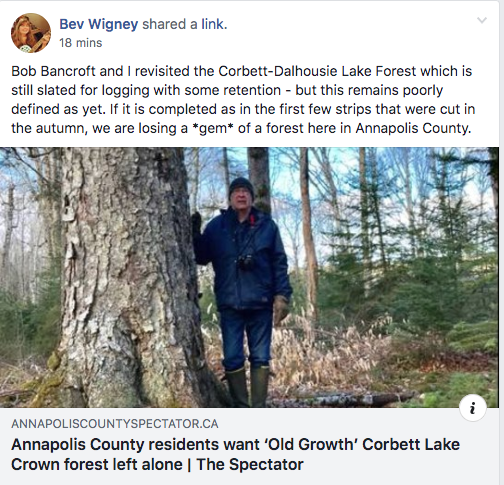
The Minister of the Nova Scotia Department of Lands and Forestry has given his approval to the continued destruction of the forests on the peninsula between Corbett and Dalhousie Lakes in Annapolis County. Much of this is “old forest” with “super canopy trees” – many of which are more than 8 feet in circumference. Much of it is shade tolerant forest featuring important tree species such as Yellow Birch, Sugar Maple, and Red Spruce — all of which are long-lived species typical of what was once the pride of the renowned Acadian forests of Nova Scotia before they were all but reduced to a pathetic shadow of their past.
….A few strips of this forest have already been chopped down (see photo). This was done last autumn before work ceased for the winter. It is a scene of destruction. The best of the trees in these strips were removed, leaving misshapen and multi-trunked survivors standing – trees that are *SUPPOSED* to be “overstory”
…. Now the plan is to do the same to the remaining forest…
——–
Received today in an e-mail to those who Sign up for map-update notification (accessed via via DNR › Forestry › Harvest Operation Maps):
 Effective May 6, any new comments received through the Harvest Plan Map Viewer (HPMV) concerning proposed harvest plans on Crown land will be addressed directly by staff at the Department of Lands and Forestry. This change is being made in response to public feedback. Previously, the licensee would have been the direct contact for most comments, although all comments were monitored by department staff. Licensees will still be aware of the comments and will be consulted on responses as needed, including operational and local issues such as harvest timing, road use and recreational activities. Effective May 6, any new comments received through the Harvest Plan Map Viewer (HPMV) concerning proposed harvest plans on Crown land will be addressed directly by staff at the Department of Lands and Forestry. This change is being made in response to public feedback. Previously, the licensee would have been the direct contact for most comments, although all comments were monitored by department staff. Licensees will still be aware of the comments and will be consulted on responses as needed, including operational and local issues such as harvest timing, road use and recreational activities.
There have been changes to harvest prescriptions for several proposed sites in the South Mountain Ecodistrict. The changes are based on a combination of public comments, additional site information, and staff reviews that align with the recommendations of the Independent Review of Forest Practices. Two sites are not approved for harvest at this time: AP068677 Tupperville – 1 stand 19.85 hectares planned as a systematic patch shelterwood partial harvest For most sites, the harvest and silviculture prescriptions shift towards a focus on uneven-aged management. New harvest prescriptions are as follows:
All these sites can be located in the archive section of the HPMV except for AP157007 (Neeves Road) which was actually originally posted as an 85-hectare partial harvest in November 2014. At that time pdf maps were being posted on the department website. The system was upgraded with the move to the HPMV in April 2016. Figure 1 below from that pdf map shows the parcel number 409 and a partial harvest prescription. No public comments were received on that proposed harvest. This parcel was assigned to a sawmill who had a short-term licence, but the harvest was not carried out. 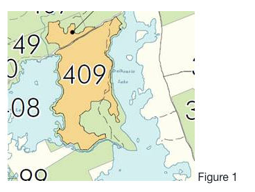 Figure 1 Once the individual licences to mills were replaced with a short-term licence to Westfor, 36.9 hectares of the original parcel was re-submitted for approval as a partial harvest and approved by Minister Rankin on April 23, 2019 as block number AP157007 (Figure 2 below). 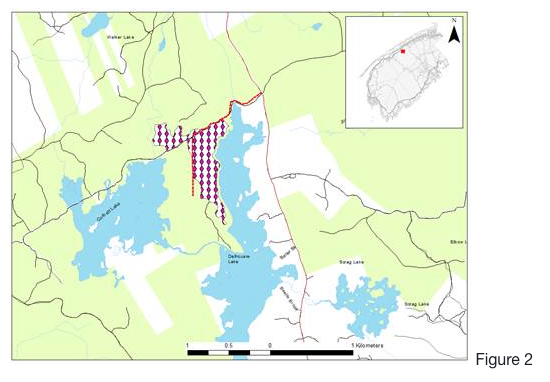 Figure 2
|
Thx to L&F/Forestry Maps/Minister Rankin for responding to these concerns.
It appears Minister Rankin was particularly bothered by this one, making a related post on Social Media at 12:30 a.m. on Sunday April 28, 2019. (View also Post on NSFN, Apr 27, 2019)
Thx to Bev Wigney (Annapolis Royal & Area – Environment & Ecology), Shelly Hipson (Stop Spraying & Clear-Cutting In Nova Scotia) and others for raising these particular concerns directly with L&F as well as publicly and for persisting.
——————-
Later on, May 1, 2019…The sour grapes
Says Bev Wigney on The Healthy Forest Coalition this evening:
& some discussion following:
DGP: Is that “AP068065 Stoddarts Meadow: 1 stand (5.9 hectares) formerly planned as overstory removal shifted to variable retention (levels over 10% as per the Interim Retention Guide)”? (email from L&F.Forestry Maps this aft)
BW: This is what Rankin wrote the other night: “AP068065 Stoddarts Meadow: 7 stands (159.7 hectares) formerly planned as overstory removal shift to partial harvests.” but then below that it does say: AP068065 Stoddarts Meadow: 1 stand (5.9 hectares) formerly planned as overstory removal shifted to variable retention (levels over 10% as per the Interim Retention Guide). I don’t know why they listed it that way. Almost doesn’t seem to make much sense. What’s the big difference between their “partial harvest” and “variable retention”. They never tell us how much is going to be retained in a partial harvest. I have been trying to nail this down regarding Corbett-Dalhousie Lake forest, but apparently they want to duck and run and not come clean on anything. Very disappointing to the point of being deplorable.
DGP: Partial Harvest is according to DNR, the first stage in a sheleterwood cut which could subsequently be clearcut (overstory removal), or not – see http://halifaxfieldnaturalists.ca/hfnWP/wp-content/uploads/2017/09/DNR-Responses-to-Questions-from-Halifax-Field-Naturalist-2.pdf Answer to Question 2 [about Partial Harvests]. “Variable Retention” – is a clearcut, with a variable level of retention as I understand it: from the Interim Retention Guidelines doc: “…an Interim Retention Guide is being introduced, in the short-term, to address recommendations to increase retention in situations where the Forest Management Guide currently prescribes Clearcuts (Overstory Removals and Seed Tree Harvests).” https://novascotia.ca/natr/forestry/Forest_Review/Retention-Guide-NS-Crown-Land.pdf
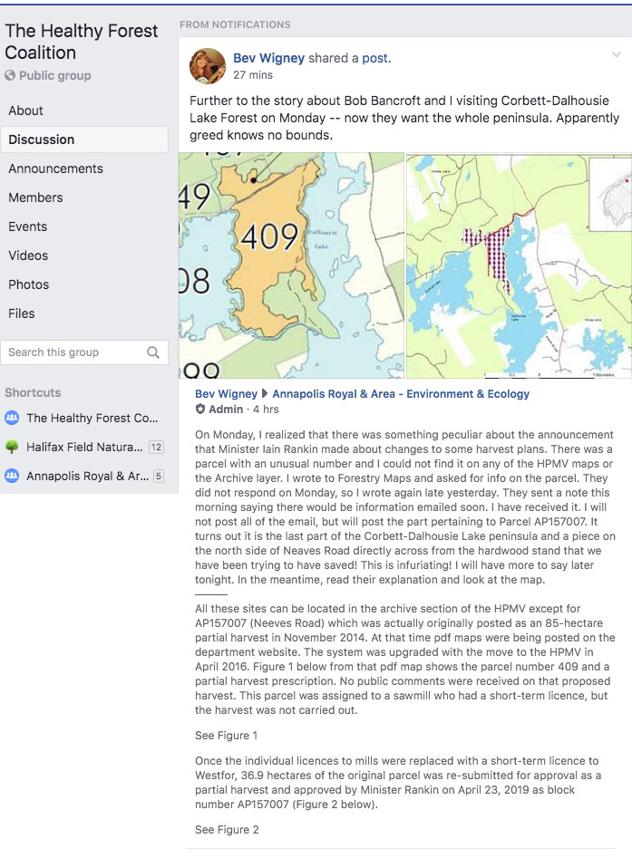
BW: …My next post hasn’t been approved and put up yet, but after digging to find out more about a parcel that was announced via Iain Rankin’s frivolous little post about changes to some parcels, I found out that Westfor is now going after what is left of the remaining third of the Corbett-Dalhousie Lake forest on the peninsula. Also, a tract north of the peninsula on the north side of Neaves Road — also has some great trees in it — I was looking at them on Monday when i was there with Bob Bancroft. Apparently greed knows no bounds. They are determined to totally destroy what remains of our Crown land forests here in Annapolis County. It’s incredible that they seem to have absolutely no respect toward the people of this county. None. Zero. I’m totally disgusted.
Sue ES” It truly is sickening, very underhanded I find and NOT transparent at all and Bev, I suspect that is why all was so silent when asking for further info on Corbett/Dalhousie and why it took so long and was so vague when it did come.
And this post: